
Topografische Karte Marathon
Interaktive Karte
Klicken Sie auf die Karte, um die Höhe anzuzeigen.
Über diese Karte
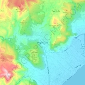
Name: Topografische Karte Marathon, Höhe, Relief.
Durchschnittliche Höhe: 146 m
Minimale Höhe: -1 m
Maximale Höhe: 564 m
World records were not officially recognized by the IAAF until 1 January 2004; previously, the best times for the marathon were referred to as the 'world best'. Courses must conform to IAAF standards for a record to be recognized. However, marathon routes still vary greatly in elevation, course, and surface, making exact comparisons impossible. Typically, the fastest times are set over relatively flat courses near sea level, during good weather conditions and with the assistance of pacesetters.
Andere topografische Karten
Klicken Sie auf eine Karte, um ihre Topografie, ihre Höhe und ihr Relief anzuzeigen.
Αρχή
Greece > Attica > Regional Unit of East Attica
Αρχή, Regional Unit of East Attica, Attica, Greece
Durchschnittliche Höhe: 15 m
Gerakas Municipal Unit
Greece > Attica > Regional Unit of East Attica > Gerakas Municipal Unit
Gerakas Municipal Unit, Municipality of Pallini, Regional Unit of East Attica, Attica, 15344, Greece
Durchschnittliche Höhe: 259 m
Municipality of Dionysos
Greece > Attica > Regional Unit of East Attica
Municipality of Dionysos, Regional Unit of East Attica, Attica, Greece
Durchschnittliche Höhe: 385 m