
Topografische Karte Municipality of Dionysos
Interaktive Karte
Klicken Sie auf die Karte, um die Höhe anzuzeigen.
Über diese Karte
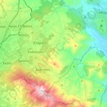
Name: Topografische Karte Municipality of Dionysos, Höhe, Relief.
Durchschnittliche Höhe: 385 m
Minimale Höhe: 21 m
Maximale Höhe: 1.098 m
Andere topografische Karten
Klicken Sie auf eine Karte, um ihre Topografie, ihre Höhe und ihr Relief anzuzeigen.
Αρχή
Greece > Attica > Regional Unit of East Attica
Αρχή, Regional Unit of East Attica, Attica, Greece
Durchschnittliche Höhe: 15 m
Gerakas Municipal Unit
Greece > Attica > Regional Unit of East Attica > Gerakas Municipal Unit
Gerakas Municipal Unit, Municipality of Pallini, Regional Unit of East Attica, Attica, 15344, Greece
Durchschnittliche Höhe: 259 m
Marathon
Greece > Attica > Regional Unit of East Attica
Marathon, Municipality of Marathonas, Regional Unit of East Attica, Attica, 190 07, Greece
Durchschnittliche Höhe: 146 m