
Topografische Karte Αρχή
Interaktive Karte
Klicken Sie auf die Karte, um die Höhe anzuzeigen.
Über diese Karte
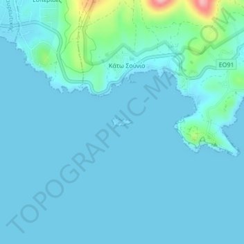
Name: Topografische Karte Αρχή, Höhe, Relief.
Ort: Αρχή, Regional Unit of East Attica, Attica, Greece (37.65175 24.01303 37.65260 24.01579)
Durchschnittliche Höhe: 15 m
Minimale Höhe: 0 m
Maximale Höhe: 146 m
Andere topografische Karten
Klicken Sie auf eine Karte, um ihre Topografie, ihre Höhe und ihr Relief anzuzeigen.
Nea Makri
Greece > Attica > Regional Unit of East Attica > Nea Makri Municipal Unit
Durchschnittliche Höhe: 122 m
Cape Sounion
Greece > Attica > Regional Unit of East Attica > Lavreotiki Municipal Unit
Durchschnittliche Höhe: 8 m
Dioni
Greece > Attica > Regional Unit of East Attica > Pikermi Municipal Unit
Durchschnittliche Höhe: 241 m
Municipality of Vari - Voula - Vouliagmeni
Greece > Attica > Regional Unit of East Attica
Durchschnittliche Höhe: 49 m
Spata
Greece > Attica > Regional Unit of East Attica > Spata-Loutsa Municipal Unit
Durchschnittliche Höhe: 115 m
Artemida
Greece > Attica > Regional Unit of East Attica > Artemida Municipal Unit
Durchschnittliche Höhe: 38 m
Rafina
Greece > Attica > Regional Unit of East Attica > Rafina Municipal Unit
Durchschnittliche Höhe: 44 m
Marathon
Greece > Attica > Regional Unit of East Attica
World records were not officially recognized by the IAAF until 1 January 2004; previously, the best times for the marathon were referred to as the 'world best'. Courses must conform to IAAF standards for a record to be recognized. However, marathon routes still vary greatly in elevation, course, and surface,…
Durchschnittliche Höhe: 146 m
Vouliagmeni Municipal Unit
Greece > Attica > Regional Unit of East Attica
Durchschnittliche Höhe: 20 m
Gerakas Municipal Unit
Greece > Attica > Regional Unit of East Attica > Gerakas Municipal Unit
Durchschnittliche Höhe: 259 m