
Topografische Karte Roštín
Interaktive Karte
Klicken Sie auf die Karte, um die Höhe anzuzeigen.
Über diese Karte
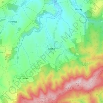
Name: Topografische Karte Roštín, Höhe, Relief.
Durchschnittliche Höhe: 353 m
Minimale Höhe: 231 m
Maximale Höhe: 578 m
Roštín is located about 14 kilometres (9 mi) southwest of Kroměříž and 27 km (17 mi) west of Zlín. The northwestern half of the municipality lies in the Litenčice Hills. The southeastern half lies in a forested landscape of the Chřiby range. Brdo, the highest mountain of the whole Central Moravian Carpathians region with an elevation of 587 m (1,926 ft), is located in the municipality.
Andere topografische Karten
Klicken Sie auf eine Karte, um ihre Topografie, ihre Höhe und ihr Relief anzuzeigen.
Sazovice
Czechia > Central Moravia > Zlínský kraj
Sazovice, okres Zlín, Zlínský kraj, Central Moravia, Czechia
Durchschnittliche Höhe: 235 m
Stupava
Czechia > Central Moravia > Zlínský kraj
Stupava, okres Uherské Hradiště, Zlínský kraj, Central Moravia, Czechia
Durchschnittliche Höhe: 428 m
Kroměříž
Czechia > Central Moravia > Zlínský kraj
Kroměříž, okres Kroměříž, Zlínský kraj, Central Moravia, 767 01, Czechia
Durchschnittliche Höhe: 220 m
Rožnov pod Radhoštěm
Czechia > Central Moravia > Zlínský kraj
Rožnov pod Radhoštěm, okres Vsetín, Zlínský kraj, Central Moravia, 756 61, Czechia
Durchschnittliche Höhe: 521 m