
Topografische Karte Kroměříž
Interaktive Karte
Klicken Sie auf die Karte, um die Höhe anzuzeigen.
Über diese Karte
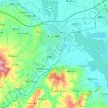
Name: Topografische Karte Kroměříž, Höhe, Relief.
Durchschnittliche Höhe: 220 m
Minimale Höhe: 181 m
Maximale Höhe: 368 m
Kroměříž is located about 20 kilometres (12 mi) northwest of Zlín. About two thirds of the municipal territory lies in the Litenčice Hills, eastern part lies in the Upper Morava Valley. A small southern part extends into the Chřiby mountain range. The highest point of the territory is the hill Obora with an elevation of 322 metres (1,056 ft). The town is situated on both banks of the Morava River.
Andere topografische Karten
Klicken Sie auf eine Karte, um ihre Topografie, ihre Höhe und ihr Relief anzuzeigen.
Sazovice
Czechia > Central Moravia > Zlínský kraj
Sazovice, okres Zlín, Zlínský kraj, Central Moravia, Czechia
Durchschnittliche Höhe: 235 m
Stupava
Czechia > Central Moravia > Zlínský kraj
Stupava, okres Uherské Hradiště, Zlínský kraj, Central Moravia, Czechia
Durchschnittliche Höhe: 428 m
Roštín
Czechia > Central Moravia > Zlínský kraj
Roštín, okres Kroměříž, Zlínský kraj, Central Moravia, 768 03, Czechia
Durchschnittliche Höhe: 353 m
Rožnov pod Radhoštěm
Czechia > Central Moravia > Zlínský kraj
Rožnov pod Radhoštěm, okres Vsetín, Zlínský kraj, Central Moravia, 756 61, Czechia
Durchschnittliche Höhe: 521 m