
Topografische Karte Rožnov pod Radhoštěm
Interaktive Karte
Klicken Sie auf die Karte, um die Höhe anzuzeigen.
Über diese Karte
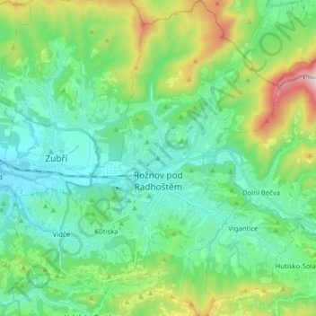
Name: Topografische Karte Rožnov pod Radhoštěm, Höhe, Relief.
Durchschnittliche Höhe: 521 m
Minimale Höhe: 332 m
Maximale Höhe: 1.097 m
The highest point in the territory is located on the hillside of the Velká Polana mountain in the elevation of about 975 metres (3,199 ft). The Radhošť mountain whose name the town bears lies outside the territory.
Andere topografische Karten
Klicken Sie auf eine Karte, um ihre Topografie, ihre Höhe und ihr Relief anzuzeigen.
Sazovice
Czechia > Central Moravia > Zlínský kraj
Sazovice, okres Zlín, Zlínský kraj, Central Moravia, Czechia
Durchschnittliche Höhe: 235 m
Stupava
Czechia > Central Moravia > Zlínský kraj
Stupava, okres Uherské Hradiště, Zlínský kraj, Central Moravia, Czechia
Durchschnittliche Höhe: 428 m
Kroměříž
Czechia > Central Moravia > Zlínský kraj
Kroměříž, okres Kroměříž, Zlínský kraj, Central Moravia, 767 01, Czechia
Durchschnittliche Höhe: 220 m
Roštín
Czechia > Central Moravia > Zlínský kraj
Roštín, okres Kroměříž, Zlínský kraj, Central Moravia, 768 03, Czechia
Durchschnittliche Höhe: 353 m