
Topografische Karte Croxden
Klicken Sie auf die Karte, um die Höhe anzuzeigen.
Über diese Karte
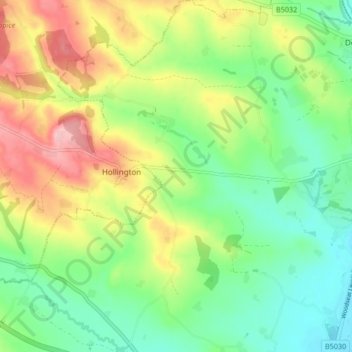
Name: Topografische Karte Croxden, Höhe, Relief.
Durchschnittliche Höhe: 138 m
Minimale Höhe: 81 m
Maximale Höhe: 225 m
Andere topografische Karten
Klicken Sie auf eine Karte, um ihre Topografie, ihre Höhe und ihr Relief anzuzeigen.
Burton upon Trent
United Kingdom > England > Staffordshire > East Staffordshire
Burton is about 109 miles (175 km) north west of London, about 30 miles north east of Birmingham, the UK's second largest city and about 23 miles east of the county town Stafford. It is at the easternmost border of the county of Staffordshire with Derbyshire, its suburbs and the course of the River Trent…
Durchschnittliche Höhe: 69 m
Tutbury Castle
United Kingdom > England > Staffordshire > East Staffordshire > Tutbury
Durchschnittliche Höhe: 66 m
Stubwood
United Kingdom > England > Staffordshire > East Staffordshire > Denstone
Durchschnittliche Höhe: 113 m
Birch Cross
United Kingdom > England > Staffordshire > East Staffordshire > Marchington
Durchschnittliche Höhe: 92 m
Fauld
United Kingdom > England > Staffordshire > East Staffordshire > Hanbury
Durchschnittliche Höhe: 88 m
Blithfield Reservoir
United Kingdom > England > Staffordshire > East Staffordshire > Admaston
Durchschnittliche Höhe: 108 m
Gratwich
United Kingdom > England > Staffordshire > East Staffordshire > Kingstone
Durchschnittliche Höhe: 143 m
Marchington Woodlands
United Kingdom > England > Staffordshire > East Staffordshire
Durchschnittliche Höhe: 120 m
Harlow Wood
United Kingdom > England > Staffordshire > East Staffordshire > Upper Mayfield
Durchschnittliche Höhe: 177 m
Burton upon Trent
United Kingdom > England > Staffordshire > East Staffordshire
Burton is about 109 miles (175 km) north west of London, about 30 miles north east of Birmingham, the UK's second largest city and about 23 miles east of the county town Stafford. It is at the easternmost border of the county of Staffordshire with Derbyshire, its suburbs and the course of the River Trent…
Durchschnittliche Höhe: 69 m