
Topografische Karte Stanton
Klicken Sie auf die Karte, um die Höhe anzuzeigen.
Über diese Karte
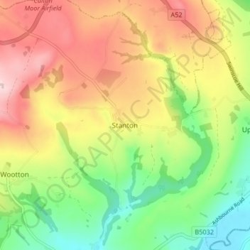
Name: Topografische Karte Stanton, Höhe, Relief.
Durchschnittliche Höhe: 222 m
Minimale Höhe: 102 m
Maximale Höhe: 354 m
Andere topografische Karten
Klicken Sie auf eine Karte, um ihre Topografie, ihre Höhe und ihr Relief anzuzeigen.
Barton-under-Needwood
United Kingdom > England > Staffordshire > East Staffordshire > Barton-under-Needwood
Durchschnittliche Höhe: 69 m
Tutbury Castle
United Kingdom > England > Staffordshire > East Staffordshire > Tutbury
Durchschnittliche Höhe: 66 m
Draycott in the Clay
United Kingdom > England > Staffordshire > East Staffordshire
Durchschnittliche Höhe: 90 m
Blithfield Reservoir
United Kingdom > England > Staffordshire > East Staffordshire > Admaston
Durchschnittliche Höhe: 108 m
Shobnall
United Kingdom > England > Staffordshire > East Staffordshire > Burton-on-Trent
Durchschnittliche Höhe: 56 m
Marchington
United Kingdom > England > Staffordshire > East Staffordshire
Durchschnittliche Höhe: 102 m
Mayfield
United Kingdom > England > Staffordshire > East Staffordshire > Mayfield
Durchschnittliche Höhe: 156 m
River Tean
United Kingdom > England > Staffordshire > East Staffordshire
Durchschnittliche Höhe: 144 m
Hanbury
United Kingdom > England > Staffordshire > East Staffordshire
This locality adjoins the River Dove and includes a steep knoll between much of it and the river, Row Hill; five listed buildings are here all at Grade II. Hanbury's village centre is 0.9 miles (1.4 km) to the south. This hamlet is at an elevation of 61m AOD whereas the village centre of Hanbury is at the…
Durchschnittliche Höhe: 107 m
Harlow Wood
United Kingdom > England > Staffordshire > East Staffordshire > Upper Mayfield
Durchschnittliche Höhe: 177 m
Abbots Bromley
United Kingdom > England > Staffordshire > East Staffordshire
Durchschnittliche Höhe: 114 m
Hoar Cross
United Kingdom > England > Staffordshire > East Staffordshire
Durchschnittliche Höhe: 110 m
Marchington
United Kingdom > England > Staffordshire > East Staffordshire
Durchschnittliche Höhe: 102 m