
Spenden
Rüsten Sie sich für Ihr nächstes Abenteuer:
Als Amazon-Partner erhält diese Website eine Provision für qualifizierte Käufe, ohne zusätzliche Kosten für Sie.
Topografische Karte Burton upon Trent
Klicken Sie auf die Karte, um die Höhe anzuzeigen.
Spenden
Rüsten Sie sich für Ihr nächstes Abenteuer:
Als Amazon-Partner erhält diese Website eine Provision für qualifizierte Käufe, ohne zusätzliche Kosten für Sie.
Burton upon Trent
Burton is about 109 miles (175 km) north west of London, about 30 miles north east of Birmingham, the UK's second largest city and about 23 miles east of the county town Stafford. It is at the easternmost border of the county of Staffordshire with Derbyshire, its suburbs and the course of the River Trent forming part of the county boundary. It is also near the south-eastern terminus of the Trent and Mersey Canal. Burton lies within the northern boundary of the National Forest. The town centre is on the western bank of the River Trent in a valley bottom; its average elevation is about 50 metres above sea level; the village of Winshill and the suburb of Stapenhill rise to 130 m and 100 m respectively.
Spenden
Rüsten Sie sich für Ihr nächstes Abenteuer:
Als Amazon-Partner erhält diese Website eine Provision für qualifizierte Käufe, ohne zusätzliche Kosten für Sie.
Über diese Karte
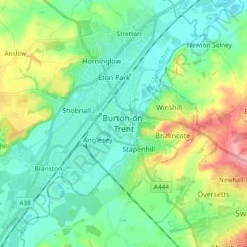
Name: Topografische Karte Burton upon Trent, Höhe, Relief.
Durchschnittliche Höhe: 69 m
Minimale Höhe: 38 m
Maximale Höhe: 149 m
Spenden
Rüsten Sie sich für Ihr nächstes Abenteuer:
Als Amazon-Partner erhält diese Website eine Provision für qualifizierte Käufe, ohne zusätzliche Kosten für Sie.
Andere topografische Karten
Klicken Sie auf eine Karte, um ihre Topografie, ihre Höhe und ihr Relief anzuzeigen.
Tutbury Castle
United Kingdom > England > Staffordshire > East Staffordshire > Tutbury
Durchschnittliche Höhe: 66 m
Barton-under-Needwood
United Kingdom > England > Staffordshire > East Staffordshire
Durchschnittliche Höhe: 69 m
Spenden
Rüsten Sie sich für Ihr nächstes Abenteuer:
Als Amazon-Partner erhält diese Website eine Provision für qualifizierte Käufe, ohne zusätzliche Kosten für Sie.
Shobnall
United Kingdom > England > Staffordshire > East Staffordshire > Burton-on-Trent
Durchschnittliche Höhe: 56 m
Marchington
United Kingdom > England > Staffordshire > East Staffordshire
Durchschnittliche Höhe: 102 m
Mayfield
United Kingdom > England > Staffordshire > East Staffordshire > Mayfield
Durchschnittliche Höhe: 156 m
Spenden
Rüsten Sie sich für Ihr nächstes Abenteuer:
Als Amazon-Partner erhält diese Website eine Provision für qualifizierte Käufe, ohne zusätzliche Kosten für Sie.
Spenden
Rüsten Sie sich für Ihr nächstes Abenteuer:
Als Amazon-Partner erhält diese Website eine Provision für qualifizierte Käufe, ohne zusätzliche Kosten für Sie.
River Tean
United Kingdom > England > Staffordshire > East Staffordshire
Durchschnittliche Höhe: 144 m
Abbots Bromley
United Kingdom > England > Staffordshire > East Staffordshire
Durchschnittliche Höhe: 114 m
Spenden
Rüsten Sie sich für Ihr nächstes Abenteuer:
Als Amazon-Partner erhält diese Website eine Provision für qualifizierte Käufe, ohne zusätzliche Kosten für Sie.
Hoar Cross
United Kingdom > England > Staffordshire > East Staffordshire
Durchschnittliche Höhe: 110 m
Hanbury
United Kingdom > England > Staffordshire > East Staffordshire
This locality adjoins the River Dove and includes a steep knoll between much of it and the river, Row Hill; five listed buildings are here all at Grade II. Hanbury's village centre is 0.9 miles (1.4 km) to the south. This hamlet is at an elevation of 61m AOD whereas the village centre of Hanbury is at the…
Durchschnittliche Höhe: 107 m
Draycott in the Clay
United Kingdom > England > Staffordshire > East Staffordshire > Draycott in the Clay
Durchschnittliche Höhe: 90 m
Spenden
Rüsten Sie sich für Ihr nächstes Abenteuer:
Als Amazon-Partner erhält diese Website eine Provision für qualifizierte Käufe, ohne zusätzliche Kosten für Sie.
Blithfield Reservoir
United Kingdom > England > Staffordshire > East Staffordshire > Admaston
Durchschnittliche Höhe: 108 m
Harlow Wood
United Kingdom > England > Staffordshire > East Staffordshire > Upper Mayfield
Durchschnittliche Höhe: 177 m
Spenden
Rüsten Sie sich für Ihr nächstes Abenteuer:
Als Amazon-Partner erhält diese Website eine Provision für qualifizierte Käufe, ohne zusätzliche Kosten für Sie.