
Topografische Karte Payson
Interaktive Karte
Klicken Sie auf die Karte, um die Höhe anzuzeigen.
Über diese Karte
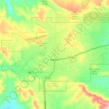
Name: Topografische Karte Payson, Höhe, Relief.
Ort: Payson, Gila County, Arizona, 85072, United States (34.21706 -111.37054 34.27176 -111.27319)
Durchschnittliche Höhe: 1.522 m
Minimale Höhe: 1.379 m
Maximale Höhe: 1.725 m
Located in northern Gila County at an elevation of 5,000 feet (1,500 m), the town has a total area of 19.5 square miles (51 km2). The Mogollon Rim, the southern boundary of the Colorado Plateau, lies to the north of Payson, with elevations exceeding 7,500 feet (2,300 m); there are many cold water lakes on top of the rim. They are stocked with fish by the Arizona Game and Fish Department.
Andere topografische Karten
Klicken Sie auf eine Karte, um ihre Topografie, ihre Höhe und ihr Relief anzuzeigen.
White Tank
United States > Arizona > Gila County
White Tank, Gila County, Arizona, United States
Durchschnittliche Höhe: 1.298 m
White Mountain
United States > Arizona > Gila County
White Mountain, Gila County, Arizona, United States
Durchschnittliche Höhe: 1.363 m
Pine
United States > Arizona > Gila County
Pine, Gila County, Arizona, 85544, United States
Durchschnittliche Höhe: 1.794 m
Miami
United States > Arizona > Gila County
Miami, Gila County, Arizona, 85539, United States
Durchschnittliche Höhe: 1.121 m
Globe
United States > Arizona > Gila County
Globe, Gila County, Arizona, 85532, United States
Durchschnittliche Höhe: 1.173 m
Cypress Hill
United States > Arizona > Gila County > Star Valley
Cypress Hill, Star Valley, Gila County, Arizona, United States
Durchschnittliche Höhe: 1.440 m
Cedar Mesa
United States > Arizona > Gila County
Cedar Mesa, Gila County, Arizona, United States
Durchschnittliche Höhe: 1.638 m
Star Valley
United States > Arizona > Gila County > Star Valley
Star Valley, Gila County, Arizona, United States
Durchschnittliche Höhe: 1.521 m