
Topografische Karte Pine
Interaktive Karte
Klicken Sie auf die Karte, um die Höhe anzuzeigen.
Über diese Karte
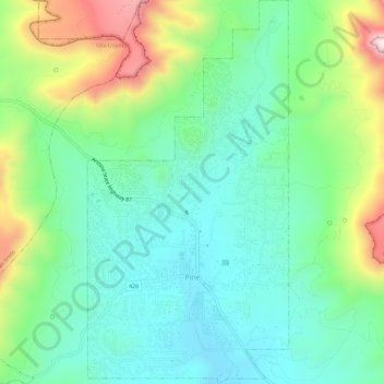
Name: Topografische Karte Pine, Höhe, Relief.
Ort: Pine, Gila County, Arizona, 85544, United States (34.37097 -111.47143 34.41879 -111.44099)
Durchschnittliche Höhe: 1.794 m
Minimale Höhe: 1.613 m
Maximale Höhe: 2.221 m
Pine and the adjacent community of Strawberry are rapidly growing vacation and retirement centers in north-central Arizona, below the Mogollon Rim. Pine's elevation is 5,448 feet (1,661 m), and the Pine post office was established in 1884.
Andere topografische Karten
Klicken Sie auf eine Karte, um ihre Topografie, ihre Höhe und ihr Relief anzuzeigen.
Payson
United States > Arizona > Gila County
Payson, Gila County, Arizona, 85072, United States
Durchschnittliche Höhe: 1.522 m
White Tank
United States > Arizona > Gila County
White Tank, Gila County, Arizona, United States
Durchschnittliche Höhe: 1.298 m
White Mountain
United States > Arizona > Gila County
White Mountain, Gila County, Arizona, United States
Durchschnittliche Höhe: 1.363 m
Miami
United States > Arizona > Gila County
Miami, Gila County, Arizona, 85539, United States
Durchschnittliche Höhe: 1.121 m
Globe
United States > Arizona > Gila County
Globe, Gila County, Arizona, 85532, United States
Durchschnittliche Höhe: 1.173 m
Cypress Hill
United States > Arizona > Gila County > Star Valley
Cypress Hill, Star Valley, Gila County, Arizona, United States
Durchschnittliche Höhe: 1.440 m
Cedar Mesa
United States > Arizona > Gila County
Cedar Mesa, Gila County, Arizona, United States
Durchschnittliche Höhe: 1.638 m
Star Valley
United States > Arizona > Gila County > Star Valley
Star Valley, Gila County, Arizona, United States
Durchschnittliche Höhe: 1.521 m