
Topografische Karte Globe
Interaktive Karte
Klicken Sie auf die Karte, um die Höhe anzuzeigen.
Über diese Karte
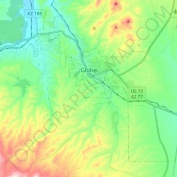
Name: Topografische Karte Globe, Höhe, Relief.
Ort: Globe, Gila County, Arizona, 85532, United States (33.33891 -110.84023 33.42931 -110.70812)
Durchschnittliche Höhe: 1.173 m
Minimale Höhe: 985 m
Maximale Höhe: 1.589 m
Globe has a semi-arid climate, characterized by hot summers and moderate to warm winters. Globe's arid climate is somewhat tempered by its elevation, however, leading to slightly cooler temperatures and slightly more precipitation than Phoenix or Yuma.
Andere topografische Karten
Klicken Sie auf eine Karte, um ihre Topografie, ihre Höhe und ihr Relief anzuzeigen.
Payson
United States > Arizona > Gila County
Payson, Gila County, Arizona, 85072, United States
Durchschnittliche Höhe: 1.522 m
White Tank
United States > Arizona > Gila County
White Tank, Gila County, Arizona, United States
Durchschnittliche Höhe: 1.298 m
White Mountain
United States > Arizona > Gila County
White Mountain, Gila County, Arizona, United States
Durchschnittliche Höhe: 1.363 m
Pine
United States > Arizona > Gila County
Pine, Gila County, Arizona, 85544, United States
Durchschnittliche Höhe: 1.794 m
Miami
United States > Arizona > Gila County
Miami, Gila County, Arizona, 85539, United States
Durchschnittliche Höhe: 1.121 m
Cypress Hill
United States > Arizona > Gila County > Star Valley
Cypress Hill, Star Valley, Gila County, Arizona, United States
Durchschnittliche Höhe: 1.440 m
Cedar Mesa
United States > Arizona > Gila County
Cedar Mesa, Gila County, Arizona, United States
Durchschnittliche Höhe: 1.638 m
Star Valley
United States > Arizona > Gila County > Star Valley
Star Valley, Gila County, Arizona, United States
Durchschnittliche Höhe: 1.521 m