
Topografische Karte Littleborough
Klicken Sie auf die Karte, um die Höhe anzuzeigen.
Littleborough
In the late 18th century, the low-altitude Summit Gap between Littleborough and Walsden was approved as the best route over the Pennines for the Rochdale Canal and the Manchester to Leeds railway; Hollingworth Lake was built at Littleborough's south side as a feeder reservoir to regulate the waters of the canal. This infrastructure encouraged industrialists to modify Littleborough's traditional handloom cloth workshops with a mechanised form of textile production. Attracted to the area's natural resources and modern infrastructure, coal mining, engineering ventures and increasingly large textile mills contributed to Littleborough's population growth and urbanisation, sealing its status as a mill town. Local government reforms established the Littleborough Urban District in 1894 which was governed by its own district council until its abolition in 1974.
Über diese Karte
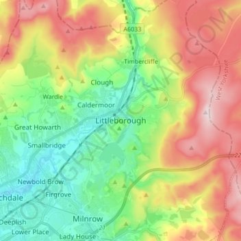
Name: Topografische Karte Littleborough, Höhe, Relief.
Durchschnittliche Höhe: 266 m
Minimale Höhe: 122 m
Maximale Höhe: 473 m
Andere topografische Karten
Klicken Sie auf eine Karte, um ihre Topografie, ihre Höhe und ihr Relief anzuzeigen.
Sheffield
Sheffield nestles on the eastern foothills of the Pennines and is sculpted by a dramatic hill-and-valley system formed where five rivers — the Don, Sheaf, Rivelin, Loxley and Porter — converge, producing steep-sided valleys and gritstone ridgelines with much of the urban area built directly onto hillsides…
Durchschnittliche Höhe: 168 m
Birmingham
Birmingham is a snowy city relative to other large UK conurbations, due to its inland location and comparatively high elevation. Between 1961 and 1990 Birmingham Airport averaged 13.0 days of snow lying annually, compared to 5.33 at London Heathrow. Snow showers often pass through the city via the Cheshire gap…
Durchschnittliche Höhe: 138 m
Lake District National Park
The Lake District is a roughly circular upland massif, deeply dissected by a broadly radial pattern of major valleys which are largely the result of repeated glaciations over the last 2 million years. The apparent radial pattern is not from a central dome, but from an axial watershed extending from St Bees…
Durchschnittliche Höhe: 206 m
Suffolk
The west of the county lies on more resistant Cretaceous chalk. This chalk is responsible for a sweeping tract of largely downland landscapes that stretches from Dorset in the south west to Dover in the south east and north through East Anglia to the Yorkshire Wolds. The chalk is less easily eroded so forms…
Durchschnittliche Höhe: 35 m
Kent
Kent was also the location of the largest number of art schools in the country during the nineteenth century, estimated by the art historian David Haste, to approach two hundred. This is believed to be the result of Kent being a front line county during the Napoleonic Wars. At this time, before the invention…
Durchschnittliche Höhe: 37 m
The Cotswolds National Landscape
United Kingdom > England > Gloucestershire
Durchschnittliche Höhe: 109 m
Greater London
London's topography is characterized by a gently rolling terrain shaped by the River Thames and its tributaries. The city lies within the London Basin, a natural depression bordered by higher grounds such as the North Downs to the south and the Chiltern Hills to the northwest. The Thames flows west to east,…
Durchschnittliche Höhe: 66 m
Cornwall
The interior of the county consists of a roughly east–west spine of infertile and exposed upland, with a series of granite intrusions, such as Bodmin Moor, which contains the highest land within Cornwall. From east to west, and with approximately descending altitude, these are Bodmin Moor, Hensbarrow north…
Durchschnittliche Höhe: 55 m
Exeter
United Kingdom > England > Devon
The city of Exeter was established on the eastern bank of the River Exe on a ridge of land backed by a steep hill. It is at this point that the Exe, having just been joined by the River Creedy, opens onto a wide flood plain and estuary which results in quite common flooding. Historically this was the lowest…
Durchschnittliche Höhe: 56 m
Bath
United Kingdom > England > Bath and North East Somerset
Bath is in the Avon Valley and is surrounded by limestone hills as it is near the southern edge of the Cotswolds, a designated Area of Outstanding Natural Beauty, and the limestone Mendip Hills rise around 7 miles (11 km) south of the city. The hills that surround and make up the city have a maximum altitude…
Durchschnittliche Höhe: 100 m
Leicestershire
A large part of the north-west of the county, around Coalville, forms part of the new National Forest area extending into Derbyshire and Staffordshire. The highest point of the county is Bardon Hill at 278 m (912 ft), which is also a Marilyn; with other hilly/upland areas of around 150–200 metres (490–660…
Durchschnittliche Höhe: 97 m
Surrey
United Kingdom > England > Surrey
The highest elevation in Surrey is Leith Hill near Dorking. It is 295 m (968 ft) above sea level and is the second highest point in southeastern England after Walbury Hill in West Berkshire which is 297 m (974 ft).
Durchschnittliche Höhe: 69 m
Lincoln
United Kingdom > England > Lincolnshire
Lincoln lies 157 mi (253 km) north of London, at an altitude of 67 ft (20.4 m) by the River Witham up to 246 ft (75.0 m) on Castle Hill. It fills a gap in the Lincoln Cliff escarpment, which runs north and south through central Lincolnshire, with altitudes up to 200 feet (61 metres). The city lies on the River…
Durchschnittliche Höhe: 29 m
Yorkshire
In Yorkshire there is a very close relationship between the major topographical areas and the geological period in which they were formed. The Pennine chain of hills in the west is of Carboniferous origin. The central vale is Permo-Triassic. The North York Moors in the north-east of the county are Jurassic in…
Durchschnittliche Höhe: 130 m
South East England
Near Weybridge are the UK headquarters of Sony with SSP Group (situated in Byfleet) and Procter & Gamble (next door to each other on The Heights Business Park near the former Brooklands racing circuit) with Kia Motors UK and Petroleum Geo-Services UK, and Gallaher Group (cigarettes) is to the north, next to…
Durchschnittliche Höhe: 69 m
Dartmoor National Park
United Kingdom > England > Devon
Rainfall tends to be associated with Atlantic depressions or with convection. In summer, convection caused by solar surface heating sometimes forms shower clouds and a large proportion of rainfall falls from showers and thunderstorms at this time of year. The wettest months are November and December and on the…
Durchschnittliche Höhe: 239 m
Cambridge
United Kingdom > England > Cambridge
The city, like most of the UK, has a maritime climate highly influenced by the Gulf Stream. Located in the driest region of Britain, Cambridge's rainfall averages around 570 mm (22.44 in) per year, around half the national average, with some years occasionally falling into the semi-arid (under 500 mm (19.69…
Durchschnittliche Höhe: 18 m
East of England
The East of England region has the lowest elevation range in the UK. Twenty percent of the region is below mean sea level, most of this in North Cambridgeshire, Norfolk and on the Essex Coast. Most of the remaining area is of low elevation, with extensive glacial deposits. The Fens, a large area of reclaimed…
Durchschnittliche Höhe: 39 m
Ipswich
United Kingdom > England > Suffolk
Ipswich experiences an oceanic climate, like the rest of the British Isles, with a narrow range of temperature and rainfall spread evenly throughout the year. One of the two nearest for which data is available is East Bergholt, about 7 miles (11 km) south west of the town centre and at a similar elevation, and…
Durchschnittliche Höhe: 29 m
North East England
North East England has a Marine west coast climate (generally found along the west coast of middle latitude continents) with narrower temperature ranges than the south of England and sufficient precipitation in all months. Summers and winters are mild rather than extremely hot or cold, due to the strong…
Durchschnittliche Höhe: 165 m
Cambridgeshire
Cambridgeshire has a maritime temperate climate which is broadly similar to the rest of the United Kingdom, though it is drier than the UK average due to its low altitude and easterly location, the prevailing southwesterly winds having already deposited moisture on higher ground further west. Average winter…
Durchschnittliche Höhe: 32 m
St Albans
United Kingdom > England > Hertfordshire > St Albans
St Albans was an ancient borough created following the dissolution of the monastery in 1539. It consisted of the ancient parish of St Albans (also known as the Abbey parish) and parts of St Michael and St Peter. The municipal corporation was reformed by the Municipal Corporations Act 1835 and the boundary was…
Durchschnittliche Höhe: 100 m
Rudyard Lake
United Kingdom > England > Staffordshire > Staffordshire Moorlands > Rudyard > Horton
Durchschnittliche Höhe: 205 m
Dilhorne
United Kingdom > England > Staffordshire > Staffordshire Moorlands
Durchschnittliche Höhe: 216 m
Terrington St. Clement
United Kingdom > England > Norfolk > King's Lynn and West Norfolk
Durchschnittliche Höhe: 2 m
Bridgnorth
United Kingdom > England > Shropshire
The town is located in the Severn Valley, where the river passes through a relatively narrow valley with largely-wooded slopes. High Town, the part of the town sited on the west side of the Severn, is built on a notable promontory, at the southern end of which the castle was constructed, and is known as Castle…
Durchschnittliche Höhe: 80 m
Newbury
United Kingdom > England > West Berkshire
Elevations vary from a minimum of 72 m above mean sea level to 122 m at Wash Common. Elevations reach 150–200 m in the directly adjoining hills. The River Kennet and the Kennet and Avon Canal flow east through the centre of the town to reach the Thames at Reading, while the River Lambourn (beside which is…
Durchschnittliche Höhe: 97 m
Lount Wood
United Kingdom > England > Leicestershire > North West Leicestershire > Lount
Durchschnittliche Höhe: 131 m