Topografische Karte Wynyard
Interaktive Karte
Klicken Sie auf die Karte, um die Höhe anzuzeigen.
Über diese Karte
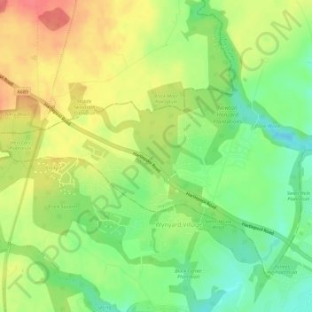
Name: Topografische Karte Wynyard, Höhe, Relief.
Ort: Wynyard, Hartlepool, Tees Valley, England, United Kingdom (54.63131 -1.38375 54.65626 -1.32808)
Durchschnittliche Höhe: 67 m
Minimale Höhe: 36 m
Maximale Höhe: 99 m
Andere topografische Karten
Klicken Sie auf eine Karte, um ihre Topografie, ihre Höhe und ihr Relief anzuzeigen.
Hartlepool
United Kingdom > England > Hartlepool
Hartlepool, Tees Valley, England, TS24 7EQ, United Kingdom
Durchschnittliche Höhe: 16 m
Elwick
United Kingdom > England > Hartlepool
Elwick, Hartlepool, Tees Valley, England, United Kingdom
Durchschnittliche Höhe: 59 m
Teesmouth
United Kingdom > England > Hartlepool
Teesmouth, Hartlepool, Tees Valley, England, TS10 5NX, United Kingdom
Durchschnittliche Höhe: 1 m
Greatham
United Kingdom > England > Hartlepool
Greatham, Hartlepool, Tees Valley, England, United Kingdom
Durchschnittliche Höhe: 12 m
Seaton Carew
United Kingdom > England > Hartlepool
Seaton Carew, Hartlepool, Tees Valley, England, TS25 1BT, United Kingdom
Durchschnittliche Höhe: 4 m