Geolokalisieren
👉 Easily get elevation data in JSON, GeoTIFF and KML formats using Elevation API
Vielen Dank für die Unterstützung dieser Website ❤️
Spenden

Topografische Karte Bolton

Klicken Sie auf die Karte, um die Höhe anzuzeigen.

Über diese Karte

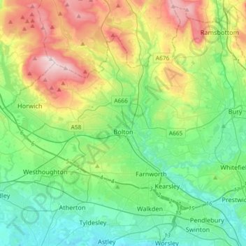
Name: Topografische Karte Bolton, Höhe, Relief.

Ort: Bolton, Greater Manchester, England, United Kingdom (53.52287 -2.62862 53.64603 -2.33704)

Durchschnittliche Höhe: 151 m

Minimale Höhe: 20 m

Maximale Höhe: 456 m

👉 Easily get elevation data in JSON, GeoTIFF and KML formats using Elevation API
Vielen Dank für die Unterstützung dieser Website ❤️
Spenden

Andere topografische Karten

Klicken Sie auf eine Karte, um ihre Topografie, ihre Höhe und ihr Relief anzuzeigen.

London

United Kingdom > England > London

Durchschnittliche Höhe: 42 m

Brighton

United Kingdom > England > Brighton and Hove

Durchschnittliche Höhe: 64 m

Winchelsea Beach

United Kingdom > England > East Sussex > Rother

Durchschnittliche Höhe: 3 m

Cambridge

United Kingdom > England > Cambridge

The city, like most of the UK, has a maritime climate highly influenced by the Gulf Stream. Located in the driest region of Britain, Cambridge's rainfall averages around 570 mm (22.44 in) per year, around half the national average, with some years occasionally falling into the semi-arid (under 500 mm (19.69…

Durchschnittliche Höhe: 18 m

Vielen Dank für die Unterstützung dieser Website ❤️
Spenden

Rüsten Sie sich für Ihr nächstes Abenteuer:

Als Amazon-Partner erhält diese Website eine Provision für qualifizierte Käufe, ohne zusätzliche Kosten für Sie.

Marple

United Kingdom > England > Stockport

Durchschnittliche Höhe: 145 m

Leeds

United Kingdom > England

Lying in the eastern foothills of the Pennines, there is a significant variation in elevation within the city's built-up area. The district ranges from 1,115 feet (340 m) in the far west on the slopes of Ilkley Moor to about 33 feet (10 m) where the rivers Aire and Wharfe cross the eastern boundary. Land rises…

Durchschnittliche Höhe: 94 m

Leicester

United Kingdom > England > City of Leicester

Durchschnittliche Höhe: 109 m

Glastonbury

United Kingdom > England > Glastonbury

Durchschnittliche Höhe: 14 m

York

United Kingdom > England > York

Durchschnittliche Höhe: 21 m

Bedford

United Kingdom > England > Bedford

As with the rest of the United Kingdom, Bedford has a maritime climate, with a limited range of temperatures, and generally even rainfall throughout the year. The nearest Met Office weather station to Bedford is Bedford (Thurleigh) airport, about 6.5 miles (10.5 km) north of Bedford town centre at an elevation…

Durchschnittliche Höhe: 37 m

Dunstable Downs

United Kingdom > England

Durchschnittliche Höhe: 191 m

Loughborough

United Kingdom > England > Leicestershire > Charnwood

Durchschnittliche Höhe: 61 m

Vielen Dank für die Unterstützung dieser Website ❤️
Spenden

Eltham

United Kingdom > England > Greater London

Eltham has a varied topography. Map 6 shows contours, spot heights and water courses. The centre of Eltham is on a plateau at about the 60m level with the High Street running along its centre. There is a scarp slope to the west of the plateau from the top of which are unrestricted views across South London.…

Durchschnittliche Höhe: 48 m

Oswestry

United Kingdom > England > Shropshire

Durchschnittliche Höhe: 158 m

Bridgwater

United Kingdom > England > Bridgwater

Durchschnittliche Höhe: 17 m

Chester

United Kingdom > England > Cheshire West and Chester

Durchschnittliche Höhe: 61 m

Chippenham

United Kingdom > England > Chippenham

Durchschnittliche Höhe: 76 m

Leigh

United Kingdom > England

Durchschnittliche Höhe: 34 m

Claydon

United Kingdom > England > Oxfordshire > Cherwell District

Durchschnittliche Höhe: 126 m

Dovestone reservoir

United Kingdom > England > Oldham

Durchschnittliche Höhe: 322 m

Richmond Park

United Kingdom > England > Greater London

Durchschnittliche Höhe: 26 m

Hull

United Kingdom > England > Kingston upon Hull

Kingston upon Hull is on the northern bank of the Humber Estuary. The city centre is west of the River Hull and close to the Humber. The city is built upon alluvial and glacial deposits which overlie chalk rocks but the underlying chalk has no influence on the topography. The land within the city is generally…

Durchschnittliche Höhe: 21 m

Swindon

United Kingdom > England > Swindon

Swindon has an oceanic climate (Cfb in the Köppen climate classification), like the vast majority of the British Isles, with cool winters and warm summers. The nearest official weather station is RAF Lyneham, about 10 miles (16 km) west southwest of Swindon town centre. The weather station's elevation is 145…

Durchschnittliche Höhe: 108 m

Vielen Dank für die Unterstützung dieser Website ❤️
Spenden

Rüsten Sie sich für Ihr nächstes Abenteuer:

Als Amazon-Partner erhält diese Website eine Provision für qualifizierte Käufe, ohne zusätzliche Kosten für Sie.

Atherton

United Kingdom > England

There were several ministers of note of Chowbent Chapel including James Wood, the "General" (1672–1759), who distinguished himself at the Battle of Preston in 1715. Thomas Walker Horsfield (1792–1837) was a historian and topographer. Joseph Nightingale (1775–1824), born in Chowbent, was a prolific…

Durchschnittliche Höhe: 69 m

Butley Abbey

United Kingdom > England > Suffolk > East Suffolk > Butley

Durchschnittliche Höhe: 9 m

King's Norton

United Kingdom > England > Leicestershire > Harborough

Durchschnittliche Höhe: 147 m

Bough Beech Reservoir

United Kingdom > England > Kent > Sevenoaks

Durchschnittliche Höhe: 78 m

Baldersdale

United Kingdom > England > County Durham

Durchschnittliche Höhe: 356 m

Barden Lake

United Kingdom > England > Kent > Tonbridge and Malling > Tonbridge

Durchschnittliche Höhe: 33 m

Bradford

United Kingdom > England

Bradford is located at 53°45′00″N 01°50′00″W / 53.75000°N 1.83333°W / 53.75000; -1.83333 (53.7500, -1.8333)1. Topographically, it is located in the eastern moorland region of the South Pennines.

Durchschnittliche Höhe: 167 m

Crystal Palace Park

United Kingdom > England > London

Durchschnittliche Höhe: 73 m

Vielen Dank für die Unterstützung dieser Website ❤️
Spenden

Wash

United Kingdom > England > Derbyshire > High Peak

Durchschnittliche Höhe: 282 m

East Finchley

United Kingdom > England > London > East Finchley

Durchschnittliche Höhe: 67 m

Low Eighton

United Kingdom > England > Tyne and Wear > Birtley > Lamesley

Durchschnittliche Höhe: 75 m

Pattingham

United Kingdom > England > Staffordshire > South Staffordshire

Durchschnittliche Höhe: 106 m

Kilburn

United Kingdom > England

Durchschnittliche Höhe: 48 m

Ingleborough

United Kingdom > England > North Yorkshire > Ingleton

Durchschnittliche Höhe: 499 m

Caterham on the Hill

United Kingdom > England > Surrey

Durchschnittliche Höhe: 172 m

City of London

United Kingdom > England > City of London > City of London

The elevation of the City ranges from sea level at the Thames to 21.6 metres (71 ft) at the junction of High Holborn and Chancery Lane. Two small but notable hills are within the historic core, Ludgate Hill to the west and Cornhill to the east. Between them ran the Walbrook, one of the many "lost" rivers or…

Durchschnittliche Höhe: 42 m

Slaithwaite

United Kingdom > England > Kirklees

In the 1848 edition of 'A Topographical Dictionary of England', Samuel Lewis (the editor) wrote:- "the lands are in meadow and pasture, with a small portion of arable; the scenery is bold and romantic. In the quarries of the district are found vegetable fossils, especially firs and other mountain trees. The…

Durchschnittliche Höhe: 241 m

Batley

United Kingdom > England > Kirklees

Durchschnittliche Höhe: 111 m

Halesowen

United Kingdom > England

Durchschnittliche Höhe: 170 m

St Neots

United Kingdom > England > Huntingdonshire > St Neots

Durchschnittliche Höhe: 23 m

St Austell

United Kingdom > England > St Austell

Durchschnittliche Höhe: 104 m

Dunstable

United Kingdom > England > Dunstable

Durchschnittliche Höhe: 146 m

Blackpool

United Kingdom > England > Borough of Blackpool

Durchschnittliche Höhe: 7 m

Heswall

United Kingdom > England

Durchschnittliche Höhe: 36 m

Tottenham

United Kingdom > England

Tottenham's elevation is approximately 33 ft (10 m) above sea level.

Durchschnittliche Höhe: 25 m

Shocklach

United Kingdom > England > Cheshire West and Chester

Durchschnittliche Höhe: 30 m

Rawmarsh

United Kingdom > England

Durchschnittliche Höhe: 64 m

Lower Langford

United Kingdom > England > North Somerset

Durchschnittliche Höhe: 48 m

Stanley Park

United Kingdom > England > Liverpool

Durchschnittliche Höhe: 43 m

Great Meols

United Kingdom > England

Durchschnittliche Höhe: 6 m

Oxton Village

United Kingdom > England

Durchschnittliche Höhe: 32 m

Amberley

United Kingdom > England > Gloucestershire > Stroud

Durchschnittliche Höhe: 133 m

Lytchett Matravers

United Kingdom > England > Lytchett Matravers

Durchschnittliche Höhe: 52 m

Swinton

United Kingdom > England

Durchschnittliche Höhe: 48 m

Lewisham

United Kingdom > England

Durchschnittliche Höhe: 28 m

North West Porth

United Kingdom > England

Durchschnittliche Höhe: 0 m

Wimbledon

United Kingdom > England > Greater London

Durchschnittliche Höhe: 26 m

Old Coulsdon

United Kingdom > England

Durchschnittliche Höhe: 139 m

Seven Sisters

United Kingdom > England > East Sussex > Wealden > Friston

Durchschnittliche Höhe: 35 m

Salisbury

United Kingdom > England > Salisbury

Bishop of Salisbury Hubert Walter was instrumental in the negotiations with Saladin during the Third Crusade, but he spent little time in his diocese prior to his elevation to archbishop of Canterbury. The brothers Herbert and Richard Poore succeeded him and began planning the relocation of the cathedral into…

Durchschnittliche Höhe: 96 m

Kingston upon Thames

United Kingdom > England > Greater London

Durchschnittliche Höhe: 19 m

Harwich

United Kingdom > England > Essex > Parkeston

Durchschnittliche Höhe: 6 m

Wychbold

United Kingdom > England > Worcestershire > Wychavon

Durchschnittliche Höhe: 52 m

Vielen Dank für die Unterstützung dieser Website ❤️
Spenden

Old Town

United Kingdom > England

Durchschnittliche Höhe: 7 m

Wombwell

United Kingdom > England

Durchschnittliche Höhe: 69 m

Westgate

United Kingdom > England > County Durham

Durchschnittliche Höhe: 384 m

Chatham

United Kingdom > England > Medway

Durchschnittliche Höhe: 49 m

Kynance Cove

United Kingdom > England

Durchschnittliche Höhe: 32 m

Leven

United Kingdom > England > East Riding of Yorkshire

Durchschnittliche Höhe: 5 m

Darlaston

United Kingdom > England

Durchschnittliche Höhe: 138 m

Allerford

United Kingdom > England > Somerset

Durchschnittliche Höhe: 112 m

Little Lever

United Kingdom > England > Bolton

Durchschnittliche Höhe: 90 m

Walthamstow

United Kingdom > England

Durchschnittliche Höhe: 21 m

Kennessee Green

United Kingdom > England

Durchschnittliche Höhe: 16 m

Cornwall

United Kingdom > England

Durchschnittliche Höhe: 47 m

Vielen Dank für die Unterstützung dieser Website ❤️
Spenden

Rüsten Sie sich für Ihr nächstes Abenteuer:

Als Amazon-Partner erhält diese Website eine Provision für qualifizierte Käufe, ohne zusätzliche Kosten für Sie.

Newport

United Kingdom > England > Uttlesford > Newport

Durchschnittliche Höhe: 84 m

Watford Gap

United Kingdom > England > West Northamptonshire

Durchschnittliche Höhe: 139 m

Malvern

United Kingdom > England > Worcestershire > Malvern Hills

Malvern lies in the Lower Severn/Avon plain affording it a degree of shelter caused by virtue of its nestling in between the Cotswold hills to the east, the Welsh Hills and Mountains to the west, and Birmingham plateau to the north. Although as with all the British Isles it has a maritime climate, the local…

Durchschnittliche Höhe: 95 m

Calf Crag

United Kingdom > England > Westmorland and Furness

Durchschnittliche Höhe: 471 m

Hammersmith

United Kingdom > England

Durchschnittliche Höhe: 17 m

Tyne and Wear

United Kingdom > England

Durchschnittliche Höhe: 144 m

Bexleyheath

United Kingdom > England

Durchschnittliche Höhe: 29 m

Skelmersdale

United Kingdom > England > Lancashire > West Lancashire

Durchschnittliche Höhe: 70 m

Vielen Dank für die Unterstützung dieser Website ❤️
Spenden

Rüsten Sie sich für Ihr nächstes Abenteuer:

Als Amazon-Partner erhält diese Website eine Provision für qualifizierte Käufe, ohne zusätzliche Kosten für Sie.

Leighton Buzzard

United Kingdom > England > Central Bedfordshire

Durchschnittliche Höhe: 103 m

Burnham-on-Sea

United Kingdom > England > Somerset

Durchschnittliche Höhe: 5 m

Woodbridge

United Kingdom > England > Woodbridge

Durchschnittliche Höhe: 24 m

Retford

United Kingdom > England > Nottinghamshire > Bassetlaw

In 1831, the Gas Works was built by James Malam and gaslights were lit in the town for the first time on 22 December 1831. The Square was lit by a cast iron light bearing five gas lamps at that time. The Gas Works became a target on 2 September 1916 when a German Zeppelin dropped 14 bombs on Retford. The…

Durchschnittliche Höhe: 31 m

Vielen Dank für die Unterstützung dieser Website ❤️
Spenden

Rüsten Sie sich für Ihr nächstes Abenteuer:

Als Amazon-Partner erhält diese Website eine Provision für qualifizierte Käufe, ohne zusätzliche Kosten für Sie.

Aldridge

United Kingdom > England

Durchschnittliche Höhe: 144 m

Tonbridge

United Kingdom > England > Kent > Tonbridge and Malling

Durchschnittliche Höhe: 52 m

Hartlepool

United Kingdom > England > Hartlepool

Durchschnittliche Höhe: 16 m

Milton Keynes

United Kingdom > England > Milton Keynes > Milton Keynes

Durchschnittliche Höhe: 81 m

Vielen Dank für die Unterstützung dieser Website ❤️
Spenden

Rüsten Sie sich für Ihr nächstes Abenteuer:

Als Amazon-Partner erhält diese Website eine Provision für qualifizierte Käufe, ohne zusätzliche Kosten für Sie.

Derby

United Kingdom > England > Derbyshire

Durchschnittliche Höhe: 97 m

Durham

United Kingdom > England > County Durham

Durchschnittliche Höhe: 119 m

Redhill

United Kingdom > England > Surrey > Reigate and Banstead

To the north, the town joins with the village of Merstham, north of which there is a "wind gap" in the chalk hills of the North Downs, at an elevation of 120 metres (390 feet) above sea level, through which the A23 road heads in from London. Geologists have speculated that there may once have been a…

Durchschnittliche Höhe: 107 m

Vielen Dank für die Unterstützung dieser Website ❤️
Spenden

Rüsten Sie sich für Ihr nächstes Abenteuer:

Als Amazon-Partner erhält diese Website eine Provision für qualifizierte Käufe, ohne zusätzliche Kosten für Sie.

Rüsten Sie sich für Ihr nächstes Abenteuer:

🛡️Insektenschutz Spray - Schützt vor Mücken & Insekten
🩴Camping Sandalen - Bequeme Sandalen für Basislager
🎒Wanderrucksack 50L - Geräumiger Trekkingrucksack mit Komfortträgern
🛰️Satelliten-Kommunikation - Notfall-Messenger für Gebiete ohne Mobilfunkempfang
👟Zustiegsschuhe (Approach) - Griffige Schuhe für leichte Klettereien und Felszustiege

Als Amazon-Partner erhält diese Website eine Provision für qualifizierte Käufe, ohne zusätzliche Kosten für Sie.