
Topografische Karte Union Bridge
Interaktive Karte
Klicken Sie auf die Karte, um die Höhe anzuzeigen.
Über diese Karte
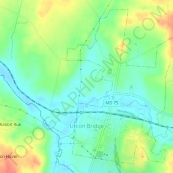
Name: Topografische Karte Union Bridge, Höhe, Relief.
Ort: Union Bridge, Carroll County, Maryland, United States (39.56252 -77.18594 39.58659 -77.16102)
Durchschnittliche Höhe: 138 m
Minimale Höhe: 116 m
Maximale Höhe: 176 m
Andere topografische Karten
Klicken Sie auf eine Karte, um ihre Topografie, ihre Höhe und ihr Relief anzuzeigen.
Gist
United States > Maryland > Carroll County
Gist, Carroll County, Maryland, United States
Durchschnittliche Höhe: 203 m
Kimberly Heights
United States > Maryland > Carroll County
Kimberly Heights, Carroll County, Maryland, United States
Durchschnittliche Höhe: 209 m
Mount Airy
United States > Maryland > Carroll County
Mount Airy, Carroll County, Maryland, 21771, United States
Durchschnittliche Höhe: 221 m
Westminster
United States > Maryland > Carroll County
Westminster, Carroll County, Maryland, United States
Durchschnittliche Höhe: 228 m
Sykesville
United States > Maryland > Carroll County
Sykesville, Carroll County, Maryland, United States
Durchschnittliche Höhe: 152 m