
Topografische Karte Westminster
Interaktive Karte
Klicken Sie auf die Karte, um die Höhe anzuzeigen.
Über diese Karte
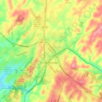
Name: Topografische Karte Westminster, Höhe, Relief.
Ort: Westminster, Carroll County, Maryland, United States (39.54647 -77.04708 39.62053 -76.95920)
Durchschnittliche Höhe: 228 m
Minimale Höhe: 161 m
Maximale Höhe: 290 m
Westminster lies in the humid subtropical climate zone bordering on a humid continental climate, with hot and humid summers and cool winters with highly variable seasonal snowfall. Due to its elevation, distance from the Chesapeake Bay and urban heat island, temperatures in Westminster are often considerably lower than in Baltimore, especially at night.
Andere topografische Karten
Klicken Sie auf eine Karte, um ihre Topografie, ihre Höhe und ihr Relief anzuzeigen.
Gist
United States > Maryland > Carroll County
Gist, Carroll County, Maryland, United States
Durchschnittliche Höhe: 203 m
Kimberly Heights
United States > Maryland > Carroll County
Kimberly Heights, Carroll County, Maryland, United States
Durchschnittliche Höhe: 209 m
Mount Airy
United States > Maryland > Carroll County
Mount Airy, Carroll County, Maryland, 21771, United States
Durchschnittliche Höhe: 221 m
Union Bridge
United States > Maryland > Carroll County
Union Bridge, Carroll County, Maryland, United States
Durchschnittliche Höhe: 138 m
Sykesville
United States > Maryland > Carroll County
Sykesville, Carroll County, Maryland, United States
Durchschnittliche Höhe: 152 m