
Topografische Karte Kimberly Heights
Interaktive Karte
Klicken Sie auf die Karte, um die Höhe anzuzeigen.
Über diese Karte
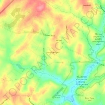
Name: Topografische Karte Kimberly Heights, Höhe, Relief.
Ort: Kimberly Heights, Carroll County, Maryland, United States (39.37733 -77.11998 39.41733 -77.07998)
Durchschnittliche Höhe: 209 m
Minimale Höhe: 162 m
Maximale Höhe: 251 m
Andere topografische Karten
Klicken Sie auf eine Karte, um ihre Topografie, ihre Höhe und ihr Relief anzuzeigen.
Gist
United States > Maryland > Carroll County
Gist, Carroll County, Maryland, United States
Durchschnittliche Höhe: 203 m
Mount Airy
United States > Maryland > Carroll County
Mount Airy, Carroll County, Maryland, 21771, United States
Durchschnittliche Höhe: 221 m
Union Bridge
United States > Maryland > Carroll County
Union Bridge, Carroll County, Maryland, United States
Durchschnittliche Höhe: 138 m
Westminster
United States > Maryland > Carroll County
Westminster, Carroll County, Maryland, United States
Durchschnittliche Höhe: 228 m
Sykesville
United States > Maryland > Carroll County
Sykesville, Carroll County, Maryland, United States
Durchschnittliche Höhe: 152 m