
Topografische Karte Ohtawara
Interaktive Karte
Klicken Sie auf die Karte, um die Höhe anzuzeigen.
Über diese Karte
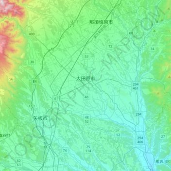
Name: Topografische Karte Ohtawara, Höhe, Relief.
Ort: Ohtawara, Tochigi Prefecture, Japan (36.76840 139.92167 36.94835 140.26739)
Durchschnittliche Höhe: 276 m
Minimale Höhe: 91 m
Maximale Höhe: 1.265 m
Ōtawara is located in northeast Tochigi Prefecture in the foothills of the Nasu region. About 50% of Ōtawara is covered by rice fields with about 12% being mountains and forests. The average elevation of Ōtawara is 217.76 meters. Ōtawara is approximately 40 kilometers north of Utsunomiya, the capital of Tochigi, and approximately 50 km east of the historic city of Nikkō. The city is long in the east and west direction, and the eastern side of the city is bordered by Ibaraki and Fukushima prefectures. The Yamizo Mountains extend along the prefectural border with Ibaraki Prefecture in the eastern part of the prefecture. Rivers include the Naka River, which runs north–south in the eastern part of the city.
Andere topografische Karten
Klicken Sie auf eine Karte, um ihre Topografie, ihre Höhe und ihr Relief anzuzeigen.
Mount Fuji
Japan > Sunto County > Oyama
Mount Fuji, Oyama, Sunto County, Shizuoka Prefecture, Chubu Region, Japan
Durchschnittliche Höhe: 3.261 m
Nishi Mera
Nishi Mera, Koyu County, Miyazaki Prefecture, Japan
Durchschnittliche Höhe: 656 m
Lake Ashi
Japan > Ashigarashimo County > Hakone
Lake Ashi, Hakone, Ashigarashimo County, Kanagawa Prefecture, Japan
Durchschnittliche Höhe: 869 m
Maborikaigan 4-chome Park
Maborikaigan 4-chome Park, Maboricho 3-chome, Yokosuka, Kanagawa Prefecture, 238-8550, Japan
Durchschnittliche Höhe: 22 m
Ibaraki
Ibaraki, Higashiibaraki County, Ibaraki Prefecture, 311-3116, Japan
Durchschnittliche Höhe: 26 m
Lake Sanaru
Lake Sanaru, Hamamatsu, Shizuoka Prefecture, Chubu Region, Japan
Durchschnittliche Höhe: 16 m
Motoyama
Motoyama, Nagaoka County, Kochi Prefecture, 781-3601, Japan
Durchschnittliche Höhe: 679 m
Setouchi
Setouchi, Oshima County, Kagoshima Prefecture, Japan
Durchschnittliche Höhe: 26 m
Higashishirakawa
Higashishirakawa, Kamo County, Gifu Prefecture, Chubu Region, 509-1392, Japan
Durchschnittliche Höhe: 658 m
Odai
Odai, Taki County, Mie Prefecture, 519-2404, Japan
Durchschnittliche Höhe: 381 m