
Topografische Karte Okinawa Island
Interaktive Karte
Klicken Sie auf die Karte, um die Höhe anzuzeigen.
Über diese Karte
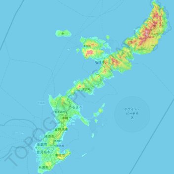
Name: Topografische Karte Okinawa Island, Höhe, Relief.
Ort: Okinawa Island, Okinawa Prefecture, Japan (26.07446 127.62856 26.87552 128.32764)
Durchschnittliche Höhe: 14 m
Minimale Höhe: 0 m
Maximale Höhe: 483 m
The Motobu Peninsula in the north has limestone layers and karst development. In the center and south is mainly a Ryukyu limestone layer and mudstone. The topography is flat, there are few hills over 100 m (328 ft) with very few rivers. The subtropical rains accelerate erosion so there are many drainages and uvala. The southern end of the island consists of uplifted coral reef, whereas the northern half has proportionally more igneous rock. The easily eroded limestone of the south has many caves, the most famous of which is Gyokusendō in Nanjō. The northernmost Cape Hedo is only 22 km (14 mi) away from Yoronjima. Cape Arasaki is the southernmost location of Okinawa island. It is sometimes confused with Cape Kiyanmisaki.
Andere topografische Karten
Klicken Sie auf eine Karte, um ihre Topografie, ihre Höhe und ihr Relief anzuzeigen.
Mount Fuji
Japan > Sunto County > Oyama
Mount Fuji, Oyama, Sunto County, Shizuoka Prefecture, Chubu Region, Japan
Durchschnittliche Höhe: 3.261 m
Nishi Mera
Nishi Mera, Koyu County, Miyazaki Prefecture, Japan
Durchschnittliche Höhe: 656 m
Lake Ashi
Japan > Ashigarashimo County > Hakone
Lake Ashi, Hakone, Ashigarashimo County, Kanagawa Prefecture, Japan
Durchschnittliche Höhe: 869 m
Maborikaigan 4-chome Park
Maborikaigan 4-chome Park, Maboricho 3-chome, Yokosuka, Kanagawa Prefecture, 238-8550, Japan
Durchschnittliche Höhe: 22 m
Ibaraki
Ibaraki, Higashiibaraki County, Ibaraki Prefecture, 311-3116, Japan
Durchschnittliche Höhe: 26 m
Lake Sanaru
Lake Sanaru, Hamamatsu, Shizuoka Prefecture, Chubu Region, Japan
Durchschnittliche Höhe: 16 m
Motoyama
Motoyama, Nagaoka County, Kochi Prefecture, 781-3601, Japan
Durchschnittliche Höhe: 679 m
Setouchi
Setouchi, Oshima County, Kagoshima Prefecture, Japan
Durchschnittliche Höhe: 26 m
Higashishirakawa
Higashishirakawa, Kamo County, Gifu Prefecture, Chubu Region, 509-1392, Japan
Durchschnittliche Höhe: 658 m
Odai
Odai, Taki County, Mie Prefecture, 519-2404, Japan
Durchschnittliche Höhe: 381 m
Nishikigaoka-chuo Park
Nishikigaoka-chuo Park, Nishikigaoka 2-chome, Aoba Ward, Sendai, Miyagi Prefecture, Japan
Durchschnittliche Höhe: 197 m