
Topografische Karte Maniwa
Interaktive Karte
Klicken Sie auf die Karte, um die Höhe anzuzeigen.
Über diese Karte
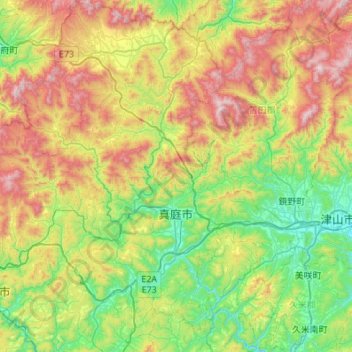
Name: Topografische Karte Maniwa, Höhe, Relief.
Ort: Maniwa, Okayama Prefecture, Japan (34.90020 133.56664 35.34502 133.84560)
Durchschnittliche Höhe: 477 m
Minimale Höhe: 74 m
Maximale Höhe: 1.224 m
Maniwa is located in north-central Okayama Prefecture and is approximately in the center of the Chūgoku Mountains, which forms its northern border with Tottori Prefecture. Occupying 11.6% of Okayama Prefecture, it has the largest area of any municipality in the prefecture. It measures roughly 55 km from North to South, and 35 km from east to west. The mountainous part of the city to the north is dominated by Mount Hiruzen (1,202 m (3,944 ft)) and the Hiruzen Highlands, which is the source of the Asahi River, emerges from Mount Hiruzen in Maniwa, and its upper reaches are located within the town. The river has approximately 146 tributaries and a length of 142 kilometres (88 mi). Major tributaries of the Asahi in Maniwa include the Bitchū, Nakazui, Kōchi, Meki, and the Shinjō rivers. The Hiruzen Highlands sit at an elevation of 500–600 meters above sea-level, and is part of the Daisen-Oki National Park. With Maniwa being far from any major fault lines, the chance of an earthquake above 7.0 magnitude is less than 1%, small compared to other areas of Japan.
Andere topografische Karten
Klicken Sie auf eine Karte, um ihre Topografie, ihre Höhe und ihr Relief anzuzeigen.
Mount Fuji
Japan > Sunto County > Oyama
Mount Fuji, Oyama, Sunto County, Shizuoka Prefecture, Chubu Region, Japan
Durchschnittliche Höhe: 3.261 m
Nishi Mera
Nishi Mera, Koyu County, Miyazaki Prefecture, Japan
Durchschnittliche Höhe: 656 m
Lake Ashi
Japan > Ashigarashimo County > Hakone
Lake Ashi, Hakone, Ashigarashimo County, Kanagawa Prefecture, Japan
Durchschnittliche Höhe: 869 m
Maborikaigan 4-chome Park
Maborikaigan 4-chome Park, Maboricho 3-chome, Yokosuka, Kanagawa Prefecture, 238-8550, Japan
Durchschnittliche Höhe: 22 m
Ibaraki
Ibaraki, Higashiibaraki County, Ibaraki Prefecture, 311-3116, Japan
Durchschnittliche Höhe: 26 m
Lake Sanaru
Lake Sanaru, Hamamatsu, Shizuoka Prefecture, Chubu Region, Japan
Durchschnittliche Höhe: 16 m
Motoyama
Motoyama, Nagaoka County, Kochi Prefecture, 781-3601, Japan
Durchschnittliche Höhe: 679 m
Setouchi
Setouchi, Oshima County, Kagoshima Prefecture, Japan
Durchschnittliche Höhe: 26 m
Higashishirakawa
Higashishirakawa, Kamo County, Gifu Prefecture, Chubu Region, 509-1392, Japan
Durchschnittliche Höhe: 658 m
Odai
Odai, Taki County, Mie Prefecture, 519-2404, Japan
Durchschnittliche Höhe: 381 m
Nishikigaoka-chuo Park
Nishikigaoka-chuo Park, Nishikigaoka 2-chome, Aoba Ward, Sendai, Miyagi Prefecture, Japan
Durchschnittliche Höhe: 197 m