
Spenden
Rüsten Sie sich für Ihr nächstes Abenteuer:
Als Amazon-Partner erhält diese Website eine Provision für qualifizierte Käufe, ohne zusätzliche Kosten für Sie.
Topografische Karte Newcastle-under-Lyme
Klicken Sie auf die Karte, um die Höhe anzuzeigen.
Spenden
Rüsten Sie sich für Ihr nächstes Abenteuer:
Als Amazon-Partner erhält diese Website eine Provision für qualifizierte Käufe, ohne zusätzliche Kosten für Sie.
Über diese Karte
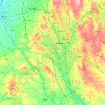
Name: Topografische Karte Newcastle-under-Lyme, Höhe, Relief.
Ort: Newcastle-under-Lyme, Staffordshire, England, United Kingdom (52.87398 -2.47079 53.11581 -2.18109)
Durchschnittliche Höhe: 149 m
Minimale Höhe: 44 m
Maximale Höhe: 330 m
Spenden
Rüsten Sie sich für Ihr nächstes Abenteuer:
Als Amazon-Partner erhält diese Website eine Provision für qualifizierte Käufe, ohne zusätzliche Kosten für Sie.
Andere topografische Karten
Klicken Sie auf eine Karte, um ihre Topografie, ihre Höhe und ihr Relief anzuzeigen.
Red Bull
United Kingdom > England > Staffordshire > Newcastle-under-Lyme > Loggerheads
Durchschnittliche Höhe: 110 m
Burton upon Trent
United Kingdom > England > Staffordshire > East Staffordshire
Burton is about 109 miles (175 km) north west of London, about 30 miles north east of Birmingham, the UK's second largest city and about 23 miles east of the county town Stafford. It is at the easternmost border of the county of Staffordshire with Derbyshire, its suburbs and the course of the River Trent…
Durchschnittliche Höhe: 69 m
Castle Ring
United Kingdom > England > Staffordshire > Cannock Chase > Cannock Wood
It is the highest point on The Chase with an elevation of 242 metres (794 ft).
Durchschnittliche Höhe: 191 m
Spenden
Rüsten Sie sich für Ihr nächstes Abenteuer:
Als Amazon-Partner erhält diese Website eine Provision für qualifizierte Käufe, ohne zusätzliche Kosten für Sie.
Flash
United Kingdom > England > Staffordshire > Staffordshire Moorlands
Flash is a village in the Staffordshire Moorlands and the Peak District National Park, England. At 1,519 feet (463 m) above sea level, it is the highest village in the United Kingdom (some sources claim a height of 1,531 feet (467 m) for Wanlockhead in Scotland, but a survey in 2019 showed that there are no…
Durchschnittliche Höhe: 412 m
Chapel Chorlton
United Kingdom > England > Staffordshire > Newcastle-under-Lyme
Durchschnittliche Höhe: 133 m
Warslow
United Kingdom > England > Staffordshire > Staffordshire Moorlands
Durchschnittliche Höhe: 286 m
Spenden
Rüsten Sie sich für Ihr nächstes Abenteuer:
Als Amazon-Partner erhält diese Website eine Provision für qualifizierte Käufe, ohne zusätzliche Kosten für Sie.
Whitehill
United Kingdom > England > Staffordshire > Kidsgrove > Harriseahead
Durchschnittliche Höhe: 179 m
Wheaton Aston
United Kingdom > England > Staffordshire > South Staffordshire
Durchschnittliche Höhe: 106 m
Baggeridge Country Park
United Kingdom > England > Staffordshire > South Staffordshire
Durchschnittliche Höhe: 146 m
Spenden
Rüsten Sie sich für Ihr nächstes Abenteuer:
Als Amazon-Partner erhält diese Website eine Provision für qualifizierte Käufe, ohne zusätzliche Kosten für Sie.
Dimmingsdale Valley
United Kingdom > England > Staffordshire > Staffordshire Moorlands > Alton
Durchschnittliche Höhe: 177 m
Bradwell
United Kingdom > England > Staffordshire > Newcastle-under-Lyme
Durchschnittliche Höhe: 153 m
Spenden
Rüsten Sie sich für Ihr nächstes Abenteuer:
Als Amazon-Partner erhält diese Website eine Provision für qualifizierte Käufe, ohne zusätzliche Kosten für Sie.
Blackshaw Moor
United Kingdom > England > Staffordshire > Staffordshire Moorlands > Thorncliffe
Durchschnittliche Höhe: 282 m
Draycott Cross
United Kingdom > England > Staffordshire > Staffordshire Moorlands > Boundary
Durchschnittliche Höhe: 183 m
Clay Gates
United Kingdom > England > Staffordshire > South Staffordshire
Durchschnittliche Höhe: 100 m
Marchington Woodlands
United Kingdom > England > Staffordshire > East Staffordshire
Durchschnittliche Höhe: 120 m
Spenden
Rüsten Sie sich für Ihr nächstes Abenteuer:
Als Amazon-Partner erhält diese Website eine Provision für qualifizierte Käufe, ohne zusätzliche Kosten für Sie.
Crateford
United Kingdom > England > Staffordshire > South Staffordshire
Durchschnittliche Höhe: 100 m
Barhill
United Kingdom > England > Staffordshire > Newcastle-under-Lyme > Madeley
Durchschnittliche Höhe: 122 m
The Moss
United Kingdom > England > Staffordshire > Newcastle-under-Lyme > Madeley
Durchschnittliche Höhe: 122 m
The Cloud
United Kingdom > England > Staffordshire > Staffordshire Moorlands
Durchschnittliche Höhe: 194 m
Spenden
Rüsten Sie sich für Ihr nächstes Abenteuer:
Als Amazon-Partner erhält diese Website eine Provision für qualifizierte Käufe, ohne zusätzliche Kosten für Sie.
Upper Tean
United Kingdom > England > Staffordshire > Staffordshire Moorlands
Durchschnittliche Höhe: 175 m
River Barrow
United Kingdom > England > Staffordshire > Tamworth > Leyfields
Durchschnittliche Höhe: 66 m
Spenden
Rüsten Sie sich für Ihr nächstes Abenteuer:
Als Amazon-Partner erhält diese Website eine Provision für qualifizierte Käufe, ohne zusätzliche Kosten für Sie.
Ladderedge Country Park
United Kingdom > England > Staffordshire > Staffordshire Moorlands > Leek
Durchschnittliche Höhe: 176 m
Weston under Lizard
United Kingdom > England > Staffordshire > South Staffordshire
Durchschnittliche Höhe: 111 m
CBeebies Land
United Kingdom > England > Staffordshire > Staffordshire Moorlands > Farley
Durchschnittliche Höhe: 167 m
Spenden
Rüsten Sie sich für Ihr nächstes Abenteuer:
Als Amazon-Partner erhält diese Website eine Provision für qualifizierte Käufe, ohne zusätzliche Kosten für Sie.
Trubshaw
United Kingdom > England > Staffordshire > Kidsgrove > Harriseahead
Durchschnittliche Höhe: 194 m
Gentleshaw
United Kingdom > England > Staffordshire > Lichfield > Longdon
Durchschnittliche Höhe: 174 m
Spenden
Rüsten Sie sich für Ihr nächstes Abenteuer:
Als Amazon-Partner erhält diese Website eine Provision für qualifizierte Käufe, ohne zusätzliche Kosten für Sie.
Huntington
United Kingdom > England > Staffordshire > South Staffordshire
Durchschnittliche Höhe: 166 m
Weston Park
United Kingdom > England > Staffordshire > South Staffordshire > Weston under Lizard
Durchschnittliche Höhe: 113 m
Pattingham
United Kingdom > England > Staffordshire > South Staffordshire
Durchschnittliche Höhe: 106 m
Spenden
Rüsten Sie sich für Ihr nächstes Abenteuer:
Als Amazon-Partner erhält diese Website eine Provision für qualifizierte Käufe, ohne zusätzliche Kosten für Sie.
Coppenhall
United Kingdom > England > Staffordshire > South Staffordshire
Durchschnittliche Höhe: 104 m
Hademore
United Kingdom > England > Staffordshire > Lichfield > Whittington
Durchschnittliche Höhe: 67 m
Spenden
Rüsten Sie sich für Ihr nächstes Abenteuer:
Als Amazon-Partner erhält diese Website eine Provision für qualifizierte Käufe, ohne zusätzliche Kosten für Sie.
Stepping Stones
United Kingdom > England > Staffordshire > Staffordshire Moorlands
Durchschnittliche Höhe: 224 m
Bottomhouse
United Kingdom > England > Staffordshire > Staffordshire Moorlands > Ipstones
Durchschnittliche Höhe: 312 m
Spenden
Rüsten Sie sich für Ihr nächstes Abenteuer:
Als Amazon-Partner erhält diese Website eine Provision für qualifizierte Käufe, ohne zusätzliche Kosten für Sie.
Apedale
United Kingdom > England > Staffordshire > Newcastle-under-Lyme > Chesterton
Durchschnittliche Höhe: 168 m
Levedale
United Kingdom > England > Staffordshire > South Staffordshire > Penkridge
Durchschnittliche Höhe: 98 m
Spenden
Rüsten Sie sich für Ihr nächstes Abenteuer:
Als Amazon-Partner erhält diese Website eine Provision für qualifizierte Käufe, ohne zusätzliche Kosten für Sie.
Roughcote
United Kingdom > England > Staffordshire > Staffordshire Moorlands > Caverswall
Durchschnittliche Höhe: 217 m
Lutley
United Kingdom > England > Staffordshire > South Staffordshire > Enville
Durchschnittliche Höhe: 100 m
Spenden
Rüsten Sie sich für Ihr nächstes Abenteuer:
Als Amazon-Partner erhält diese Website eine Provision für qualifizierte Käufe, ohne zusätzliche Kosten für Sie.
Hulme
United Kingdom > England > Staffordshire > Staffordshire Moorlands
Durchschnittliche Höhe: 209 m
The Brampton
United Kingdom > England > Staffordshire > Newcastle-under-Lyme
Durchschnittliche Höhe: 140 m
Chesterton
United Kingdom > England > Staffordshire > Newcastle-under-Lyme
Durchschnittliche Höhe: 168 m
Harriseahead
United Kingdom > England > Staffordshire > Newcastle-under-Lyme
Durchschnittliche Höhe: 200 m
Spenden
Rüsten Sie sich für Ihr nächstes Abenteuer:
Als Amazon-Partner erhält diese Website eine Provision für qualifizierte Käufe, ohne zusätzliche Kosten für Sie.
Talke Pits
United Kingdom > England > Staffordshire > Newcastle-under-Lyme > Talke
Durchschnittliche Höhe: 179 m
Spenden
Rüsten Sie sich für Ihr nächstes Abenteuer:
Als Amazon-Partner erhält diese Website eine Provision für qualifizierte Käufe, ohne zusätzliche Kosten für Sie.
Hollington
United Kingdom > England > Staffordshire > Staffordshire Moorlands
Durchschnittliche Höhe: 151 m
Cauldon Lowe
United Kingdom > England > Staffordshire > Staffordshire Moorlands
Durchschnittliche Höhe: 292 m
Aqualate Mere
United Kingdom > England > Staffordshire > Stafford > Forton
Durchschnittliche Höhe: 74 m
Blore
United Kingdom > England > Staffordshire > Newcastle-under-Lyme > Loggerheads
Durchschnittliche Höhe: 137 m
Spenden
Rüsten Sie sich für Ihr nächstes Abenteuer:
Als Amazon-Partner erhält diese Website eine Provision für qualifizierte Käufe, ohne zusätzliche Kosten für Sie.
Six Ashes
United Kingdom > England > Staffordshire > South Staffordshire > Bobbington
Durchschnittliche Höhe: 125 m
The Roaches
United Kingdom > England > Staffordshire > Staffordshire Moorlands
Durchschnittliche Höhe: 356 m
Ashley Dale
United Kingdom > England > Staffordshire > Newcastle-under-Lyme > Loggerheads
Durchschnittliche Höhe: 172 m
Spenden
Rüsten Sie sich für Ihr nächstes Abenteuer:
Als Amazon-Partner erhält diese Website eine Provision für qualifizierte Käufe, ohne zusätzliche Kosten für Sie.
River Barrow
United Kingdom > England > Staffordshire > Tamworth > Leyfields
Durchschnittliche Höhe: 66 m
Werrington
United Kingdom > England > Staffordshire > Staffordshire Moorlands
Durchschnittliche Höhe: 229 m
Stubwood
United Kingdom > England > Staffordshire > East Staffordshire > Denstone
Durchschnittliche Höhe: 113 m
Spenden
Rüsten Sie sich für Ihr nächstes Abenteuer:
Als Amazon-Partner erhält diese Website eine Provision für qualifizierte Käufe, ohne zusätzliche Kosten für Sie.
Birch Cross
United Kingdom > England > Staffordshire > East Staffordshire > Marchington
Durchschnittliche Höhe: 92 m
Wain Lea
United Kingdom > England > Staffordshire > Newcastle-under-Lyme > Harriseahead
Durchschnittliche Höhe: 207 m
Fauld
United Kingdom > England > Staffordshire > East Staffordshire > Hanbury
Durchschnittliche Höhe: 88 m
Spenden
Rüsten Sie sich für Ihr nächstes Abenteuer:
Als Amazon-Partner erhält diese Website eine Provision für qualifizierte Käufe, ohne zusätzliche Kosten für Sie.
Burton upon Trent
United Kingdom > England > Staffordshire > East Staffordshire
Burton is about 109 miles (175 km) north west of London, about 30 miles north east of Birmingham, the UK's second largest city and about 23 miles east of the county town Stafford. It is at the easternmost border of the county of Staffordshire with Derbyshire, its suburbs and the course of the River Trent…
Durchschnittliche Höhe: 69 m
Bignall End
United Kingdom > England > Staffordshire > Newcastle-under-Lyme > Audley
Durchschnittliche Höhe: 150 m
Halfpenny Green
United Kingdom > England > Staffordshire > South Staffordshire
Durchschnittliche Höhe: 91 m
Spenden
Rüsten Sie sich für Ihr nächstes Abenteuer:
Als Amazon-Partner erhält diese Website eine Provision für qualifizierte Käufe, ohne zusätzliche Kosten für Sie.
Biddulph Grange Country Park
United Kingdom > England > Staffordshire > Staffordshire Moorlands > Biddulph > Biddulph Moor
Durchschnittliche Höhe: 229 m
Moneystone Quarry
United Kingdom > England > Staffordshire > Staffordshire Moorlands > Kingsley > Whiston Eaves
Durchschnittliche Höhe: 202 m
Rudyard Lake
United Kingdom > England > Staffordshire > Staffordshire Moorlands > Rudyard > Horton
Durchschnittliche Höhe: 205 m
Spenden
Rüsten Sie sich für Ihr nächstes Abenteuer:
Als Amazon-Partner erhält diese Website eine Provision für qualifizierte Käufe, ohne zusätzliche Kosten für Sie.
Hales Hall Pool
United Kingdom > England > Staffordshire > Staffordshire Moorlands > Cheadle
Durchschnittliche Höhe: 182 m
Red Street
United Kingdom > England > Staffordshire > Newcastle-under-Lyme
Durchschnittliche Höhe: 171 m
Mottey Meadows NNR
United Kingdom > England > Staffordshire > South Staffordshire > Wheaton Aston
Durchschnittliche Höhe: 110 m
Spenden
Rüsten Sie sich für Ihr nächstes Abenteuer:
Als Amazon-Partner erhält diese Website eine Provision für qualifizierte Käufe, ohne zusätzliche Kosten für Sie.
Brown Edge
United Kingdom > England > Staffordshire > Staffordshire Moorlands
Durchschnittliche Höhe: 197 m
Whiston
United Kingdom > England > Staffordshire > South Staffordshire > Penkridge
Durchschnittliche Höhe: 95 m
Cellarhead
United Kingdom > England > Staffordshire > Staffordshire Moorlands
Durchschnittliche Höhe: 240 m
Spenden
Rüsten Sie sich für Ihr nächstes Abenteuer:
Als Amazon-Partner erhält diese Website eine Provision für qualifizierte Käufe, ohne zusätzliche Kosten für Sie.
Whitmore Heath
United Kingdom > England > Staffordshire > Newcastle-under-Lyme > Whitmore
Durchschnittliche Höhe: 141 m
Spenden
Rüsten Sie sich für Ihr nächstes Abenteuer:
Als Amazon-Partner erhält diese Website eine Provision für qualifizierte Käufe, ohne zusätzliche Kosten für Sie.