
Spenden
Rüsten Sie sich für Ihr nächstes Abenteuer:
Als Amazon-Partner erhält diese Website eine Provision für qualifizierte Käufe, ohne zusätzliche Kosten für Sie.
Topografische Karte Lanier Lake
Klicken Sie auf die Karte, um die Höhe anzuzeigen.
Spenden
Rüsten Sie sich für Ihr nächstes Abenteuer:
Als Amazon-Partner erhält diese Website eine Provision für qualifizierte Käufe, ohne zusätzliche Kosten für Sie.
Über diese Karte
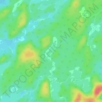
Name: Topografische Karte Lanier Lake, Höhe, Relief.
Durchschnittliche Höhe: 403 m
Minimale Höhe: 384 m
Maximale Höhe: 443 m
Spenden
Rüsten Sie sich für Ihr nächstes Abenteuer:
Als Amazon-Partner erhält diese Website eine Provision für qualifizierte Käufe, ohne zusätzliche Kosten für Sie.
Andere topografische Karten
Klicken Sie auf eine Karte, um ihre Topografie, ihre Höhe und ihr Relief anzuzeigen.
Montreal River Harbour
Canada > Ontario > Algoma District > Unorganized North Algoma
Durchschnittliche Höhe: 212 m
Mashagama Lake
Canada > Ontario > Algoma District > Unorganized North Algoma
Durchschnittliche Höhe: 458 m
Spenden
Rüsten Sie sich für Ihr nächstes Abenteuer:
Als Amazon-Partner erhält diese Website eine Provision für qualifizierte Käufe, ohne zusätzliche Kosten für Sie.
Daisy Lake
Canada > Ontario > Algoma District > Unorganized North Algoma
Durchschnittliche Höhe: 457 m
Raven Lake
Canada > Ontario > Algoma District > Unorganized North Algoma
Durchschnittliche Höhe: 371 m
Burnt Lake
Canada > Ontario > Algoma District > Unorganized North Algoma
Durchschnittliche Höhe: 444 m
Moccasin Lake
Canada > Ontario > Algoma District > Unorganized North Algoma
Durchschnittliche Höhe: 477 m
Spenden
Rüsten Sie sich für Ihr nächstes Abenteuer:
Als Amazon-Partner erhält diese Website eine Provision für qualifizierte Käufe, ohne zusätzliche Kosten für Sie.
Clayton Lake
Canada > Ontario > Algoma District > Unorganized North Algoma
Durchschnittliche Höhe: 381 m
Kabinakagami Lake
Canada > Ontario > Algoma District > Unorganized North Algoma
Durchschnittliche Höhe: 332 m
Pancake Bay
Canada > Ontario > Algoma District > Unorganized North Algoma
Durchschnittliche Höhe: 180 m
Thunder Falls
Canada > Ontario > Algoma District > Unorganized North Algoma
Durchschnittliche Höhe: 286 m
Spenden
Rüsten Sie sich für Ihr nächstes Abenteuer:
Als Amazon-Partner erhält diese Website eine Provision für qualifizierte Käufe, ohne zusätzliche Kosten für Sie.
Batchewana
Canada > Ontario > Algoma District > Unorganized North Algoma
Durchschnittliche Höhe: 370 m
Ogidaki Mountain
Canada > Ontario > Algoma District > Unorganized North Algoma
Durchschnittliche Höhe: 556 m
Searchmont
Canada > Ontario > Algoma District > Unorganized North Algoma
Durchschnittliche Höhe: 285 m
Spenden
Rüsten Sie sich für Ihr nächstes Abenteuer:
Als Amazon-Partner erhält diese Website eine Provision für qualifizierte Käufe, ohne zusätzliche Kosten für Sie.
Batchawana Bay
Canada > Ontario > Algoma District > Unorganized North Algoma
Durchschnittliche Höhe: 198 m
Dog Lake Narrows
Canada > Ontario > Algoma District > Unorganized North Algoma > Missanabie
Durchschnittliche Höhe: 335 m
Goulais Bay
Canada > Ontario > Algoma District > Unorganized North Algoma
Durchschnittliche Höhe: 189 m
Spenden
Rüsten Sie sich für Ihr nächstes Abenteuer:
Als Amazon-Partner erhält diese Website eine Provision für qualifizierte Käufe, ohne zusätzliche Kosten für Sie.
Northland Lake
Canada > Ontario > Algoma District > Unorganized North Algoma
Durchschnittliche Höhe: 387 m
Manitowik Lake
Canada > Ontario > Algoma District > Unorganized North Algoma
Durchschnittliche Höhe: 394 m
Mosambik Lake
Canada > Ontario > Algoma District > Unorganized North Algoma
Durchschnittliche Höhe: 363 m
Goulais River
Canada > Ontario > Algoma District > Unorganized North Algoma
Durchschnittliche Höhe: 362 m
Spenden
Rüsten Sie sich für Ihr nächstes Abenteuer:
Als Amazon-Partner erhält diese Website eine Provision für qualifizierte Käufe, ohne zusätzliche Kosten für Sie.
Agawa Canyon
Canada > Ontario > Algoma District > Unorganized North Algoma
Durchschnittliche Höhe: 409 m
Kimiwan Creek;Kimiwan Lakes
Canada > Ontario > Algoma District > Unorganized North Algoma
Durchschnittliche Höhe: 442 m
Tilley Lakes
Canada > Ontario > Algoma District > Unorganized North Algoma
Durchschnittliche Höhe: 301 m
Agawa Islands
Canada > Ontario > Algoma District > Unorganized North Algoma
Durchschnittliche Höhe: 314 m
Spenden
Rüsten Sie sich für Ihr nächstes Abenteuer:
Als Amazon-Partner erhält diese Website eine Provision für qualifizierte Käufe, ohne zusätzliche Kosten für Sie.
Wakomata Lake
Canada > Ontario > Algoma District > Unorganized North Algoma
Durchschnittliche Höhe: 380 m
Alligator Point
Canada > Ontario > Algoma District > Unorganized North Algoma
Durchschnittliche Höhe: 319 m
Flack Lake
Canada > Ontario > Algoma District > Unorganized North Algoma
Durchschnittliche Höhe: 384 m
Spenden
Rüsten Sie sich für Ihr nächstes Abenteuer:
Als Amazon-Partner erhält diese Website eine Provision für qualifizierte Käufe, ohne zusätzliche Kosten für Sie.
Harmony Beach
Canada > Ontario > Algoma District > Unorganized North Algoma
Durchschnittliche Höhe: 217 m
Albany Forks
Canada > Ontario > Algoma District > Unorganized North Algoma
Durchschnittliche Höhe: 324 m
Caddy Lake
Canada > Ontario > Algoma District > Unorganized North Algoma
Durchschnittliche Höhe: 424 m
Cedar Falls
Canada > Ontario > Algoma District > Unorganized North Algoma
Durchschnittliche Höhe: 345 m
Spenden
Rüsten Sie sich für Ihr nächstes Abenteuer:
Als Amazon-Partner erhält diese Website eine Provision für qualifizierte Käufe, ohne zusätzliche Kosten für Sie.
Esnagi Lake
Canada > Ontario > Algoma District > Unorganized North Algoma
Durchschnittliche Höhe: 391 m
Kabinakagamisis Lake
Canada > Ontario > Algoma District > Unorganized North Algoma
Durchschnittliche Höhe: 324 m
Chapleau River
Canada > Ontario > Algoma District > Unorganized North Algoma
Durchschnittliche Höhe: 328 m