
Spenden
Rüsten Sie sich für Ihr nächstes Abenteuer:
Als Amazon-Partner erhält diese Website eine Provision für qualifizierte Käufe, ohne zusätzliche Kosten für Sie.
Topografische Karte Northland Lake
Klicken Sie auf die Karte, um die Höhe anzuzeigen.
Spenden
Rüsten Sie sich für Ihr nächstes Abenteuer:
Als Amazon-Partner erhält diese Website eine Provision für qualifizierte Käufe, ohne zusätzliche Kosten für Sie.
Über diese Karte
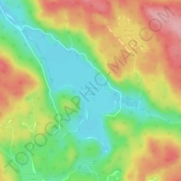
Name: Topografische Karte Northland Lake, Höhe, Relief.
Durchschnittliche Höhe: 387 m
Minimale Höhe: 323 m
Maximale Höhe: 463 m
Spenden
Rüsten Sie sich für Ihr nächstes Abenteuer:
Als Amazon-Partner erhält diese Website eine Provision für qualifizierte Käufe, ohne zusätzliche Kosten für Sie.
Andere topografische Karten
Klicken Sie auf eine Karte, um ihre Topografie, ihre Höhe und ihr Relief anzuzeigen.
Searchmont
Canada > Ontario > Algoma District > Unorganized North Algoma
Durchschnittliche Höhe: 285 m
Alpha Lake
Canada > Ontario > Algoma District > Unorganized North Algoma
Durchschnittliche Höhe: 314 m
Spenden
Rüsten Sie sich für Ihr nächstes Abenteuer:
Als Amazon-Partner erhält diese Website eine Provision für qualifizierte Käufe, ohne zusätzliche Kosten für Sie.
Batchawana Bay
Canada > Ontario > Algoma District > Unorganized North Algoma
Durchschnittliche Höhe: 198 m
Goulais Bay
Canada > Ontario > Algoma District > Unorganized North Algoma
Durchschnittliche Höhe: 189 m
Spenden
Rüsten Sie sich für Ihr nächstes Abenteuer:
Als Amazon-Partner erhält diese Website eine Provision für qualifizierte Käufe, ohne zusätzliche Kosten für Sie.
Fire River
Canada > Ontario > Algoma District > Unorganized North Algoma
Durchschnittliche Höhe: 399 m
Agawa Canyon
Canada > Ontario > Algoma District > Unorganized North Algoma
Durchschnittliche Höhe: 409 m
Montreal River
Canada > Ontario > Algoma District > Unorganized North Algoma
Durchschnittliche Höhe: 360 m
Limerick Lake
Canada > Ontario > Algoma District > Unorganized North Algoma
Durchschnittliche Höhe: 505 m
Spenden
Rüsten Sie sich für Ihr nächstes Abenteuer:
Als Amazon-Partner erhält diese Website eine Provision für qualifizierte Käufe, ohne zusätzliche Kosten für Sie.
Agawa Islands
Canada > Ontario > Algoma District > Unorganized North Algoma
Durchschnittliche Höhe: 314 m
Pancake Bay
Canada > Ontario > Algoma District > Unorganized North Algoma
Durchschnittliche Höhe: 180 m
Thunder Falls
Canada > Ontario > Algoma District > Unorganized North Algoma
Durchschnittliche Höhe: 286 m
Batchewana
Canada > Ontario > Algoma District > Unorganized North Algoma
Durchschnittliche Höhe: 370 m
Spenden
Rüsten Sie sich für Ihr nächstes Abenteuer:
Als Amazon-Partner erhält diese Website eine Provision für qualifizierte Käufe, ohne zusätzliche Kosten für Sie.
Ogidaki Mountain
Canada > Ontario > Algoma District > Unorganized North Algoma
Durchschnittliche Höhe: 556 m
Montreal River Harbour
Canada > Ontario > Algoma District > Unorganized North Algoma
Durchschnittliche Höhe: 212 m
Montreal Island
Canada > Ontario > Algoma District > Unorganized North Algoma
Durchschnittliche Höhe: 190 m
Spenden
Rüsten Sie sich für Ihr nächstes Abenteuer:
Als Amazon-Partner erhält diese Website eine Provision für qualifizierte Käufe, ohne zusätzliche Kosten für Sie.
Seymour Lake
Canada > Ontario > Algoma District > Unorganized North Algoma
Durchschnittliche Höhe: 436 m
Albany Forks
Canada > Ontario > Algoma District > Unorganized North Algoma
Durchschnittliche Höhe: 324 m
Cedar Falls
Canada > Ontario > Algoma District > Unorganized North Algoma
Durchschnittliche Höhe: 345 m
Spenden
Rüsten Sie sich für Ihr nächstes Abenteuer:
Als Amazon-Partner erhält diese Website eine Provision für qualifizierte Käufe, ohne zusätzliche Kosten für Sie.
Lanier Lake
Canada > Ontario > Algoma District > Unorganized North Algoma
Durchschnittliche Höhe: 403 m
Dog Lake Narrows
Canada > Ontario > Algoma District > Unorganized North Algoma > Missanabie
Durchschnittliche Höhe: 335 m
Alligator Point
Canada > Ontario > Algoma District > Unorganized North Algoma
Durchschnittliche Höhe: 319 m
Harmony Beach
Canada > Ontario > Algoma District > Unorganized North Algoma
Durchschnittliche Höhe: 217 m
Spenden
Rüsten Sie sich für Ihr nächstes Abenteuer:
Als Amazon-Partner erhält diese Website eine Provision für qualifizierte Käufe, ohne zusätzliche Kosten für Sie.