
Topografische Karte Manitowik Lake
Klicken Sie auf die Karte, um die Höhe anzuzeigen.
Über diese Karte
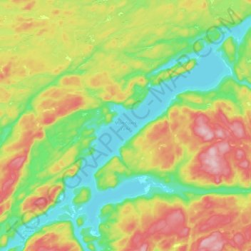
Name: Topografische Karte Manitowik Lake, Höhe, Relief.
Durchschnittliche Höhe: 394 m
Minimale Höhe: 301 m
Maximale Höhe: 527 m
Andere topografische Karten
Klicken Sie auf eine Karte, um ihre Topografie, ihre Höhe und ihr Relief anzuzeigen.
Dog Lake Narrows
Canada > Ontario > Algoma District > Unorganized North Algoma > Missanabie
Durchschnittliche Höhe: 335 m
Lucille Lake;Wood Creek
Canada > Ontario > Algoma District > Unorganized North Algoma
Durchschnittliche Höhe: 441 m
Searchmont
Canada > Ontario > Algoma District > Unorganized North Algoma
Durchschnittliche Höhe: 285 m
Alpha Lake
Canada > Ontario > Algoma District > Unorganized North Algoma
Durchschnittliche Höhe: 314 m
Batchawana Bay
Canada > Ontario > Algoma District > Unorganized North Algoma
Durchschnittliche Höhe: 198 m
Goulais Bay
Canada > Ontario > Algoma District > Unorganized North Algoma
Durchschnittliche Höhe: 189 m
Seymour Lake
Canada > Ontario > Algoma District > Unorganized North Algoma
Durchschnittliche Höhe: 436 m
Fire River
Canada > Ontario > Algoma District > Unorganized North Algoma
Durchschnittliche Höhe: 399 m
Agawa Canyon
Canada > Ontario > Algoma District > Unorganized North Algoma
Durchschnittliche Höhe: 409 m
Montreal River
Canada > Ontario > Algoma District > Unorganized North Algoma
Durchschnittliche Höhe: 360 m
Limerick Lake
Canada > Ontario > Algoma District > Unorganized North Algoma
Durchschnittliche Höhe: 505 m
Agawa Islands
Canada > Ontario > Algoma District > Unorganized North Algoma
Durchschnittliche Höhe: 314 m
Pancake Bay
Canada > Ontario > Algoma District > Unorganized North Algoma
Durchschnittliche Höhe: 180 m
Thunder Falls
Canada > Ontario > Algoma District > Unorganized North Algoma
Durchschnittliche Höhe: 286 m
Batchewana
Canada > Ontario > Algoma District > Unorganized North Algoma
Durchschnittliche Höhe: 370 m
Ogidaki Mountain
Canada > Ontario > Algoma District > Unorganized North Algoma
Durchschnittliche Höhe: 556 m
Montreal River Harbour
Canada > Ontario > Algoma District > Unorganized North Algoma
Durchschnittliche Höhe: 212 m
Montreal Island
Canada > Ontario > Algoma District > Unorganized North Algoma
Durchschnittliche Höhe: 190 m
Albany Forks
Canada > Ontario > Algoma District > Unorganized North Algoma
Durchschnittliche Höhe: 324 m
Cedar Falls
Canada > Ontario > Algoma District > Unorganized North Algoma
Durchschnittliche Höhe: 345 m
Lanier Lake
Canada > Ontario > Algoma District > Unorganized North Algoma
Durchschnittliche Höhe: 403 m
Missinaibi Provincial Park
Canada > Ontario > Algoma District > Unorganized North Algoma
Durchschnittliche Höhe: 351 m
Dog Lake Narrows
Canada > Ontario > Algoma District > Unorganized North Algoma > Missanabie
Durchschnittliche Höhe: 335 m
Alligator Point
Canada > Ontario > Algoma District > Unorganized North Algoma
Durchschnittliche Höhe: 319 m
Harmony Beach
Canada > Ontario > Algoma District > Unorganized North Algoma
Durchschnittliche Höhe: 217 m