Geolokalisieren

Topografische Karte Puxallos

Interaktive Karte

Klicken Sie auf die Karte, um die Höhe anzuzeigen.

Über diese Karte

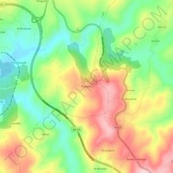
Name: Topografische Karte Puxallos, Höhe, Relief.

Ort: Puxallos, Catasós, Lalín, Deza, Pontevedra, Galicia, 36518, España (42.58581 -8.10352 42.62581 -8.06352)

Durchschnittliche Höhe: 593 m

Minimale Höhe: 485 m

Maximale Höhe: 725 m

Andere topografische Karten

Klicken Sie auf eine Karte, um ihre Topografie, ihre Höhe und ihr Relief anzuzeigen.

Xestoso

España > Galicia > Deza

Xestoso, Silleda, Deza, Pontevedra, Galicia, España

Durchschnittliche Höhe: 641 m

Agolada

España > Galicia > Deza

Agolada, Deza, Pontevedra, Galicia, 36520, España

Durchschnittliche Höhe: 569 m

Pontenoufe

España > Galicia > Deza

Pontenoufe, A Xesta, Lalín, Deza, Pontevedra, Galicia, 36515, España

Durchschnittliche Höhe: 567 m

O Castro

España > Galicia > Deza

O Castro, Dozón, Deza, Pontevedra, Galicia, 36518, España

Durchschnittliche Höhe: 717 m

Dornelas

España > Galicia > Deza

Dornelas, Silleda, Deza, Pontevedra, Galicia, España

Durchschnittliche Höhe: 240 m