
Topografische Karte Xestoso
Interaktive Karte
Klicken Sie auf die Karte, um die Höhe anzuzeigen.
Über diese Karte
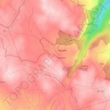
Name: Topografische Karte Xestoso, Höhe, Relief.
Ort: Xestoso, Silleda, Deza, Pontevedra, Galicia, España (42.65038 -8.35094 42.68331 -8.31522)
Durchschnittliche Höhe: 641 m
Minimale Höhe: 427 m
Maximale Höhe: 698 m
Andere topografische Karten
Klicken Sie auf eine Karte, um ihre Topografie, ihre Höhe und ihr Relief anzuzeigen.
Pontenoufe
Pontenoufe, A Xesta, Lalín, Deza, Pontevedra, Galicia, 36515, España
Durchschnittliche Höhe: 567 m