
Spenden
Rüsten Sie sich für Ihr nächstes Abenteuer:
Als Amazon-Partner erhält diese Website eine Provision für qualifizierte Käufe, ohne zusätzliche Kosten für Sie.
Topografische Karte Pitagowan
Klicken Sie auf die Karte, um die Höhe anzuzeigen.
Spenden
Rüsten Sie sich für Ihr nächstes Abenteuer:
Als Amazon-Partner erhält diese Website eine Provision für qualifizierte Käufe, ohne zusätzliche Kosten für Sie.
Über diese Karte
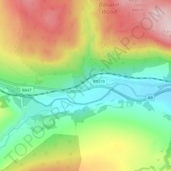
Name: Topografische Karte Pitagowan, Höhe, Relief.
Durchschnittliche Höhe: 269 m
Minimale Höhe: 139 m
Maximale Höhe: 451 m
Spenden
Rüsten Sie sich für Ihr nächstes Abenteuer:
Als Amazon-Partner erhält diese Website eine Provision für qualifizierte Käufe, ohne zusätzliche Kosten für Sie.
Andere topografische Karten
Klicken Sie auf eine Karte, um ihre Topografie, ihre Höhe und ihr Relief anzuzeigen.
Ochil Hills
United Kingdom > Scotland > Perth and Kinross > Auchterarder
Durchschnittliche Höhe: 235 m
Loch Rannoch
United Kingdom > Scotland > Perth and Kinross > Kinloch Rannoch
Durchschnittliche Höhe: 469 m
Spenden
Rüsten Sie sich für Ihr nächstes Abenteuer:
Als Amazon-Partner erhält diese Website eine Provision für qualifizierte Käufe, ohne zusätzliche Kosten für Sie.
Loch Tay
United Kingdom > Scotland > Perth and Kinross > Kenmore
In the Early Medieval period people began to cultivate the higher elevations of the hills around the loch. The Macnabs, the Menzies, the Drummonds, the Napiers, the Haldanes, the MacGregors and the Robertsons of Carwhin and Strowan all owned land around the loch but little remains of their possible…
Durchschnittliche Höhe: 460 m
Dupplin Castle
United Kingdom > Scotland > Perth and Kinross > Forteviot > Aberdalgie
Durchschnittliche Höhe: 74 m
Spenden
Rüsten Sie sich für Ihr nächstes Abenteuer:
Als Amazon-Partner erhält diese Website eine Provision für qualifizierte Käufe, ohne zusätzliche Kosten für Sie.
Glen Shee
United Kingdom > Scotland > Perth and Kinross > Spittal of Glenshee
The A93 road, part of General Wade's military road from Perth to Fort George, runs north through the glen and on into Glen Beag, where it crosses the Cairnwell Pass, which at an elevation of 2,200 feet (670 metres) is the highest public road in the UK. The road climbing to the summit is now wide and straight…
Durchschnittliche Höhe: 387 m
Loch Leven National Nature Reserve
United Kingdom > Scotland > Perth and Kinross > Kinross
Durchschnittliche Höhe: 119 m
Spenden
Rüsten Sie sich für Ihr nächstes Abenteuer:
Als Amazon-Partner erhält diese Website eine Provision für qualifizierte Käufe, ohne zusätzliche Kosten für Sie.
Burleigh Castle
United Kingdom > Scotland > Perth and Kinross > Milnathort
Durchschnittliche Höhe: 120 m
Elcho Castle
United Kingdom > Scotland > Perth and Kinross > Perth > Rhynd
Durchschnittliche Höhe: 38 m
The Birks of Aberfeldy
United Kingdom > Scotland > Perth and Kinross > Aberfeldy
Durchschnittliche Höhe: 222 m
Spenden
Rüsten Sie sich für Ihr nächstes Abenteuer:
Als Amazon-Partner erhält diese Website eine Provision für qualifizierte Käufe, ohne zusätzliche Kosten für Sie.
Loch Tummel
United Kingdom > Scotland > Perth and Kinross > Tummel Bridge
Durchschnittliche Höhe: 365 m
Spenden
Rüsten Sie sich für Ihr nächstes Abenteuer:
Als Amazon-Partner erhält diese Website eine Provision für qualifizierte Käufe, ohne zusätzliche Kosten für Sie.
River Tummel
United Kingdom > Scotland > Perth and Kinross > Kinloch Rannoch
Durchschnittliche Höhe: 357 m
Spenden
Rüsten Sie sich für Ihr nächstes Abenteuer:
Als Amazon-Partner erhält diese Website eine Provision für qualifizierte Käufe, ohne zusätzliche Kosten für Sie.
Loch of the Lowes
United Kingdom > Scotland > Perth and Kinross > Dunkeld
Durchschnittliche Höhe: 138 m
Spenden
Rüsten Sie sich für Ihr nächstes Abenteuer:
Als Amazon-Partner erhält diese Website eine Provision für qualifizierte Käufe, ohne zusätzliche Kosten für Sie.
Loch Monzievaird
United Kingdom > Scotland > Perth and Kinross > Crieff > Monzievaird
Durchschnittliche Höhe: 121 m
Spenden
Rüsten Sie sich für Ihr nächstes Abenteuer:
Als Amazon-Partner erhält diese Website eine Provision für qualifizierte Käufe, ohne zusätzliche Kosten für Sie.
Ochil Hills
United Kingdom > Scotland > Perth and Kinross > Auchterarder
Durchschnittliche Höhe: 235 m
Loch Errochty
United Kingdom > Scotland > Perth and Kinross
Loch Errochty is a man made freshwater loch situated within the Perth and Kinross council area at the edge of the Scottish Highlands near the Highland Boundary Fault where the topography changes to lowland.
Durchschnittliche Höhe: 457 m
Spenden
Rüsten Sie sich für Ihr nächstes Abenteuer:
Als Amazon-Partner erhält diese Website eine Provision für qualifizierte Käufe, ohne zusätzliche Kosten für Sie.