
Spenden
Rüsten Sie sich für Ihr nächstes Abenteuer:
Als Amazon-Partner erhält diese Website eine Provision für qualifizierte Käufe, ohne zusätzliche Kosten für Sie.
Topografische Karte Glen Shee
Klicken Sie auf die Karte, um die Höhe anzuzeigen.
Spenden
Rüsten Sie sich für Ihr nächstes Abenteuer:
Als Amazon-Partner erhält diese Website eine Provision für qualifizierte Käufe, ohne zusätzliche Kosten für Sie.
Glen Shee
The A93 road, part of General Wade's military road from Perth to Fort George, runs north through the glen and on into Glen Beag, where it crosses the Cairnwell Pass, which at an elevation of 2,200 feet (670 metres) is the highest public road in the UK. The road climbing to the summit is now wide and straight but until the late 1960s included two notorious hair-pin bends with a 1 in 3 (33%) gradient known as the Devil's Elbow. One of the most spectacular roads in Scotland, this was a favourite subject for postcards. It was so steep that at the bottom buses unloaded passengers who had to walk to the top and until it was rebuilt the AA maintained a well in a layby for overheating engines. Locally the pass is still known simply as "the Elbow". At Dalrulzion, the B950 leads off to Strathardle and Kirkmichael village (4 miles) and at the Lair the B951 leads over into Glenisla. The long established caravan site at Dalrulzion is a favourite with weekenders from Dundee and Fife. Between Finegand and the Lair is the historic Cockstane (Clach Na Coileach), the ancient meeting place of the Clan MacThomas. There is a car park and information board with all the history. Current members of the Clan MacThomas from across the world gather here regularly.
Spenden
Rüsten Sie sich für Ihr nächstes Abenteuer:
Als Amazon-Partner erhält diese Website eine Provision für qualifizierte Käufe, ohne zusätzliche Kosten für Sie.
Über diese Karte
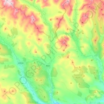
Name: Topografische Karte Glen Shee, Höhe, Relief.
Durchschnittliche Höhe: 387 m
Minimale Höhe: 134 m
Maximale Höhe: 867 m
Spenden
Rüsten Sie sich für Ihr nächstes Abenteuer:
Als Amazon-Partner erhält diese Website eine Provision für qualifizierte Käufe, ohne zusätzliche Kosten für Sie.