
Topografische Karte Täsch
Interaktive Karte
Klicken Sie auf die Karte, um die Höhe anzuzeigen.
Über diese Karte
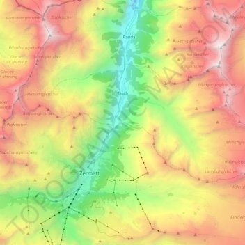
Name: Topografische Karte Täsch, Höhe, Relief.
Ort: Täsch, Visp, Wallis, 3929, Switzerland (46.01622 7.69006 46.08467 7.89458)
Durchschnittliche Höhe: 2.811 m
Minimale Höhe: 1.284 m
Maximale Höhe: 4.532 m
Andere topografische Karten
Klicken Sie auf eine Karte, um ihre Topografie, ihre Höhe und ihr Relief anzuzeigen.
Saas-Almagell
Switzerland > Wallis > Visp
Saas-Almagell, Visp, Wallis, 3905, Switzerland
Durchschnittliche Höhe: 2.830 m
Zermatt
Switzerland > Wallis > Visp
Zermatt, Visp, Wallis, 3920, Switzerland
Durchschnittliche Höhe: 2.921 m
Monte Rosa
Switzerland > Wallis > Visp > Zermatt
Monte Rosa, Zermatt, Visp, Wallis, 3920, Switzerland
Durchschnittliche Höhe: 4.033 m
Matterhorn
Switzerland > Wallis > Visp > Zermatt
Matterhorn, Zermatt, Visp, Wallis, 3920, Switzerland
Durchschnittliche Höhe: 3.295 m
Randa
Switzerland > Wallis > Visp
Randa, Visp, Wallis, 3928, Switzerland
Durchschnittliche Höhe: 2.804 m
Gornergrat
Switzerland > Wallis > Visp > Zermatt
Gornergrat, Gornergrat - Hohtälli, Zermatt, Visp, Wallis, 3920, Switzerland
Durchschnittliche Höhe: 2.768 m