
Topografische Karte Monte Rosa
Interaktive Karte
Klicken Sie auf die Karte, um die Höhe anzuzeigen.
Über diese Karte
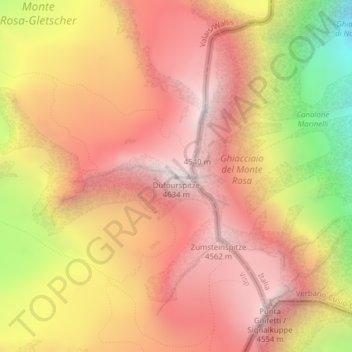
Name: Topografische Karte Monte Rosa, Höhe, Relief.
Ort: Monte Rosa, Zermatt, Visp, Wallis, 3920, Switzerland (45.93686 7.86670 45.93696 7.86680)
Durchschnittliche Höhe: 4.033 m
Minimale Höhe: 3.037 m
Maximale Höhe: 4.619 m
The peak is distinguished by the name Dufourspitze (in German, lit. Dufour Peak; French: Pointe Dufour, Italian: Punta Dufour). This replaced the former name Höchste Spitze (English: Highest Peak) that was indicated on the Swiss maps before the Federal Council, on January 28, 1863, decided to rename the mountain in honor of Guillaume-Henri Dufour. Dufour was a Swiss engineer, topographer, co-founder of the Red Cross and army general who led the Sonderbund campaign. This decision followed the completion of the Dufour Map, a series of military topographical maps created under the command of Dufour.
Andere topografische Karten
Klicken Sie auf eine Karte, um ihre Topografie, ihre Höhe und ihr Relief anzuzeigen.
Matterhorn
Switzerland > Wallis > Visp > Zermatt
Matterhorn, Zermatt, Visp, Wallis, 3920, Switzerland
Durchschnittliche Höhe: 3.295 m
Gornergrat
Switzerland > Wallis > Visp > Zermatt
Gornergrat, Gornergrat - Hohtälli, Zermatt, Visp, Wallis, 3920, Switzerland
Durchschnittliche Höhe: 2.768 m