
Topografische Karte Zermatt
Interaktive Karte
Klicken Sie auf die Karte, um die Höhe anzuzeigen.
Zermatt
Zermatt () ist eine politische Gemeinde und eine Burgergemeinde mit einem Burgerrat des Bezirks Visp sowie eine Pfarrgemeinde des Dekanats Visp im Schweizer Kanton Wallis. Bevölkerungsmässig ist Zermatt nach Visp zweitgrösster Ort im Bezirk Visp und liegt im Mattertal auf einer Höhe von zirka 1610 m am Nordostfuss des Matterhorns. Zermatt ist ein Bergsteigerzentrum und dank des Matterhorns und seines Wintersport- und Wandergebietes ein bekannter Ferienort der Schweiz.
Über diese Karte
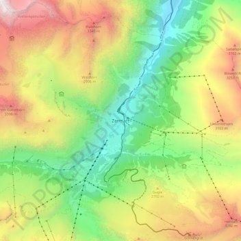
Name: Topografische Karte Zermatt, Höhe, Relief.
Ort: Zermatt, Visp, Wallis, 3920, Schweiz (45.98121 7.70925 46.06121 7.78925)
Durchschnittliche Höhe: 2.469 m
Minimale Höhe: 1.443 m
Maximale Höhe: 3.894 m