
Topografische Karte Mizoram
Interaktive Karte
Klicken Sie auf die Karte, um die Höhe anzuzeigen.
Über diese Karte
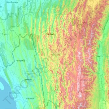
Name: Topografische Karte Mizoram, Höhe, Relief.
Ort: Mizoram, India (21.94126 92.26022 24.52120 93.43737)
Durchschnittliche Höhe: 544 m
Minimale Höhe: 0 m
Maximale Höhe: 2.637 m
Mizoram is a land of rolling hills, valleys, rivers and lakes. As many as 21 major hill ranges or peaks of different heights run through the length and breadth of the state, with plains scattered here and there. The average height of the hills to the west of the state is about 1,000 metres (3,300 ft). These gradually rise up to 1,300 metres (4,300 ft) to the east. Some areas, however, have higher ranges which go up to a height of over 2,000 metres (6,600 ft). Phawngpui Tlang also known as the Blue Mountain, situated in the southeastern part of the state, is the highest peak in Mizoram at 2,210 metres (7,250 ft). About 76% of the state is covered by forests, 8% is fallows land, 3% is barren and considered uncultivable area, while cultivable and sown area constitutes the rest. Slash-and-burn or jhum cultivation, though discouraged, remains in practice in Mizoram and affects its topography. A report by Ministry of Environment, Forest and Climate Change in 2021 states that Mizoram has the highest forest cover as a percentage of its geographical area of any Indian state, being 84.53% forest.
Andere topografische Karten
Klicken Sie auf eine Karte, um ihre Topografie, ihre Höhe und ihr Relief anzuzeigen.
Bengaluru
India > Karnataka > Bangalore North
Bengaluru, Bangalore North, Bengaluru Urban District, Karnataka, India
Durchschnittliche Höhe: 881 m
Chennai
India > Tamil Nadu > Chennai
Chennai, Chennai District, Tamil Nadu, India
Durchschnittliche Höhe: 8 m
3d
India > Rajasthan > Ganganagar Tehsil > 1 LNP
3d, 1 LNP, Ganganagar Tehsil, Sri Ganganagar District, Rajasthan, India
Durchschnittliche Höhe: 178 m
Nanded
India > Maharashtra > Nanded
Nanded, Nanded District, Maharashtra, 431600, India
Durchschnittliche Höhe: 376 m
Kolkata
Kolkata, Kolkata District, West Bengal, 700073, India
Durchschnittliche Höhe: 5 m
Mysuru
India > Karnataka > Mysuru taluk
Mysuru, Mysuru taluk, Mysuru District, Karnataka, 570001, India
Durchschnittliche Höhe: 727 m
Shimla
India > Himachal Pradesh > Shimla (urban)
Shimla, Shimla (urban), Shimla District, Himachal Pradesh, 171001, India
Durchschnittliche Höhe: 1.557 m
Thiruvananthapuram
India > Kerala > Thiruvananthapuram
Thiruvananthapuram, Thiruvananthapuram District, Kerala, 695001, India
Durchschnittliche Höhe: 33 m
Coimbatore
India > Tamil Nadu > Coimbatore North
Coimbatore, Coimbatore North, Coimbatore District, Tamil Nadu, 641001, India
Durchschnittliche Höhe: 452 m
Bachupally mandal
Bachupally mandal, Medchal–Malkajgiri District, Telangana, 500090, India
Durchschnittliche Höhe: 593 m
Jaipur
India > Rajasthan > Jaipur Tehsil
Jaipur, Jaipur Municipal Corporation, Jaipur Tehsil, Jaipur District, Rajasthan, 302001, India
Durchschnittliche Höhe: 408 m
Jagara
India > Karnataka > Chikkamagaluru taluku
Jagara, Chikkamagaluru taluku, Chikkamagaluru District, Karnataka, India
Durchschnittliche Höhe: 824 m
Limpiya Pass
India > Uttarakhand > Dharchula Tehsil (India)
Limpiya Pass, Dharchula Tehsil (India), Pithoragarh District, Uttarakhand, India
Durchschnittliche Höhe: 5.393 m
Gurjal
India > Telangana > Gandhari mandal
Gurjal, Gandhari mandal, Kamareddy District, Telangana, India
Durchschnittliche Höhe: 543 m
Hosur
India > Tamil Nadu > Hosur
Hosur, Krishnagiri District, Tamil Nadu, 635109, India
Durchschnittliche Höhe: 859 m
Western Ghats
Western Ghats, Idukki, Kerala, 685614, India
Durchschnittliche Höhe: 2.225 m
Kallooppara
India > Kerala > Mallappally
Kallooppara, Mallappally, Pathanamthitta District, Kerala, 689583, India
Durchschnittliche Höhe: 19 m
Patna
India > Bihar > Patna Rural
Patna, Patna Rural, Patna District, Bihar, 800001, India
Durchschnittliche Höhe: 51 m
Pune
India > Maharashtra > Pune City > Pune
Pune, Pune City, Pune District, Maharashtra, 411001, India
Durchschnittliche Höhe: 641 m
Sarati
India > Maharashtra > Sakoli Taluka
Sarati, Sakoli Taluka, Bhandara District, Maharashtra, India
Durchschnittliche Höhe: 253 m
Triprayar Beach
India > Kerala > Chavakkad > Thriprayar
Triprayar Beach, Thriprayar, Chavakkad, Thrissur District, Kerala, India
Durchschnittliche Höhe: 4 m
North Sentinel Island
India > Andaman and Nicobar Islands > Ferrargunj
North Sentinel Island, Ferrargunj, South Andaman District, Andaman and Nicobar Islands, India
Durchschnittliche Höhe: 20 m
Whitefield
India > Karnataka > Bangalore East > Bengaluru
Whitefield, Bengaluru, Bangalore East, Bengaluru Urban District, Karnataka, 560066, India
Durchschnittliche Höhe: 875 m