
Spenden
Rüsten Sie sich für Ihr nächstes Abenteuer:
Als Amazon-Partner erhält diese Website eine Provision für qualifizierte Käufe, ohne zusätzliche Kosten für Sie.
Topografische Karte Uttar Pradesh
Klicken Sie auf die Karte, um die Höhe anzuzeigen.
Spenden
Rüsten Sie sich für Ihr nächstes Abenteuer:
Als Amazon-Partner erhält diese Website eine Provision für qualifizierte Käufe, ohne zusätzliche Kosten für Sie.
Uttar Pradesh
Uttar Pradesh, with a total area of 243,290 square kilometres (93,935 sq mi), is India's fourth-largest state in terms of land area and is roughly of same size as United Kingdom. It is situated on the northern spout of India and shares an international boundary with Nepal. The Himalayas border the state on the north, but the plains that cover most of the state are distinctly different from those high mountains. The larger Gangetic Plain region is in the north; it includes the Ganges-Yamuna Doab, the Ghaghra plains, the Ganges plains and the Terai. The smaller Vindhya Range and plateau region are in the south. It is characterised by hard rock strata and a varied topography of hills, plains, valleys and plateaus. The Bhabhar tract gives place to the terai area which is covered with tall elephant grass and thick forests interspersed with marshes and swamps. The sluggish rivers of the bhabhar deepen in this area, their course running through a tangled mass of thick undergrowth. The terai runs parallel to the bhabhar in a thin strip. The entire alluvial plain is divided into three sub-regions. The first in the eastern tract consisting of 14 districts which are subject to periodical floods and droughts and have been classified as scarcity areas. These districts have the highest density of population which gives the lowest per capita land. The other two regions, the central and the western, are comparatively better with a well-developed irrigation system. They suffer from waterlogging and large-scale user tracts. In addition, the area is fairly arid. The state has more than 32 large and small rivers; of them, the Ganga, Yamuna, Saraswati, Sarayu, Betwa, and Ghaghara are larger and of religious importance in Hinduism.
Spenden
Rüsten Sie sich für Ihr nächstes Abenteuer:
Als Amazon-Partner erhält diese Website eine Provision für qualifizierte Käufe, ohne zusätzliche Kosten für Sie.
Über diese Karte
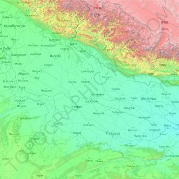
Name: Topografische Karte Uttar Pradesh, Höhe, Relief.
Ort: Uttar Pradesh, India (23.87063 77.08388 30.40638 84.63451)
Durchschnittliche Höhe: 954 m
Minimale Höhe: 47 m
Maximale Höhe: 7.878 m
Spenden
Rüsten Sie sich für Ihr nächstes Abenteuer:
Als Amazon-Partner erhält diese Website eine Provision für qualifizierte Käufe, ohne zusätzliche Kosten für Sie.
Andere topografische Karten
Klicken Sie auf eine Karte, um ihre Topografie, ihre Höhe und ihr Relief anzuzeigen.
Lucknow
India > Uttar Pradesh > Lucknow
Lucknow stands at an elevation of approximately 123 metres (404 ft) above sea level. The city had an area of 402 km2 (155 square miles) until December 2019, when 88 villages were added to the municipal limits and the area increased to 631 km2 (244 square miles). Bounded on the east by Barabanki, on the west by…
Durchschnittliche Höhe: 120 m
Spenden
Rüsten Sie sich für Ihr nächstes Abenteuer:
Als Amazon-Partner erhält diese Website eine Provision für qualifizierte Käufe, ohne zusätzliche Kosten für Sie.
Mysuru
India > Karnataka > Mysuru taluk
Mysore (/maɪˈsɔːr/ (listen)), officially Mysuru ([ˈmaɪˈsuːɾu] (listen)), is a city in the southern part of the state of Karnataka, India. Mysore city is geographically located between 12° 18′ 26″ north latitude and 76° 38′ 59″ east longitude. It is located at an altitude of 770 m (2,530 ft)…
Durchschnittliche Höhe: 727 m
Ludhiana
India > Punjab > Ludhiana (West) Tahsil
Ludhiana is located at 30°54′N 75°51′E / 30.9°N 75.85°E / 30.9; 75.85. It has an average elevation of 244 metres (801 ft). Ludhiana City, to its residents, consists of the Old City and the New City. The new city primarily consists of the Civil Lines area which was historically known as the…
Durchschnittliche Höhe: 247 m
Maharashtra
Maharashtra is the third largest state by area in India. The Western Ghats better known as Sahyadri, are a hilly range running parallel to the coast, at an average elevation of 1,200 metres (4,000 ft). Kalsubai, a peak in the Sahyadris, near Nashik city is the highest elevated point in Maharashtra. To the west…
Durchschnittliche Höhe: 478 m
Spenden
Rüsten Sie sich für Ihr nächstes Abenteuer:
Als Amazon-Partner erhält diese Website eine Provision für qualifizierte Käufe, ohne zusätzliche Kosten für Sie.
Navi Mumbai
India > Maharashtra > Thane > Navi Mumbai
Navi Mumbai (Marathi pronunciation: , also known by its former name New Bombay), is a planned city off the west coast of the Indian state of Maharashtra in Konkan division. The city is divided into two parts, North Navi Mumbai and South Navi Mumbai, for the individual development of Panvel Mega City, which…
Durchschnittliche Höhe: 30 m
Spenden
Rüsten Sie sich für Ihr nächstes Abenteuer:
Als Amazon-Partner erhält diese Website eine Provision für qualifizierte Käufe, ohne zusätzliche Kosten für Sie.
Mumbai
Mumbai lies at the mouth of the Ulhas River on the western coast of India, in the coastal region known as the Konkan. It sits on Salsette Island (Sashti Island), which it partially shares with the Thane district. Mumbai is bounded by the Arabian Sea to the west. Many parts of the city lie just above sea level,…
Durchschnittliche Höhe: 13 m
Lansdowne
India > Uttarakhand > Lansdowne
Lansdowne is a quaint hill station in the Pauri Garhwal district of Uttarakhand, India. Lodged in the picturesque surroundings of the Himalayan ranges, it lies at an elevation of approximately 1,700 meters (5,577 feet) above sea level. The town is about 45 kilometers (28 miles) from the district headquarters,…
Durchschnittliche Höhe: 1.140 m
Spenden
Rüsten Sie sich für Ihr nächstes Abenteuer:
Als Amazon-Partner erhält diese Website eine Provision für qualifizierte Käufe, ohne zusätzliche Kosten für Sie.
Gokak
India > Karnataka > Gokak taluku
Gokak is second biggest city after Belgaum city in Belgaum district and is surrounded by the Western Ghats. The Ghataprabha River, which has water almost throughout the year, is the chief source of agricultural and drinking water for local people living in the surrounding villages. It has an average elevation…
Durchschnittliche Höhe: 593 m
Spenden
Rüsten Sie sich für Ihr nächstes Abenteuer:
Als Amazon-Partner erhält diese Website eine Provision für qualifizierte Käufe, ohne zusätzliche Kosten für Sie.
Mussoorie
India > Uttarakhand > Dehradun
Mussoorie is at an average altitude of 2,005 metres (6,578 ft). To the northeast are the Himalayan snow ranges, and to the south, the Doon Valley and Shiwalik ranges. The second highest point is the original Lal Tibba in Landour, with a height of over 2,275 m (7,464 ft). Mussoorie is popularly known as The…
Durchschnittliche Höhe: 1.594 m
Daulat Beg Oldi
Daulat Beg Oldi (DBO) lies at the northeastern corner of the Karakoram Range, at the northern edge of Depsang Plains at an elevation of 5,100 metres (16,700 ft). The international border with China is 8 km to the north and the Line of Actual Control with Chinese-controlled Aksai Chin is 9 km to the east. Other…
Durchschnittliche Höhe: 5.085 m
Spenden
Rüsten Sie sich für Ihr nächstes Abenteuer:
Als Amazon-Partner erhält diese Website eine Provision für qualifizierte Käufe, ohne zusätzliche Kosten für Sie.
Chennai
Chennai is located on the south–eastern coast of India in the north–eastern part of Tamil Nadu on a flat coastal plain known as the Eastern Coastal Plains. Its average elevation is around 6.7 metres (22 ft), and its highest point is 60 m (200 ft). Chennai is 2,184 kilometres (1,357 mi) south of Delhi,…
Durchschnittliche Höhe: 7 m
Western Ghats
The range starts near south of the Tapti river and runs approximately 1,600 km (990 mi) through the states of Gujarat, Maharashtra, Karnataka, Goa, Kerala and Tamil Nadu ending at Marunthuvazh Malai, Swamithope near the southern tip of India. These hills cover 160,000 km2 (62,000 sq mi) and form the catchment…
Durchschnittliche Höhe: 2.225 m
Spenden
Rüsten Sie sich für Ihr nächstes Abenteuer:
Als Amazon-Partner erhält diese Website eine Provision für qualifizierte Käufe, ohne zusätzliche Kosten für Sie.
Spenden
Rüsten Sie sich für Ihr nächstes Abenteuer:
Als Amazon-Partner erhält diese Website eine Provision für qualifizierte Käufe, ohne zusätzliche Kosten für Sie.
Chandannagar
India > West Bengal > Singur
Chandannagar is located at 22°52′N 88°23′E / 22.87°N 88.38°E / 22.87; 88.38. It has an average elevation of 10 metres (33 ft).
Durchschnittliche Höhe: 8 m
Spenden
Rüsten Sie sich für Ihr nächstes Abenteuer:
Als Amazon-Partner erhält diese Website eine Provision für qualifizierte Käufe, ohne zusätzliche Kosten für Sie.
Spenden
Rüsten Sie sich für Ihr nächstes Abenteuer:
Als Amazon-Partner erhält diese Website eine Provision für qualifizierte Käufe, ohne zusätzliche Kosten für Sie.
Spenden
Rüsten Sie sich für Ihr nächstes Abenteuer:
Als Amazon-Partner erhält diese Website eine Provision für qualifizierte Käufe, ohne zusätzliche Kosten für Sie.
Ponmudi
India > Kerala > Nedumangad
Ponmudi (the Golden Peak) is a hill station in the Peringamala gramapanchayath of Trivandrum District of Kerala in India. It is located 22km west of Vithura town, 53 km north-east of Trivandrum City, 78 km south-east of Varkala town and 69 km north-east of Kovalam Beach at an altitude of 1,100 m (3,600 ft).…
Durchschnittliche Höhe: 673 m
Spenden
Rüsten Sie sich für Ihr nächstes Abenteuer:
Als Amazon-Partner erhält diese Website eine Provision für qualifizierte Käufe, ohne zusätzliche Kosten für Sie.
Spenden
Rüsten Sie sich für Ihr nächstes Abenteuer:
Als Amazon-Partner erhält diese Website eine Provision für qualifizierte Käufe, ohne zusätzliche Kosten für Sie.
Chikkanayakanahalli
India > Karnataka > Chikkanayakanahalli taluk
Chikkanayakana-halli is located at 13°25′N 76°37′E / 13.42°N 76.62°E / 13.42; 76.62. It has an average elevation of 804 metres (2,638 ft). It is located on National Highway 150A.
Durchschnittliche Höhe: 811 m
Spenden
Rüsten Sie sich für Ihr nächstes Abenteuer:
Als Amazon-Partner erhält diese Website eine Provision für qualifizierte Käufe, ohne zusätzliche Kosten für Sie.
Warangal
India > Telangana > Warangal mandal
Warangal is located at 18°00′N 79°35′E / 18.0°N 79.58°E / 18.0; 79.58. It has an average elevation of 302 metres (990 feet). It is settled in the eastern part of Deccan Plateau made up of granite rocks and hill formations which left the region barren making the cultivation dependent on…
Durchschnittliche Höhe: 268 m
Udhagamandalam
India > Tamil Nadu > Udhagamandalam
Ooty is situated in the Nilgiri Biosphere Reserve. Many of the forested areas and water bodies are off-limits to most visitors in order to protect this fragile ecosystem. Some areas of the Biosphere Reserve have been earmarked for tourism development, and steps are being undertaken to open these areas to…
Durchschnittliche Höhe: 2.234 m
Spenden
Rüsten Sie sich für Ihr nächstes Abenteuer:
Als Amazon-Partner erhält diese Website eine Provision für qualifizierte Käufe, ohne zusätzliche Kosten für Sie.
Leh
Leh (/ˈlɛ/) (Ladakhi: གླེ) is the joint capital and largest city of Ladakh, a union territory of India. Leh, located in the Leh district, was also the historical capital of the Kingdom of Ladakh, the seat of which was in the Leh Palace, the former residence of the royal family of Ladakh, built in the…
Durchschnittliche Höhe: 4.294 m
Udaipur
India > Rajasthan > Girwa Tehsil
Udaipur is located at 24°31′30″N 73°40′38″E / 24.525049°N 73.677116°E / 24.525049; 73.677116. The city covers an area of 64 km2 (25 sq mi) and lies at an altitude of 598.00 m (1,962 ft) above sea level. It is located in the southern region of Rajasthan, near the Gujarat border. The city…
Durchschnittliche Höhe: 656 m
Lucknow
India > Uttar Pradesh > Lucknow
The city stands at an elevation of approximately 123 metres (404 ft) above sea level. Lucknow city had an area of 402 km2 (155 square miles) till December 2019, when 88 villages were added to the municipal limits and the area increased to 631 km2 (244 square miles). Bounded on the east by Barabanki, on the…
Durchschnittliche Höhe: 120 m
Shimla
Shimla is on the south-western ranges of the Himalayas at 31°37′N 77°06′E / 31.61°N 77.10°E / 31.61; 77.10. It has an average altitude of 2,206 metres (7,238 ft) above mean sea level and extends along a ridge with seven spurs. The city stretches nearly 9.2 kilometres (5.7 mi) from east to west.
Durchschnittliche Höhe: 1.557 m
Spenden
Rüsten Sie sich für Ihr nächstes Abenteuer:
Als Amazon-Partner erhält diese Website eine Provision für qualifizierte Käufe, ohne zusätzliche Kosten für Sie.
Thiruvananthapuram
India > Kerala > Thiruvananthapuram
Thiruvananthapuram is built on seven hills by the seashore and is at 8°30′N 76°54′E / 8.5°N 76.9°E / 8.5; 76.9 on the west coast, near the southern tip of mainland India. The city is on the west coast of India and is bounded by the Laccadive Sea to its west and the Western Ghats to its east.…
Durchschnittliche Höhe: 33 m
Dehradun
India > Uttarakhand > Dehradun
The city of Dehradun mainly lies in Doon Valley and is at a varying height from 410 m (1,350 ft) in Clement Town to above 700 m (2,300 ft) at Malsi which is 15 km (9.3 mi) from the city. However, the average elevation is 450 m (1,480 ft) above sea level. Malsi is the starting point of Lesser Himalayan Range…
Durchschnittliche Höhe: 904 m
Spenden
Rüsten Sie sich für Ihr nächstes Abenteuer:
Als Amazon-Partner erhält diese Website eine Provision für qualifizierte Käufe, ohne zusätzliche Kosten für Sie.
Spenden
Rüsten Sie sich für Ihr nächstes Abenteuer:
Als Amazon-Partner erhält diese Website eine Provision für qualifizierte Käufe, ohne zusätzliche Kosten für Sie.
Dhanbad
India > Jharkhand > Dhanbad-Cum-Kenduadih-Cum-Jagata
Dhanbad has an average elevation of 227 m (745 ft). Its geographical length (extending from north to south) is 15 miles (24 km) and the breadth (stretching across east to West) is 10 miles (16 km). It shares its boundaries with West Bengal in the eastern and southern part, Giridih and Dumka in the North and…
Durchschnittliche Höhe: 212 m
Dhrangadhra
India > Gujarat > Dhrangadhra Taluka
Dhrangadhra is located at 22°59′N 71°28′E / 22.98°N 71.47°E / 22.98; 71.47. It has an average elevation of 64 metres (209 feet).
Durchschnittliche Höhe: 52 m
Khrew
India > Jammu and Kashmir > Pampore
Khrew is located at 34°01′12″N 74°59′24″E / 34.020°N 74.99°E / 34.020; 74.99. It has an average elevation of 1,607 metres (5,272 feet) and is located in the Kashmir valley. The area starts from Babapora to Seer Bagh and from Bathen to Androosa. Also, the foot region is extended to Ladhoo,…
Durchschnittliche Höhe: 1.788 m
Spenden
Rüsten Sie sich für Ihr nächstes Abenteuer:
Als Amazon-Partner erhält diese Website eine Provision für qualifizierte Käufe, ohne zusätzliche Kosten für Sie.
Dahanu
India > Maharashtra > Dahanu Taluka
Dahanu is located at 19°58′N 72°44′E / 19.97°N 72.73°E / 19.97; 72.73. It has an average elevation of 9.89 metres. To the west of the town is the coast of the Arabian Sea while the east is lined with the Sahyadri ranges. This combination has made Dahanu a tourist destination. Sprawling Chickoo…
Durchschnittliche Höhe: 9 m
Sojat
India > Rajasthan > Sojat Tehsil
Sojat is located at 25°55′N 73°40′E / 25.92°N 73.67°E / 25.92; 73.67. It has an average elevation of 257 metres (843 feet). The whole region lies on the way of "Aravali hills range" which is the oldest hill range in India.
Durchschnittliche Höhe: 270 m
Spenden
Rüsten Sie sich für Ihr nächstes Abenteuer:
Als Amazon-Partner erhält diese Website eine Provision für qualifizierte Käufe, ohne zusätzliche Kosten für Sie.
Sanathnagar Industrial Estate Park
India > Telangana > Balanagar mandal > Hyderabad
Durchschnittliche Höhe: 543 m
Spenden
Rüsten Sie sich für Ihr nächstes Abenteuer:
Als Amazon-Partner erhält diese Website eine Provision für qualifizierte Käufe, ohne zusätzliche Kosten für Sie.
Bahraich
India > Uttar Pradesh > Bahraich
It has an average elevation of 126 metres (413 feet). Bahraich has a warm humid subtropical climate with hot summers from April to July. The rainy season is from July to mid-September when Bahraich gets an average rainfall from the south-west monsoon winds, and occasionally frontal rainfall will occur in…
Durchschnittliche Höhe: 120 m
Spenden
Rüsten Sie sich für Ihr nächstes Abenteuer:
Als Amazon-Partner erhält diese Website eine Provision für qualifizierte Käufe, ohne zusätzliche Kosten für Sie.
Gopeshwar
India > Uttarakhand > Chamoli Tehsil
Gopeshwar is located at 30°25′N 79°20′E / 30.42°N 79.33°E / 30.42; 79.33. It has an average elevation of 1,450 m (4,760 ft). Gopeshwar is 8.4 km (5.2 mi) away from Chamoli which is located on the banks of Alaknanda river and along NH 58. Gopeshwar is able to captivate any visitor with its…
Durchschnittliche Höhe: 1.566 m
Spenden
Rüsten Sie sich für Ihr nächstes Abenteuer:
Als Amazon-Partner erhält diese Website eine Provision für qualifizierte Käufe, ohne zusätzliche Kosten für Sie.
Western Ghats
The range starts near south of the Tapti river and runs approximately 1,600 km (990 mi) through the states of Gujarat, Maharashtra, Karnataka, Goa, Kerala and Tamil Nadu ending at Marunthuvazh Malai near the southern tip of India. These hills cover 160,000 km2 (62,000 sq mi) and form the catchment area for…
Durchschnittliche Höhe: 2.225 m
Spenden
Rüsten Sie sich für Ihr nächstes Abenteuer:
Als Amazon-Partner erhält diese Website eine Provision für qualifizierte Käufe, ohne zusätzliche Kosten für Sie.
Badami
India > Karnataka > Badami taluku
Badami is located at 15°55′N 75°41′E / 15.92°N 75.68°E / 15.92; 75.68. It has an average elevation of 586 metres (1922 ft). It is located at the mouth of a ravine between two rocky hills and surrounds Agastya tirtha water reservoir on the three other sides. The total area of the town is 10.3…
Durchschnittliche Höhe: 587 m
Thiruvananthapuram
India > Kerala > Thiruvananthapuram
Thiruvananthapuram is built on seven hills by the seashore and is at 8°30′N 76°54′E / 8.5°N 76.9°E / 8.5; 76.9 on the west coast, near the southern tip of mainland India. The city is on the west coast of India and is bounded by the Laccadive Sea to its west and the Western Ghats to its east.…
Durchschnittliche Höhe: 33 m
Angul
Angul (also known as Anugul) is a town and a municipality and the headquarters of Angul district in the state of Odisha, India. Angul has an average elevation of 195 m (640 ft) above sea level. The total geographical area of the district is 6232 km2. From the point of view of area, it stands 11th among the 30…
Durchschnittliche Höhe: 121 m
Vijayawada
India > Andhra Pradesh > Vijayawada (Urban)
Vijayawada lies on the banks of Krishna river, covered by hills and canals. and at an altitude of 11 m (36 ft) above sea level. Three canals originating from the north side of the Prakasam Barrage reservoir — Eluru, Bandar, and Ryves — flow through the city.
Durchschnittliche Höhe: 37 m
Spenden
Rüsten Sie sich für Ihr nächstes Abenteuer:
Als Amazon-Partner erhält diese Website eine Provision für qualifizierte Käufe, ohne zusätzliche Kosten für Sie.