
Topografische Karte Kerala
Klicken Sie auf die Karte, um die Höhe anzuzeigen.
Kerala
Kerala was alternatively called Malabar in the foreign trade circles. Earlier, the term Malabar had also been used to denote Tulu Nadu and Kanyakumari which lie contiguous to Kerala on the southwestern coast of India, in addition to the modern state of Kerala. The people of Malabar were known as Malabars. Until the arrival of the East India Company, the term Malabar was used as a general name for Kerala, along with the term Kerala. From the time of Cosmas Indicopleustes (6th century CE) itself, the Arab sailors used to call Kerala as Male. The first element of the name, however, is attested already in the Topography written by Cosmas Indicopleustes. This mentions a pepper emporium called Male, which clearly gave its name to Malabar ('the country of Male'). The name Male is thought to come from the Malayalam word Mala ('hill'). Al-Biruni (973–1048 CE) is the first known writer to call this country Malabar. Authors such as Ibn Khordadbeh and Al-Baladhuri mention Malabar ports in their works. The Arab writers had called this place Malibar, Manibar, Mulibar, and Munibar. Malabar is reminiscent of the word Malanad which means the land of hills. According to William Logan, the word Malabar comes from a combination of the Malayalam word Mala (hill) and the Persian/Arabic word Barr (country/continent).
Über diese Karte
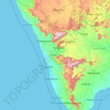
Name: Topografische Karte Kerala, Höhe, Relief.
Ort: Kerala, India (8.29353 74.86407 12.79606 77.41236)
Durchschnittliche Höhe: 251 m
Minimale Höhe: -4 m
Maximale Höhe: 2.557 m
Andere topografische Karten
Klicken Sie auf eine Karte, um ihre Topografie, ihre Höhe und ihr Relief anzuzeigen.
Vadodara
India > Gujarat > Vadodara Rural Taluka
Vadodara is located at 22°18′N 73°11′E / 22.30°N 73.19°E / 22.30; 73.19 in western India at an elevation of 39 metres (128 ft). It is the tenth-largest city in India with an area of 400 square kilometres (150 sq mi) and a population of 3.5 million, according to the 2010–11 census. The city…
Durchschnittliche Höhe: 36 m
Surat
India > Gujarat > Katargam Taluka > Surat
Surat is a port city situated on the banks of the Tapi river. Damming of the Tapi caused the original port facilities to close; the nearest port is now in the Magadalla and Hazira area of Surat Metropolitan Region.It has famous beach called 'Dumas Beach' located in Hazira. The city is located at 21°10′N…
Durchschnittliche Höhe: 11 m
Thiruvananthapuram
India > Kerala > Thiruvananthapuram
Thiruvananthapuram is built on seven hills by the seashore and is at 8°30′N 76°54′E / 8.5°N 76.9°E / 8.5; 76.9 on the west coast, near the southern tip of mainland India. The city is on the west coast of India and is bounded by the Laccadive Sea to its west and the Western Ghats to its east.…
Durchschnittliche Höhe: 33 m
Maharashtra
Maharashtra is the third largest state by area in India. The Western Ghats better known as Sahyadri, are a hilly range running parallel to the coast, at an average elevation of 1,200 metres (4,000 ft). Kalsubai, a peak in the Sahyadris, near Nashik city is the highest elevated point in Maharashtra. To the west…
Durchschnittliche Höhe: 478 m
Kottayam
Kottayam has an average elevation of 3 metres (9.8 ft) above sea level. and is situated in the basin of the Meenachil River and in the basin of the Vembanad backwaters, which are formed from several streams in the Western Ghats in Idukki district. According to the division of places in Kerala based on…
Durchschnittliche Höhe: 19 m
Vadodara
India > Gujarat > Vadodara Rural Taluka
Vadodara is located at 22°18′N 73°11′E / 22.30°N 73.19°E / 22.30; 73.19 in western India at an elevation of 39 metres (128 ft). It is the tenth-largest city in India with an area of 400 square kilometres (150 sq mi) and a population of 3.5 million, according to the 2010–11 census. The city…
Durchschnittliche Höhe: 36 m
Rajkot
India > Gujarat > Rajkot East Taluka
Rajkot is located at 22°18′N 70°47′E / 22.3°N 70.78°E / 22.3; 70.78. It has an average elevation of 128 metres (420 ft). The city is located on the bank of Aji River and Nyari River which remains dry except the monsoon months of July to September. The city is spread in the area of 170.00 km².
Durchschnittliche Höhe: 141 m
Kargil
India > Ladakh > Kargil tehsil
Kargil has an average elevation of 2,676 metres (8,780 feet), and is situated along the banks of the Suru River (Indus). The town of Kargil is located 205 km (127 mi) from Srinagar, facing the Northern Areas across the LOC. Like other areas in the Himalayas, Kargil has a temperate climate. Summers are hot with…
Durchschnittliche Höhe: 3.262 m
Thrissur
Thrissur is the headquarters of Thrissur district, in the centre of the Indian state of Kerala. The city is 75 km north-east of Kochi, 133 km south-west of Coimbatore, 124 km south-east of Kozhikode and 151 km north of Changanacherry. The city is located in a hillock called Thekkinkadu Maidan which is the…
Durchschnittliche Höhe: 36 m
Mysuru
India > Karnataka > Mysuru taluk
Mysore (/maɪˈsɔːr/ (listen)), officially Mysuru ([ˈmaɪˈsuːɾu] (listen)), is a city in the southern part of the state of Karnataka, India. Mysore city is geographically located between 12° 18′ 26″ north latitude and 76° 38′ 59″ east longitude. It is located at an altitude of 770 m (2,530 ft)…
Durchschnittliche Höhe: 727 m
Salem
Salem is located at 11°40′N 78°08′E / 11.67°N 78.14°E / 11.67; 78.14, at an average elevation of 278 m (912 ft). The city is surrounded by hills: Nagaramalai on the north, Jarugumalai on the south, Kanjamalai on the west, Godumalai on the east and the Shevaroy Hills on the northeast.…
Durchschnittliche Höhe: 418 m
Nagarjun Sagar Right Canal
India > Andhra Pradesh > Macherla > Javuk Thanda
Durchschnittliche Höhe: 180 m
Tiruvannamalai
India > Tamil Nadu > Tiruvannamalai > Tiruvannamalai
Located on the foothills of Annamalai hills, Tiruvannamalai has been ruled by the Pallavas, the Medieval Cholas, the Later Cholas, Hoysalas, the Vijayanagar Empire, the Carnatic kingdom, Tipu Sultan, and the British. It served as the capital of the Hoysalas. The town is built around the Annamalaiyar Temple…
Durchschnittliche Höhe: 202 m
Aluva
Aluva Railway Station (IR Code: AWY) is a grade-A railway station in Kerala, and is the third busiest railway station in Kochi after Ernakulam Junction railway station and Ernakulam Town railway station. All passenger and express trains bound to southern Kerala have a stop at it. People travelling from the…
Durchschnittliche Höhe: 11 m
Thiruvananthapuram
India > Kerala > Thiruvananthapuram
Thiruvananthapuram is built on seven hills by the seashore and is at 8°30′N 76°54′E / 8.5°N 76.9°E / 8.5; 76.9 on the west coast, near the southern tip of mainland India. The city is on the west coast of India and is bounded by the Laccadive Sea to its west and the Western Ghats to its east.…
Durchschnittliche Höhe: 33 m
Visakhapatnam
India > Andhra Pradesh > Visakhapatnam Urban
The city is situated between the Eastern Ghats and the Bay of Bengal. The city coordinates lies between 17.7041 N and 83.2977 E. The city's area is 682 km2. The average elevation is 45 metres. Visakhpatnam is situated in Coastal Andhra Region.
Durchschnittliche Höhe: 35 m
Anand
India > Gujarat > Anand City Taluka
Anand is located at 22°34′N 72°56′E / 22.57°N 72.93°E / 22.57; 72.93. It has an average elevation of 39 metres (127 feet). The city has an area of 22.7 square kilometres, and the urban area of Anand City is 172 square kilometres including 25 villages around the city.
Durchschnittliche Höhe: 40 m
Madurai
India > Tamil Nadu > Madurai
Madurai is located at 9°56′N 78°07′E / 9.93°N 78.12°E / 9.93; 78.12. It has an average elevation of 101 metres. The city of Madurai lies on the flat and fertile plain of the river Vaigai, which runs in the northwest-southeast direction through the city, dividing it into two almost equal…
Durchschnittliche Höhe: 138 m
Leh
Leh (/ˈlɛ/) (Ladakhi: གླེ) is the joint capital and largest city of Ladakh, a union territory of India. Leh, located in the Leh district, was also the historical capital of the Kingdom of Ladakh, the seat of which was in the Leh Palace, the former residence of the royal family of Ladakh, built in the…
Durchschnittliche Höhe: 4.294 m
Pavagadh
India > Gujarat > Halol Taluka > Manchi Haveli, Pavagadh
Pavagadh is the gateway to Panchmahal. The locations of hilly areas around Halol provide good scenery. Pavagadh Hill has total height of 822 meters and you can find many scenic trails to climb including waterfalls during monsoon time. The plateau at an altitude of 490 meters is known as Machi Haveli. The bus…
Durchschnittliche Höhe: 401 m
Mumbai
Mumbai lies at the mouth of the Ulhas River on the western coast of India, in the coastal region known as the Konkan. It sits on Salsette Island (Sashti Island), which it partially shares with the Thane district. Mumbai is bounded by the Arabian Sea to the west. Many parts of the city lie just above sea level,…
Durchschnittliche Höhe: 13 m
Gangaikondan
India > Tamil Nadu > Manur
Gangaikondan is located at 8°51′N 77°47′E / 8.85°N 77.78°E / 8.85; 77.78. It has an average elevation of 47 metres (154 feet).
Durchschnittliche Höhe: 44 m
Surat
India > Gujarat > Katargam Taluka
Surat is a port city situated on the banks of the Tapi river. After dams were built, water flow in Tapi deceased causing the original port facilities to close. The nearest port is now in the Magadalla and Hazira area of Surat Metropolitan Region. It has a famous beach called 'Dumas Beach' located in Dumas.The…
Durchschnittliche Höhe: 13 m
Erattupetta
It has an average elevation of 36 metres (118 feet).
Durchschnittliche Höhe: 78 m
Gandhinagar
India > Gujarat > Gandhinagar Taluka
Gandhinagar has an average elevation of 81 metres (266 feet). The city sits on the banks of the Sabarmati River, in north-central-east Gujarat. The 20,543 km2 area around Gandhinagar is defined by Gujarat capital territory. Gandhinagar spans an area of 326 km2 (126 sq mi). The river frequently dries up in the…
Durchschnittliche Höhe: 75 m
Ranchi
Ranchi lies at 23°22′N 85°20′E / 23.36°N 85.33°E / 23.36; 85.33 near to the Tropic of Cancer. The city covers an area of 175 km2 (68 sq mi) and its average elevation is 651 m above sea level. Ranchi is located in the southern part of the Chota Nagpur plateau, which is the eastern section of…
Durchschnittliche Höhe: 648 m
Nainital
India > Uttarakhand > Nainital
The city of Nainital covers a total area of 11.73 km2 (4.53 sq mi), and is located at 29°23′N 79°27′E / 29.38°N 79.45°E / 29.38; 79.45, at an average elevation of 2,084 metres (6,837 ft) above sea level. The slopes of the nearby mountains are most populated, with an elevation ranging from…
Durchschnittliche Höhe: 1.813 m
Gurudongmar
India > Sikkim > Chungthang
Gurudongmar Lake is one of the highest lakes in the world and in India, at an elevation of 5,430 m (17,800 ft) according to the Government of Sikkim. It is located in the Great Himalayas in the Mangan District in Indian state of Sikkim, and considered sacred by Buddhists and Sikhs. The lake is named after…
Durchschnittliche Höhe: 5.232 m
Dandeli
India > Karnataka > Dandeli taluku
Dandeli is located at 15°16′01″N 74°37′01″E / 15.267°N 74.617°E / 15.267; 74.617. It has an average elevation of 473 metres (1,552 ft) and has received heavy rainfall during August to November (see chart below). Because of good forest cover and moderate elevation, the location has a…
Durchschnittliche Höhe: 480 m
Kotagiri
India > Tamil Nadu > Kotagiri
Kotagiri is a hill station and a municipality in the Nilgiris district of the Indian state, Tamil Nadu. The Nilgiri hills have been the traditional home of the "Kota" tribes. The name 'Kota-giri' itself means 'mountains of the kotas'. Kotagiri was known in the past as 'Kota-keri' or 'Kota-gherry', the 'street…
Durchschnittliche Höhe: 1.781 m
Vellarada
India > Kerala > Neyyattinkara
Vellarada is also known for its hilltop shrine "Kurisumala Pilgrim Centre" (also called Thekkan kurisumala) at an elevation of 640 metres (2,100 ft). Thousands of devotees from various parts of Tamil Nadu, Kerala, Andhra Pradesh and Karnataka visit the shrine during Lent every year.
Durchschnittliche Höhe: 124 m
Bengaluru
India > Karnataka > Bangalore North
Bengaluru lies in the southeast of the South Indian state of Karnataka in the heart of the Mysore Plateau (a region of the larger Deccan Plateau) at an average elevation of 900 m (2,953 ft). The city covers an area of 741 km2 (286 sq mi). The Bengaluru metropolitan region covers an area of 7,005 km2 (2,705 sq…
Durchschnittliche Höhe: 879 m