
Topografische Karte Ohio River
Interaktive Karte
Klicken Sie auf die Karte, um die Höhe anzuzeigen.
Über diese Karte
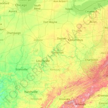
Name: Topografische Karte Ohio River, Höhe, Relief.
Ort: Ohio River, United States (36.98350 -89.17727 40.69668 -80.01712)
Durchschnittliche Höhe: 293 m
Minimale Höhe: 79 m
Maximale Höhe: 1.945 m
The river became a primary transportation route for pioneers during the westward expansion of the early U.S. The lower Ohio River just below Louisville was obstructed by rapids known as the Falls of the Ohio where the elevation falls 26 feet (7.9 m) in 2 miles (3.2 km) restricting larger commercial navigation, although in the 18th and early 19th century its three deepest channels could be traversed by a wide variety of craft then in use. In 1830, the Louisville and Portland Canal (now the McAlpine Locks and Dam) bypassed the rapids, allowing even larger commercial and modern navigation from the Forks of the Ohio at Pittsburgh to the Port of New Orleans at the mouth of the Mississippi on the Gulf of Mexico. Since the "canalization" of the river in 1929, the Ohio has not been a natural free-flowing river; today, it is divided into 21 discrete pools or reservoirs by 20 locks and dams for navigation and power generation.
Andere topografische Karten
Klicken Sie auf eine Karte, um ihre Topografie, ihre Höhe und ihr Relief anzuzeigen.
Brooklyn
United States > New York > New York
Brooklyn, Kings County, New York, United States
Durchschnittliche Höhe: 9 m
Los Angeles
Los Angeles, California, United States
Durchschnittliche Höhe: 241 m
Houston
United States > Texas > Harris County
Houston, Harris County, Texas, United States
Durchschnittliche Höhe: 25 m
Santa Cruz
United States > California > Santa Cruz County
Santa Cruz, Santa Cruz County, California, United States
Durchschnittliche Höhe: 89 m
Albuquerque
United States > New Mexico > Bernalillo County
Albuquerque, Bernalillo County, New Mexico, United States
Durchschnittliche Höhe: 1.688 m
New Orleans
United States > Louisiana > Orleans Parish
New Orleans, Orleans Parish, Louisiana, United States
Durchschnittliche Höhe: 1 m
Boulder
United States > Colorado > Boulder County
Boulder, Boulder County, Colorado, United States
Durchschnittliche Höhe: 1.785 m
Appalachian Mountains
United States > North Carolina > Yancey County
Appalachian Mountains, Yancey County, North Carolina, United States
Durchschnittliche Höhe: 1.463 m
Des Moines
United States > Iowa > Polk County
Des Moines, Polk County, Iowa, United States
Durchschnittliche Höhe: 264 m
Mount Hood
United States > Oregon > Hood River County
Mount Hood, Hood River County, Oregon, United States
Durchschnittliche Höhe: 2.716 m
Arlington
United States > Massachusetts > Middlesex County
Arlington, Middlesex County, Massachusetts, United States
Durchschnittliche Höhe: 35 m
Worcester
United States > Massachusetts > Worcester County
Worcester, Worcester County, Massachusetts, United States
Durchschnittliche Höhe: 186 m
Baldwin County
Baldwin County, Alabama, United States
Durchschnittliche Höhe: 31 m
Amelia Island
United States > Florida > Nassau County > Fernandina Beach
Amelia Island, Fernandina Beach, Nassau County, Florida, 32034, United States
Durchschnittliche Höhe: 3 m
Salt Lake County
Salt Lake County, Utah, United States
Durchschnittliche Höhe: 1.811 m
Fairfax County
Fairfax County, Virginia, United States
Durchschnittliche Höhe: 75 m
Lancaster County
Lancaster County, Pennsylvania, United States
Durchschnittliche Höhe: 158 m
Manhattan
United States > New York > New York County > New York
Manhattan, New York County, New York, United States
Durchschnittliche Höhe: 16 m
Brunswick County
United States > North Carolina
Brunswick County, North Carolina, United States
Durchschnittliche Höhe: 9 m
Bronx County
United States > New York > New York
Bronx County, The Bronx, New York, United States
Durchschnittliche Höhe: 21 m
Lexington
United States > Kentucky > Lexington
Lexington, Fayette County, Kentucky, 40508, United States
Durchschnittliche Höhe: 285 m