
Topografische Karte Washington
Interaktive Karte
Klicken Sie auf die Karte, um die Höhe anzuzeigen.
Über diese Karte
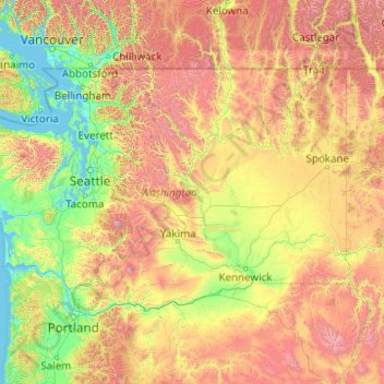
Name: Topografische Karte Washington, Höhe, Relief.
Ort: Washington, United States (45.54372 -124.83609 49.00244 -116.91599)
Durchschnittliche Höhe: 796 m
Minimale Höhe: -2 m
Maximale Höhe: 4.170 m
Washington is the 18th-largest state, with an area of 71,362 square miles (184,830 km2), and the 13th-most populous state, with more than 7.7 million people. The majority of Washington's residents live in the Seattle metropolitan area, the center of transportation, business, and industry on Puget Sound, an inlet of the Pacific Ocean consisting of numerous islands, deep fjords, and bays carved out by glaciers. The remainder of the state consists of deep temperate rainforests in the west; mountain ranges in the west, central, northeast, and far southeast; and a semi-arid basin region in the east, central, and south, given over to intensive agriculture. Washington is the second most populous state on the West Coast and in the Western United States, after California. Mount Rainier, an active stratovolcano, is the state's highest elevation at 14,411 feet (4,392 meters), and is the most topographically prominent mountain in the contiguous U.S.
Andere topografische Karten
Klicken Sie auf eine Karte, um ihre Topografie, ihre Höhe und ihr Relief anzuzeigen.
Los Angeles
Los Angeles, California, United States
Durchschnittliche Höhe: 241 m
Houston
United States > Texas > Harris County
Houston, Harris County, Texas, United States
Durchschnittliche Höhe: 25 m
Spokane
United States > Washington > Spokane County
Spokane, Spokane County, Washington, United States
Durchschnittliche Höhe: 655 m
New Orleans
United States > Louisiana > Orleans Parish
New Orleans, Orleans Parish, Louisiana, United States
Durchschnittliche Höhe: 1 m
Central Park
United States > New York > New York County > New York
Central Park, New York County, New York, United States
Durchschnittliche Höhe: 26 m
Jacksonville
United States > Florida > Duval County
Jacksonville, Duval County, Florida, United States
Durchschnittliche Höhe: 10 m
Albuquerque
United States > New Mexico > Bernalillo County
Albuquerque, Bernalillo County, New Mexico, United States
Durchschnittliche Höhe: 1.688 m
Des Moines
United States > Iowa > Polk County
Des Moines, Polk County, Iowa, United States
Durchschnittliche Höhe: 264 m
Aurora
United States > Colorado > Adams County
Aurora, Adams County, Colorado, United States
Durchschnittliche Höhe: 1.691 m
Brooklyn
United States > New York > New York
Brooklyn, Kings County, New York, United States
Durchschnittliche Höhe: 9 m
Hillsborough County
Hillsborough County, Florida, United States
Durchschnittliche Höhe: 20 m
Madison
United States > Wisconsin > Dane County
Madison, Dane County, Wisconsin, United States
Durchschnittliche Höhe: 284 m
Kauai
United States > Hawaii > Kauaʻi County
Kauai, Kauaʻi County, Hawaii, United States
Durchschnittliche Höhe: 216 m
Taos
United States > New Mexico > Taos County
Taos, Taos County, New Mexico, United States
Durchschnittliche Höhe: 2.180 m
Parker
United States > Colorado > Douglas County
Parker, Douglas County, Colorado, 80134, United States
Durchschnittliche Höhe: 1.845 m
San Mateo County
San Mateo County, California, United States
Durchschnittliche Höhe: 109 m
Littleton
United States > Colorado > Arapahoe County
Littleton, Arapahoe County, Colorado, United States
Durchschnittliche Höhe: 1.684 m
Miami-Dade County
Miami-Dade County, Florida, United States
Durchschnittliche Höhe: 3 m
Boulder
United States > Colorado > Boulder County
Boulder, Boulder County, Colorado, United States
Durchschnittliche Höhe: 1.785 m
Staten Island
United States > New York > New York
Staten Island, Richmond County, New York, United States
Durchschnittliche Höhe: 9 m
Joshua Tree National Park
Joshua Tree National Park, California, United States
Durchschnittliche Höhe: 639 m
Lancaster County
Lancaster County, Pennsylvania, United States
Durchschnittliche Höhe: 158 m