
Topografische Karte Iowa
Interaktive Karte
Klicken Sie auf die Karte, um die Höhe anzuzeigen.
Über diese Karte
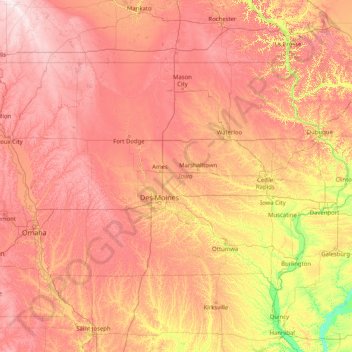
Name: Topografische Karte Iowa, Höhe, Relief.
Ort: Iowa, United States (40.37560 -96.63972 43.50116 -90.14006)
Durchschnittliche Höhe: 316 m
Minimale Höhe: 129 m
Maximale Höhe: 602 m
Iowa can be divided into eight landforms based on glaciation, soils, topography, and river drainage. Loess hills lie along the western border of the state, some of which are several hundred feet thick. Northeast Iowa along the Upper Mississippi River is part of the Driftless Area, consisting of steep hills and valleys which appear as mountainous.
Andere topografische Karten
Klicken Sie auf eine Karte, um ihre Topografie, ihre Höhe und ihr Relief anzuzeigen.
Houston
United States > Texas > Harris County
Houston, Harris County, Texas, United States
Durchschnittliche Höhe: 25 m
Los Angeles
Los Angeles, California, United States
Durchschnittliche Höhe: 241 m
Montgomery County
Montgomery County, Texas, United States
Durchschnittliche Höhe: 69 m
The Woodlands
United States > Texas > Montgomery County
The Woodlands, Montgomery County, Texas, United States
Durchschnittliche Höhe: 47 m
Albuquerque
United States > New Mexico > Bernalillo County
Albuquerque, Bernalillo County, New Mexico, United States
Durchschnittliche Höhe: 1.688 m
New Orleans
United States > Louisiana > Orleans Parish
New Orleans, Orleans Parish, Louisiana, United States
Durchschnittliche Höhe: 1 m
Fort Worth
United States > Texas > Tarrant County
Fort Worth, Tarrant County, Texas, United States
Durchschnittliche Höhe: 212 m
Bay Mills
United States > Michigan > Chippewa County
Bay Mills, Bay Mills Township, Chippewa County, Michigan, 49715, United States
Durchschnittliche Höhe: 182 m
Brooklyn
United States > New York > New York
Brooklyn, Kings County, New York, United States
Durchschnittliche Höhe: 9 m
Seattle
United States > Washington > King County
Seattle, King County, Washington, United States
Durchschnittliche Höhe: 40 m
Georgetown
United States > Texas > Georgetown
Georgetown, Williamson County, Texas, United States
Durchschnittliche Höhe: 219 m
Jacksonville
United States > Florida > Duval County
Jacksonville, Duval County, Florida, United States
Durchschnittliche Höhe: 10 m
Sequoia National Park
United States > California > Tulare County
Sequoia National Park, Tulare County, California, United States
Durchschnittliche Höhe: 2.515 m
Sacramento
United States > California > Sacramento County
Sacramento, Sacramento County, California, United States
Durchschnittliche Höhe: 10 m
Palm Beach County
Palm Beach County, Florida, United States
Durchschnittliche Höhe: 5 m
Central Valley
United States > California > San Joaquin County
Central Valley, San Joaquin County, California, 95201, United States
Durchschnittliche Höhe: -1 m
Staten Island
United States > New York > New York
Staten Island, Richmond County, New York, United States
Durchschnittliche Höhe: 9 m
Buncombe County
United States > North Carolina
Buncombe County, North Carolina, United States
Durchschnittliche Höhe: 839 m
Sarasota
United States > Florida > Sarasota County
Sarasota, Sarasota County, Florida, United States
Durchschnittliche Höhe: 7 m
Sonoma County
Sonoma County, California, United States
Durchschnittliche Höhe: 210 m