Geolokalisieren

Topografische Karte Galway Bay - Cuan na Gaillimhe

Interaktive Karte

Klicken Sie auf die Karte, um die Höhe anzuzeigen.

Über diese Karte

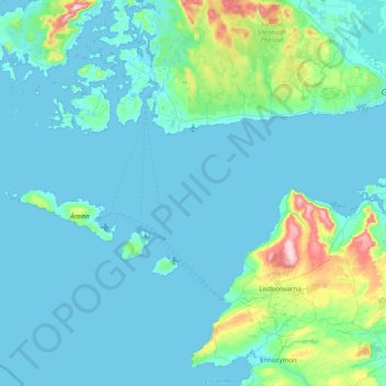
Name: Topografische Karte Galway Bay - Cuan na Gaillimhe, Höhe, Relief.

Ort: Galway Bay - Cuan na Gaillimhe, County Galway, Connacht, Irland (53.03502 -9.78882 53.26172 -8.98750)

Durchschnittliche Höhe: 35 m

Minimale Höhe: -2 m

Maximale Höhe: 346 m

Andere topografische Karten

Klicken Sie auf eine Karte, um ihre Topografie, ihre Höhe und ihr Relief anzuzeigen.

Galway

Irland > County Galway

Galway, County Galway, Connacht, Irland

Durchschnittliche Höhe: 16 m

Tuam Municipal District

Irland > County Galway

Tuam Municipal District, County Galway, Connacht, Irland

Durchschnittliche Höhe: 54 m

Loughrea Municipal District

Irland > County Galway

Loughrea Municipal District, County Galway, Connacht, Irland

Durchschnittliche Höhe: 69 m

Knocknagoneen

Irland > County Galway > Cathair na Gaillimhe > Galway Municipal District

Knocknagoneen, Knocknacarragh, Galway Municipal District, Cathair na Gaillimhe, County Galway, Connacht, H91 R6PW, Irland

Durchschnittliche Höhe: 5 m