
Topografische Karte Galway
Interaktive Karte
Klicken Sie auf die Karte, um die Höhe anzuzeigen.
Über diese Karte
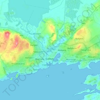
Name: Topografische Karte Galway, Höhe, Relief.
Ort: Galway, County Galway, Connacht, Irland (53.24852 -9.14269 53.31974 -8.95484)
Durchschnittliche Höhe: 16 m
Minimale Höhe: -3 m
Maximale Höhe: 103 m
Andere topografische Karten
Klicken Sie auf eine Karte, um ihre Topografie, ihre Höhe und ihr Relief anzuzeigen.
Tuam Municipal District
Tuam Municipal District, County Galway, Connacht, Irland
Durchschnittliche Höhe: 54 m
Loughrea Municipal District
Loughrea Municipal District, County Galway, Connacht, Irland
Durchschnittliche Höhe: 69 m
Galway Bay - Cuan na Gaillimhe
Galway Bay - Cuan na Gaillimhe, County Galway, Connacht, Irland
Durchschnittliche Höhe: 35 m
Knocknagoneen
Irland > County Galway > Cathair na Gaillimhe > Galway Municipal District
Knocknagoneen, Knocknacarragh, Galway Municipal District, Cathair na Gaillimhe, County Galway, Connacht, H91 R6PW, Irland
Durchschnittliche Höhe: 5 m