
Topografische Karte Tuam Municipal District
Interaktive Karte
Klicken Sie auf die Karte, um die Höhe anzuzeigen.
Über diese Karte
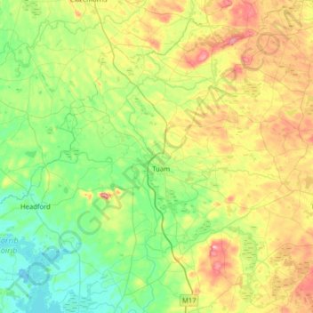
Name: Topografische Karte Tuam Municipal District, Höhe, Relief.
Ort: Tuam Municipal District, County Galway, Connacht, Irland (53.38694 -9.26636 53.67129 -8.62969)
Durchschnittliche Höhe: 54 m
Minimale Höhe: 4 m
Maximale Höhe: 165 m
Andere topografische Karten
Klicken Sie auf eine Karte, um ihre Topografie, ihre Höhe und ihr Relief anzuzeigen.
Loughrea Municipal District
Loughrea Municipal District, County Galway, Connacht, Irland
Durchschnittliche Höhe: 69 m
Galway Bay - Cuan na Gaillimhe
Galway Bay - Cuan na Gaillimhe, County Galway, Connacht, Irland
Durchschnittliche Höhe: 35 m
Knocknagoneen
Irland > County Galway > Cathair na Gaillimhe > Galway Municipal District
Knocknagoneen, Knocknacarragh, Galway Municipal District, Cathair na Gaillimhe, County Galway, Connacht, H91 R6PW, Irland
Durchschnittliche Höhe: 5 m