
Topografische Karte La Glace
Interaktive Karte
Klicken Sie auf die Karte, um die Höhe anzuzeigen.
Über diese Karte
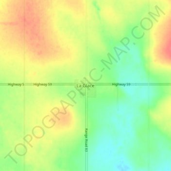
Name: Topografische Karte La Glace, Höhe, Relief.
Ort: La Glace, Division No. 19, Alberta, T0H 2J0, Canada (55.38296 -119.17437 55.42296 -119.13437)
Durchschnittliche Höhe: 738 m
Minimale Höhe: 713 m
Maximale Höhe: 764 m
La Glace is a hamlet in northern Alberta, Canada within the County of Grande Prairie No. 1. It is located along Highway 59 between Sexsmith and Valhalla Centre and has an elevation of 735 metres (2,411 ft).
Andere topografische Karten
Klicken Sie auf eine Karte, um ihre Topografie, ihre Höhe und ihr Relief anzuzeigen.
Clairmont
Canada > Alberta > Division No. 19 > Hamlet of Clairmont
Clairmont, Hamlet of Clairmont, Division No. 19, Alberta, T0H 0W0, Canada
Durchschnittliche Höhe: 679 m
Village of Donnelly
Canada > Alberta > Division No. 19
Village of Donnelly, Division No. 19, Alberta, Canada
Durchschnittliche Höhe: 594 m
Grande Prairie
Canada > Alberta > Division No. 19
Grande Prairie, Division No. 19, Alberta, Canada
Durchschnittliche Höhe: 665 m
Beaverlodge
Canada > Alberta > Division No. 19
Beaverlodge, Division No. 19, Alberta, T0H 0C0, Canada
Durchschnittliche Höhe: 735 m