
Topografische Karte Portsmouth
Interaktive Karte
Klicken Sie auf die Karte, um die Höhe anzuzeigen.
Über diese Karte
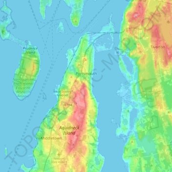
Name: Topografische Karte Portsmouth, Höhe, Relief.
Ort: Portsmouth, Newport County, Rhode Island, United States (41.51563 -71.37305 41.66686 -71.21392)
Durchschnittliche Höhe: 19 m
Minimale Höhe: -4 m
Maximale Höhe: 93 m
Andere topografische Karten
Klicken Sie auf eine Karte, um ihre Topografie, ihre Höhe und ihr Relief anzuzeigen.
Fort Wetherill
United States > Rhode Island > Newport County > Jamestown
Fort Wetherill, Highland Drive, Jamestown, Newport County, Rhode Island, 02835, United States
Durchschnittliche Höhe: 4 m
Aquidneck Island
United States > Rhode Island > Newport County > Portsmouth
Aquidneck Island, Portsmouth, Newport County, Rhode Island, United States
Durchschnittliche Höhe: 13 m
Newport
United States > Rhode Island > Newport County
Newport, Newport County, Rhode Island, 02840, United States
Durchschnittliche Höhe: 8 m
Pocasset Hill
United States > Rhode Island > Newport County > Tiverton
Pocasset Hill, Tiverton, Newport County, Rhode Island, 02878, United States
Durchschnittliche Höhe: 51 m
Jamestown
United States > Rhode Island > Newport County
Jamestown, Newport County, Rhode Island, 02835, United States
Durchschnittliche Höhe: 8 m
Middletown
United States > Rhode Island > Newport County
Middletown, Newport County, Rhode Island, 02842, United States
Durchschnittliche Höhe: 19 m
Tiverton
United States > Rhode Island > Newport County
Tiverton, Newport County, Rhode Island, 02878, United States
Durchschnittliche Höhe: 31 m