
Topografische Karte Tiverton
Interaktive Karte
Klicken Sie auf die Karte, um die Höhe anzuzeigen.
Über diese Karte
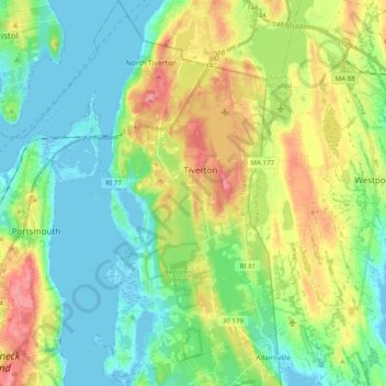
Name: Topografische Karte Tiverton, Höhe, Relief.
Ort: Tiverton, Newport County, Rhode Island, 02878, United States (41.54544 -71.22130 41.67509 -71.12784)
Durchschnittliche Höhe: 31 m
Minimale Höhe: -5 m
Maximale Höhe: 93 m
Much of the town is located along a granite ridge which runs in a north–south direction, rising approximately 170 feet in elevation from the bay. A large section of exposed granite can be observed at the highway cut for Route 24, near the Main Road interchange.
Andere topografische Karten
Klicken Sie auf eine Karte, um ihre Topografie, ihre Höhe und ihr Relief anzuzeigen.
Portsmouth
United States > Rhode Island > Newport County
Portsmouth, Newport County, Rhode Island, United States
Durchschnittliche Höhe: 19 m
Fort Wetherill
United States > Rhode Island > Newport County > Jamestown
Fort Wetherill, Highland Drive, Jamestown, Newport County, Rhode Island, 02835, United States
Durchschnittliche Höhe: 4 m
Aquidneck Island
United States > Rhode Island > Newport County > Portsmouth
Aquidneck Island, Portsmouth, Newport County, Rhode Island, United States
Durchschnittliche Höhe: 13 m
Newport
United States > Rhode Island > Newport County
Newport, Newport County, Rhode Island, 02840, United States
Durchschnittliche Höhe: 8 m
Pocasset Hill
United States > Rhode Island > Newport County > Tiverton
Pocasset Hill, Tiverton, Newport County, Rhode Island, 02878, United States
Durchschnittliche Höhe: 51 m
Jamestown
United States > Rhode Island > Newport County
Jamestown, Newport County, Rhode Island, 02835, United States
Durchschnittliche Höhe: 8 m
Middletown
United States > Rhode Island > Newport County
Middletown, Newport County, Rhode Island, 02842, United States
Durchschnittliche Höhe: 19 m
Little Compton
United States > Rhode Island > Newport County
Little Compton, Newport County, Rhode Island, United States
Durchschnittliche Höhe: 9 m