
Topografische Karte Niihau
Interaktive Karte
Klicken Sie auf die Karte, um die Höhe anzuzeigen.
Über diese Karte
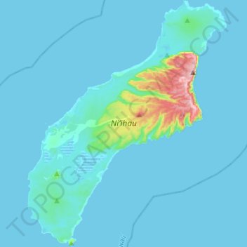
Name: Topografische Karte Niihau, Höhe, Relief.
Ort: Niihau, Kauaʻi County, Hawaii, United States of America (21.77906 -160.24700 22.00540 -160.04962)
Durchschnittliche Höhe: 23 m
Minimale Höhe: -2 m
Maximale Höhe: 386 m
Niʻihau is located about 18 miles (29 km) west of Kauaʻi, and the tiny, uninhabited island of Lehua lies 0.7 miles (0.61 nmi; 1.1 km) north of Niʻihau. Niʻihau's dimensions are 6.2 miles by 18.6 miles (10 km × 30 km). The maximum elevation (Paniau) is 1,280 feet (390 m). The island is about 6 million years old, making it geologically older than the 5.8-million-year-old neighboring island of Kauaʻi to the northeast. Niʻihau is the remnant of the southwestern slope of what was once a much larger volcano. The entire summit and other slopes collapsed into the ocean in a giant prehistoric landslide.
Andere topografische Karten
Klicken Sie auf eine Karte, um ihre Topografie, ihre Höhe und ihr Relief anzuzeigen.
Hilo
United States of America > Hawaii > Hilo
Hilo, Hawaiʻi County, Hawaii, 96720, United States of America
Durchschnittliche Höhe: 313 m
Kurtistown
United States of America > Hawaii > Keaʻau > Kurtistown
Kurtistown, Keaʻau, Hawaiʻi County, Hawaii, 96760, United States of America
Durchschnittliche Höhe: 181 m
Aiea
United States of America > Hawaii > Aiea
Aiea, Honolulu County, Hawaii, 96701, United States of America
Durchschnittliche Höhe: 147 m
Haiku
United States of America > Hawaii > Haiku
Haiku, Maui County, Hawaii, United States of America
Durchschnittliche Höhe: 160 m
Hualālai
United States of America > Hawaii > Kailua-Kona
Hualālai, Kailua-Kona, Hawaiʻi County, Hawaii, United States of America
Durchschnittliche Höhe: 2.291 m
Nīnole
United States of America > Hawaii > Nīnole
Nīnole, Hawaiʻi County, Hawaii, 96773, United States of America
Durchschnittliche Höhe: 141 m
Lisianski Island
United States of America > Hawaii
Lisianski Island, Honolulu County, Hawaii, United States of America
Durchschnittliche Höhe: 1 m
Pulehu
United States of America > Hawaii > Kula > Pulehu
Pulehu, Kula, Maui, Hawaii, 96790, United States of America
Durchschnittliche Höhe: 760 m
Whitmore Village
United States of America > Hawaii > Whitmore Village
Whitmore Village, Honolulu County, Hawaii, 96786, United States of America
Durchschnittliche Höhe: 306 m
Hawaiʻi Volcanoes National Park/Kahuku Ranch Cooperative Nene Sanctuary
United States of America > Hawaii > Kailua-Kona
Hawaiʻi Volcanoes National Park/Kahuku Ranch Cooperative Nene Sanctuary, Old Hawaiian Trl, Kailua-Kona, Hawaiʻi County, Hawaii, United States of America
Durchschnittliche Höhe: 1.910 m
Waahila
United States of America > Hawaii > Honolulu
Waahila, Honolulu, Honolulu County, Hawaii, 96848, United States of America
Durchschnittliche Höhe: 83 m
Pauoa Stream
United States of America > Hawaii > Honolulu
Pauoa Stream, Honolulu, Honolulu County, Hawaii, 96817, United States of America
Durchschnittliche Höhe: 31 m
Laysan
United States of America > Hawaii
Laysan, Honolulu County, Hawaii, United States of America
Durchschnittliche Höhe: 1 m
Hawi
United States of America > Hawaii > Hawi
Hawi, Hawaiʻi County, Hawaii, 96719, United States of America
Durchschnittliche Höhe: 170 m
Pauwela
United States of America > Hawaii > Haiku > Pauwela
Pauwela, Haiku, Maui County, Hawaii, United States of America
Durchschnittliche Höhe: 68 m
Haliimaile
United States of America > Hawaii > Haliimaile > Haliimaile
Haliimaile, Maui County, Hawaii, 96768, United States of America
Durchschnittliche Höhe: 319 m
Makawao
United States of America > Hawaii > Makawao > Makawao
Makawao, Maui County, Hawaii, 96768, United States of America
Durchschnittliche Höhe: 509 m