
Topografische Karte Lisianski Island
Interaktive Karte
Klicken Sie auf die Karte, um die Höhe anzuzeigen.
Über diese Karte
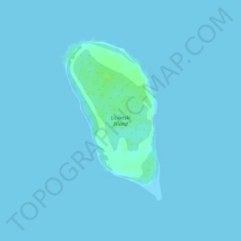
Name: Topografische Karte Lisianski Island, Höhe, Relief.
Durchschnittliche Höhe: 1 m
Minimale Höhe: 0 m
Maximale Höhe: 11 m
Lisianski Island (Hawaiian: Papa‘āpoho) is one of the Northwestern Hawaiian Islands, with a land area of 384.425 acres (155.571 ha) and a maximum elevation of 40 feet (12 m) above sea level. It is a low, flat sand and coral island about 905 nautical miles (1,676 km) northwest of Honolulu. The island is surrounded by reefs and shoals, including the extensive Neva Shoals. Access to the island is limited by helicopter or by boat to a narrow sandy inlet on the southeastern side of the island.
Andere topografische Karten
Klicken Sie auf eine Karte, um ihre Topografie, ihre Höhe und ihr Relief anzuzeigen.
Niihau
United States of America > Hawaii
Niihau, Kauaʻi County, Hawaii, United States of America
Durchschnittliche Höhe: 23 m
Hilo
United States of America > Hawaii > Hilo
Hilo, Hawaiʻi County, Hawaii, 96720, United States of America
Durchschnittliche Höhe: 313 m
Kurtistown
United States of America > Hawaii > Keaʻau > Kurtistown
Kurtistown, Keaʻau, Hawaiʻi County, Hawaii, 96760, United States of America
Durchschnittliche Höhe: 181 m
Aiea
United States of America > Hawaii > Aiea
Aiea, Honolulu County, Hawaii, 96701, United States of America
Durchschnittliche Höhe: 147 m
Haiku
United States of America > Hawaii > Haiku
Haiku, Maui County, Hawaii, United States of America
Durchschnittliche Höhe: 160 m
Hualālai
United States of America > Hawaii > Kailua-Kona
Hualālai, Kailua-Kona, Hawaiʻi County, Hawaii, United States of America
Durchschnittliche Höhe: 2.291 m
Nīnole
United States of America > Hawaii > Nīnole
Nīnole, Hawaiʻi County, Hawaii, 96773, United States of America
Durchschnittliche Höhe: 141 m
Pulehu
United States of America > Hawaii > Kula > Pulehu
Pulehu, Kula, Maui, Hawaii, 96790, United States of America
Durchschnittliche Höhe: 760 m
Whitmore Village
United States of America > Hawaii > Whitmore Village
Whitmore Village, Honolulu County, Hawaii, 96786, United States of America
Durchschnittliche Höhe: 306 m
Hawaiʻi Volcanoes National Park/Kahuku Ranch Cooperative Nene Sanctuary
United States of America > Hawaii > Kailua-Kona
Hawaiʻi Volcanoes National Park/Kahuku Ranch Cooperative Nene Sanctuary, Old Hawaiian Trl, Kailua-Kona, Hawaiʻi County, Hawaii, United States of America
Durchschnittliche Höhe: 1.910 m
Waahila
United States of America > Hawaii > Honolulu
Waahila, Honolulu, Honolulu County, Hawaii, 96848, United States of America
Durchschnittliche Höhe: 83 m
Pauoa Stream
United States of America > Hawaii > Honolulu
Pauoa Stream, Honolulu, Honolulu County, Hawaii, 96817, United States of America
Durchschnittliche Höhe: 31 m
Laysan
United States of America > Hawaii
Laysan, Honolulu County, Hawaii, United States of America
Durchschnittliche Höhe: 1 m
Hawi
United States of America > Hawaii > Hawi
Hawi, Hawaiʻi County, Hawaii, 96719, United States of America
Durchschnittliche Höhe: 170 m
Pauwela
United States of America > Hawaii > Haiku > Pauwela
Pauwela, Haiku, Maui County, Hawaii, United States of America
Durchschnittliche Höhe: 68 m
Haliimaile
United States of America > Hawaii > Haliimaile > Haliimaile
Haliimaile, Maui County, Hawaii, 96768, United States of America
Durchschnittliche Höhe: 319 m
Makawao
United States of America > Hawaii > Makawao > Makawao
Makawao, Maui County, Hawaii, 96768, United States of America
Durchschnittliche Höhe: 509 m