
Topografische Karte Rastislavice
Interaktive Karte
Klicken Sie auf die Karte, um die Höhe anzuzeigen.
Über diese Karte
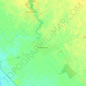
Name: Topografische Karte Rastislavice, Höhe, Relief.
Durchschnittliche Höhe: 125 m
Minimale Höhe: 114 m
Maximale Höhe: 134 m
The village lies at an altitude of 124 metres and covers an area of 19.589 km². It has a population of about 920 people.
Andere topografische Karten
Klicken Sie auf eine Karte, um ihre Topografie, ihre Höhe und ihr Relief anzuzeigen.
Strekov
Slovakia > Region of Nitra > District of Nové Zámky
Strekov, District of Nové Zámky, Region of Nitra, Western Slovakia, 941 37, Slovakia
Durchschnittliche Höhe: 163 m
Nové Zámky
Slovakia > Region of Nitra > District of Nové Zámky
Nové Zámky, District of Nové Zámky, Region of Nitra, Western Slovakia, Slovakia
Durchschnittliche Höhe: 116 m
Štúrovo
Slovakia > Region of Nitra > District of Nové Zámky
Štúrovo, District of Nové Zámky, Region of Nitra, Western Slovakia, Slovakia
Durchschnittliche Höhe: 115 m