
Topografische Karte Strekov
Interaktive Karte
Klicken Sie auf die Karte, um die Höhe anzuzeigen.
Über diese Karte
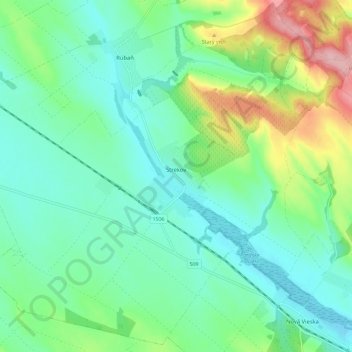
Name: Topografische Karte Strekov, Höhe, Relief.
Durchschnittliche Höhe: 163 m
Minimale Höhe: 121 m
Maximale Höhe: 277 m
The municipality lies at an altitude of 132 metres and covers an area of 41.055 km.
Andere topografische Karten
Klicken Sie auf eine Karte, um ihre Topografie, ihre Höhe und ihr Relief anzuzeigen.
Rastislavice
Slovakia > Region of Nitra > District of Nové Zámky
Rastislavice, District of Nové Zámky, Region of Nitra, Western Slovakia, 941 08, Slovakia
Durchschnittliche Höhe: 125 m
Nové Zámky
Slovakia > Region of Nitra > District of Nové Zámky
Nové Zámky, District of Nové Zámky, Region of Nitra, Western Slovakia, Slovakia
Durchschnittliche Höhe: 116 m
Štúrovo
Slovakia > Region of Nitra > District of Nové Zámky
Štúrovo, District of Nové Zámky, Region of Nitra, Western Slovakia, Slovakia
Durchschnittliche Höhe: 115 m