
Topografische Karte The Municipal District of Kanturk – Mallow
Interaktive Karte
Klicken Sie auf die Karte, um die Höhe anzuzeigen.
Über diese Karte
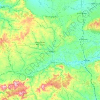
Name: Topografische Karte The Municipal District of Kanturk – Mallow, Höhe, Relief.
Durchschnittliche Höhe: 182 m
Minimale Höhe: 39 m
Maximale Höhe: 679 m
Andere topografische Karten
Klicken Sie auf eine Karte, um ihre Topografie, ihre Höhe und ihr Relief anzuzeigen.
Tullagreen
Irland > County Cork > Municipal District of Cobh
Tullagreen, Carrigtohill ED, Municipal District of Cobh, County Cork, Munster, Irland
Durchschnittliche Höhe: 12 m