
Spenden
Rüsten Sie sich für Ihr nächstes Abenteuer:
Als Amazon-Partner erhält diese Website eine Provision für qualifizierte Käufe, ohne zusätzliche Kosten für Sie.
Topografische Karte Crook County
Klicken Sie auf die Karte, um die Höhe anzuzeigen.
Spenden
Rüsten Sie sich für Ihr nächstes Abenteuer:
Als Amazon-Partner erhält diese Website eine Provision für qualifizierte Käufe, ohne zusätzliche Kosten für Sie.
Über diese Karte
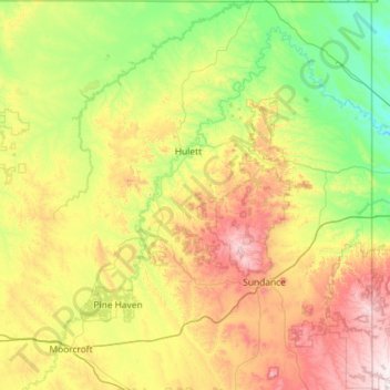
Name: Topografische Karte Crook County, Höhe, Relief.
Ort: Crook County, Wyoming, United States (44.17616 -105.08607 45.00018 -104.05456)
Durchschnittliche Höhe: 1.300 m
Minimale Höhe: 941 m
Maximale Höhe: 2.093 m
Spenden
Rüsten Sie sich für Ihr nächstes Abenteuer:
Als Amazon-Partner erhält diese Website eine Provision für qualifizierte Käufe, ohne zusätzliche Kosten für Sie.
Andere topografische Karten
Klicken Sie auf eine Karte, um ihre Topografie, ihre Höhe und ihr Relief anzuzeigen.
Rocky Mountains
United States > Wyoming > Teton County
Agriculture and forestry are major industries. Agriculture includes dryland and irrigated farming and livestock grazing. Livestock are frequently moved between high-elevation summer pastures and low-elevation winter pastures, a practice known as transhumance.
Durchschnittliche Höhe: 2.292 m
Medicine Bow Peak
United States > Wyoming > Albany County
Medicine Bow Peak (12,018 ft (3,663 m)) is the highest peak in the Snowy Range, a part of the Medicine Bow Mountains, about 35 miles (56 km) west of Laramie, Wyoming. It lies within Medicine Bow National Forest and is the highest point in southern Wyoming. The summit lies in extreme western Albany County, but…
Durchschnittliche Höhe: 3.396 m
Spenden
Rüsten Sie sich für Ihr nächstes Abenteuer:
Als Amazon-Partner erhält diese Website eine Provision für qualifizierte Käufe, ohne zusätzliche Kosten für Sie.
Togwotee Pass
United States > Wyoming > Teton County
Togwotee Pass (pronounced TOH-guh-tee) is a high mountain pass in the western United States, at an elevation of 9,655 feet (2,943 m) above sea level. On the Continental Divide in the Absaroka Range of northwestern Wyoming in Teton County, it is between Dubois and Moran Junction in the Jackson Hole valley.
Durchschnittliche Höhe: 2.965 m
Buck Mountain
United States > Wyoming > Teton County
Buck Mountain (elevation: 11,943 feet (3,640 m)) is a mountain located in the Teton Range, Grand Teton National Park, Wyoming, immediately southeast of Grand Teton.
Durchschnittliche Höhe: 3.128 m
Spenden
Rüsten Sie sich für Ihr nächstes Abenteuer:
Als Amazon-Partner erhält diese Website eine Provision für qualifizierte Käufe, ohne zusätzliche Kosten für Sie.
Rocky Mountains
United States > Wyoming > Teton County
Agriculture and forestry are major industries. Agriculture includes dryland and irrigated farming and livestock grazing. Livestock are frequently moved between high-elevation summer pastures and low-elevation winter pastures, a practice known as transhumance.
Durchschnittliche Höhe: 2.292 m
Gannett Peak
United States > Wyoming > Fremont County
Gannett Peak is the highest mountain peak in the U.S. state of Wyoming at 13,810 feet (4,210 m). It lies in the Wind River Range within the Bridger Wilderness of the Bridger-Teton National Forest. Straddling the Continental Divide along the boundary between Fremont and Sublette counties, it has the second…
Durchschnittliche Höhe: 3.700 m
Spenden
Rüsten Sie sich für Ihr nächstes Abenteuer:
Als Amazon-Partner erhält diese Website eine Provision für qualifizierte Käufe, ohne zusätzliche Kosten für Sie.
Old Faithful
United States > Wyoming > Teton County > Upper Geyser Basin
Durchschnittliche Höhe: 2.284 m
Spenden
Rüsten Sie sich für Ihr nächstes Abenteuer:
Als Amazon-Partner erhält diese Website eine Provision für qualifizierte Käufe, ohne zusätzliche Kosten für Sie.
Goshen County Fair Grounds
United States > Wyoming > Goshen County > Torrington
Durchschnittliche Höhe: 1.258 m
Spenden
Rüsten Sie sich für Ihr nächstes Abenteuer:
Als Amazon-Partner erhält diese Website eine Provision für qualifizierte Käufe, ohne zusätzliche Kosten für Sie.
Teton Range
United States > Wyoming > Teton County
One reason the Teton Range is famous is because of the dramatic elevation profile visible from the eastern side, which rises sharply from 4,000 to 7,000 feet (1,200–2,100 m) above the valley floor. Unlike most mountain ranges, the east side of the Teton Range lacks significant foothills or lower peaks which…
Durchschnittliche Höhe: 2.985 m
Cloud Peak
United States > Wyoming > Big Horn County
Located in the 189,000-acre (765 km2) Cloud Peak Wilderness within Bighorn National Forest, the peak rises to an elevation of 13,171 feet (4,015 m). It can be climbed most easily from the western side, accessed by either the Battle Park or West Tensleep trailheads, which both form 24-mile (39 km) round trips…
Durchschnittliche Höhe: 3.598 m
Spenden
Rüsten Sie sich für Ihr nächstes Abenteuer:
Als Amazon-Partner erhält diese Website eine Provision für qualifizierte Käufe, ohne zusätzliche Kosten für Sie.
Casper Mountain
United States > Wyoming > Natrona County
Casper Mountain, an anticline, is located at the north end of the Laramie Mountains overlooking Casper, Wyoming along the North Platte River. At a top elevation of 8,130 feet (2,478 m), the geological feature rises approximately 3,000 feet (914 m) above Casper.
Durchschnittliche Höhe: 2.315 m
Spenden
Rüsten Sie sich für Ihr nächstes Abenteuer:
Als Amazon-Partner erhält diese Website eine Provision für qualifizierte Käufe, ohne zusätzliche Kosten für Sie.
Mount Washburn
United States > Wyoming > Park County
Mount Washburn, elevation 10,219 feet (3,115 m), is a prominent mountain peak in the Washburn Range in Yellowstone National Park, Wyoming. The peak was named in 1870 to honor Henry D. Washburn, leader of the Washburn–Langford–Doane Expedition. The Washburn Range is one of two mountains ranges completely…
Durchschnittliche Höhe: 2.798 m
Rendezvous Mountain
United States > Wyoming > Teton County > Teton Village
Durchschnittliche Höhe: 2.829 m
Jenny Lake
United States > Wyoming > Teton County
Jenny Lake is a starting point for many day and overnight hiking trips. The 7.1-mile (11.4 km) Jenny Lake Trail loops around the lake and is considered to be relatively easy due to the small altitude gain of 700 feet (210 m). However, the altitude increases rapidly once Cascade Canyon is entered.
Durchschnittliche Höhe: 2.109 m
Spenden
Rüsten Sie sich für Ihr nächstes Abenteuer:
Als Amazon-Partner erhält diese Website eine Provision für qualifizierte Käufe, ohne zusätzliche Kosten für Sie.
Spenden
Rüsten Sie sich für Ihr nächstes Abenteuer:
Als Amazon-Partner erhält diese Website eine Provision für qualifizierte Käufe, ohne zusätzliche Kosten für Sie.
Spenden
Rüsten Sie sich für Ihr nächstes Abenteuer:
Als Amazon-Partner erhält diese Website eine Provision für qualifizierte Käufe, ohne zusätzliche Kosten für Sie.
Druid Peak
United States > Wyoming > Park County
Druid Peak (elevation 9,577 feet (2,919 m)) is a moderate domed peak on the southern flank of the Absaroka Range in Yellowstone National Park. The peak lies just north of the Lamar River and Soda Butte Creek confluence at the head of the Lamar Valley. Prior to 1885, this summit was named Soda Hill by members…
Durchschnittliche Höhe: 2.597 m
Spenden
Rüsten Sie sich für Ihr nächstes Abenteuer:
Als Amazon-Partner erhält diese Website eine Provision für qualifizierte Käufe, ohne zusätzliche Kosten für Sie.
Spenden
Rüsten Sie sich für Ihr nächstes Abenteuer:
Als Amazon-Partner erhält diese Website eine Provision für qualifizierte Käufe, ohne zusätzliche Kosten für Sie.
Spenden
Rüsten Sie sich für Ihr nächstes Abenteuer:
Als Amazon-Partner erhält diese Website eine Provision für qualifizierte Käufe, ohne zusätzliche Kosten für Sie.
Hayden Valley
United States > Wyoming > Park County
A grassy valley, branching between low ridges, running from the river toward the center of the basin. A small stream rose in this valley, breaking through the ridges to the west in a deep cañon, and falling into the channel of the Yellowstone, which here bears in a northeast course, flowing in view as far as…
Durchschnittliche Höhe: 2.373 m
Sinks Canyon State Park
United States > Wyoming > Fremont County > Lander
Durchschnittliche Höhe: 2.133 m
Spenden
Rüsten Sie sich für Ihr nächstes Abenteuer:
Als Amazon-Partner erhält diese Website eine Provision für qualifizierte Käufe, ohne zusätzliche Kosten für Sie.
Yellowstone Caldera Supervolcano
United States > Wyoming > Teton County
Durchschnittliche Höhe: 2.530 m
Gannett Peak
United States > Wyoming > Fremont County
Gannett Peak is the highest mountain peak in the U.S. state of Wyoming at 13,810 feet (4,210 m). It lies in the Wind River Range within the Bridger Wilderness of the Bridger-Teton National Forest. Straddling the Continental Divide along the boundary between Fremont and Sublette counties, it has the second…
Durchschnittliche Höhe: 3.700 m
Spenden
Rüsten Sie sich für Ihr nächstes Abenteuer:
Als Amazon-Partner erhält diese Website eine Provision für qualifizierte Käufe, ohne zusätzliche Kosten für Sie.
Old Faithful
United States > Wyoming > Teton County > Upper Geyser Basin
Durchschnittliche Höhe: 2.284 m
Buck Mountain
United States > Wyoming > Teton County
Buck Mountain (elevation: 11,943 feet (3,640 m)) is a mountain located in the Teton Range, Grand Teton National Park, Wyoming, immediately southeast of Grand Teton.
Durchschnittliche Höhe: 3.128 m
Spenden
Rüsten Sie sich für Ihr nächstes Abenteuer:
Als Amazon-Partner erhält diese Website eine Provision für qualifizierte Käufe, ohne zusätzliche Kosten für Sie.
Spenden
Rüsten Sie sich für Ihr nächstes Abenteuer:
Als Amazon-Partner erhält diese Website eine Provision für qualifizierte Käufe, ohne zusätzliche Kosten für Sie.
Spenden
Rüsten Sie sich für Ihr nächstes Abenteuer:
Als Amazon-Partner erhält diese Website eine Provision für qualifizierte Käufe, ohne zusätzliche Kosten für Sie.
Spenden
Rüsten Sie sich für Ihr nächstes Abenteuer:
Als Amazon-Partner erhält diese Website eine Provision für qualifizierte Käufe, ohne zusätzliche Kosten für Sie.
Spenden
Rüsten Sie sich für Ihr nächstes Abenteuer:
Als Amazon-Partner erhält diese Website eine Provision für qualifizierte Käufe, ohne zusätzliche Kosten für Sie.
Spenden
Rüsten Sie sich für Ihr nächstes Abenteuer:
Als Amazon-Partner erhält diese Website eine Provision für qualifizierte Käufe, ohne zusätzliche Kosten für Sie.
Sulphur Creek Reservoir
United States > Wyoming > Uinta County > Hilliard
Durchschnittliche Höhe: 2.206 m
Laramie
United States > Wyoming > Albany County
Laramie (/ˈlærəmi/) is a city in and the county seat of Albany County, Wyoming, United States, known for its high elevation at 7,200 feet (2,200 m), railroad history, and is the home of the University of Wyoming. The population was 31,407 at the 2020 census, making it the fourth-most populous city in…
Durchschnittliche Höhe: 2.218 m
Spenden
Rüsten Sie sich für Ihr nächstes Abenteuer:
Als Amazon-Partner erhält diese Website eine Provision für qualifizierte Käufe, ohne zusätzliche Kosten für Sie.
Laramie
United States > Wyoming > Albany County
Laramie (/ˈlærəmi/) is a city in and the county seat of Albany County, Wyoming, United States, known for its high elevation at 7,200 feet (2,200 m), for its railroad history, and as the home of the University of Wyoming. The population was 31,407 at the 2020 census, making it the fourth-most populous city…
Durchschnittliche Höhe: 2.218 m
Spenden
Rüsten Sie sich für Ihr nächstes Abenteuer:
Als Amazon-Partner erhält diese Website eine Provision für qualifizierte Käufe, ohne zusätzliche Kosten für Sie.
Spenden
Rüsten Sie sich für Ihr nächstes Abenteuer:
Als Amazon-Partner erhält diese Website eine Provision für qualifizierte Käufe, ohne zusätzliche Kosten für Sie.
Spenden
Rüsten Sie sich für Ihr nächstes Abenteuer:
Als Amazon-Partner erhält diese Website eine Provision für qualifizierte Käufe, ohne zusätzliche Kosten für Sie.